David Leverington
Associate Professor
Overview
Among the landform types common to Venus, Mars, Mercury, and the Moon are large channel systems formed by voluminous fluid flows from the subsurface. These channels are sometimes referred to as "outflow channels".
Outflow channels generally head abruptly at topographic lows or ridged plains and extend downslope for distances of tens to thousands of kilometers. Lunar systems are relatively small, with channel widths of less than 10 km and typical lengths of less than 100 km. Though details are presently lacking, new data for Mercury suggest the presence of ancient outflow systems with maximum channel widths of at least 25 km. The largest of the Venusian and Martian outflow systems have widths of tens of kilometers and lengths of thousands of kilometers, and in many cases are characterized by complexly anastamosing reaches and large streamlined landforms.
In the material presented below, the basic characteristics and hypothesized formation mechanisms of outflow systems are outlined for the Moon, Mercury, Venus, and Mars (Sections 1-4). The volcanic hypothesis for development of the Martian outflow channels is further outlined in Section 5.

Figure i: Selected examples of large channels with characteristics strongly suggestive of volcanic origins [modified and corrected from Leverington, 2014]. Channel heads are marked by "H", except where sources are obscured or are otherwise unknown.
1 Outflow Channels of the Moon
Images generated by the Lunar Orbiter and Apollo missions have been used to identify a large number of lunar lava channels located in both mare and highland regions [e.g., Greeley, 1971ab, 1976; Young et al., 1973; Zisk et al., 1977; Strain and El-Baz, 1977; Wilhelms, 1987]. The Apollo 15 mission involved direct investigation of one of these channels, Hadley Rille, as well as the surrounding basaltic mare units of Palus Putredinis [Swann et al., 1972; Howard et al., 1972; Spudis and Pieters, 1991].
The characteristics of lunar sinuous rilles can include inner channels [e.g., El-Baz et al., 1972], channel levees [e.g., El-Baz and Roosa, 1972; Hulme, 1974; Schaber, 1973; Schultz, 1976], channel terraces [e.g., Schultz, 1976; Leverington, 2004a; see also El-Baz et al., 1972], typical gradients of less than one degree [Strain and El-Baz, 1977], longitudinal profiles intermittently characterized by reverse gradients [e.g., Greeley, 1971ab; Strain and El-Baz, 1977], and exposure of channel floors as a result of partial or complete drainage of late-stage lava pulses [e.g., Swann et al., 1972]. Rilles incised up to hundreds of meters into upland barriers across swaths as great as several kilometers exist on the Moon, with examples of incision located, e.g., at Rimae Herigonius [Greeley and Spudis, 1978; see also Young et al., 1973; Schultz, 1976; Leverington, 2006] and Rimae Prinz [Carr, 1974; Schultz, 1976; Strain and El-Baz, 1977; Zisk et al., 1977; see also Masursky et al., 1978; Leverington, 2004a]. Some lunar channels contain streamlined landforms that appear to be erosional residuals [Leverington, 2004a].
Although once believed to be ancient river channels and valleys [e.g., Urey, 1967; Peale et al., 1968; Lingenfelter et al., 1968; see also Zimbelman, 2001], the volcanic character of the channels, and the absence of hydrous minerals in sampled lunar materials [e.g., Schmitt et al., 1970; Papike et al., 1991], together strongly suggest that sinuous lunar rilles did not form by water flow (or even in the presence of water). Sinuous lunar rilles share numerous characteristics with terrestrial lava tubes and channels, and are interpreted to have also formed by the flow of lava [e.g., Hackman, 1966; McCauley, 1967; Oberbeck et al., 1969, Greeley, 1971a, Cruikshank and Wood, 1972; El-Baz and Roosa, 1972; Young et al., 1973; Schaber, 1973; also see summaries in Leverington, 2004a, 2006, 2009].
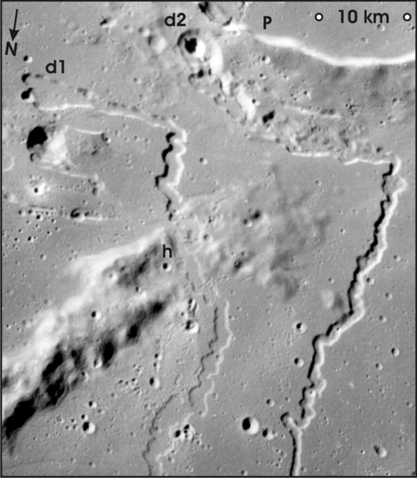
Figure 1: Oblique view of two channels of Rimae Prinz (figure center at ~27 degrees N, 44 degrees W), located north of lunar crater Prinz (P) [Leverington, 2004a]. As with many lunar outflow systems, these rilles commence abruptly at topographic depressions (d1 and d2); the rille associated with depression d1 crosses hills at h, suggesting structural control of channel position [Grolier, 1978], and/or incision processes that commenced prior to subsidence of mare materials [e.g., see Greeley and Spudis, 1978]. Scale is valid only in the upper-right corner of the image. Illumination is from the left. Apollo 15 Hasselblad frame AS15-93-12608.
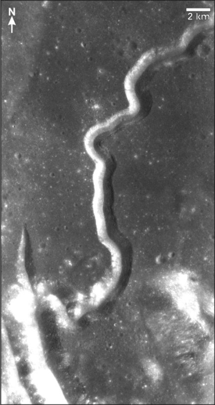
Figure 2: Hadley Rille (Rima Hadley), located in the lunar volcanic plains of Palus Putredinus, southeast Mare Imbrium [Apollo 15 Panoramic frame 9924; see also, e.g., Hackman, 1966] [Leverington, 2006]. This channel was visited by the astronauts of Apollo 15 (see below). Image center is at ~2.5 degrees E, 25 degrees N. Illumination is from the right.
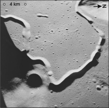
Figure 3: Oblique view of part of Rima Hadley (Hadley Rille), showing variable channel widths that may be related to the irregular collapse of a former channel roof along this segment [Apollo 15 Hasselblad frame AS15-87-11720; see also, e.g., Hackman, 1966; Leverington, 2006]. Scale is valid only in the top-left corner of the image. Image center is at ~3.5 degrees E, 26 degrees N. Illumination is from image bottom.
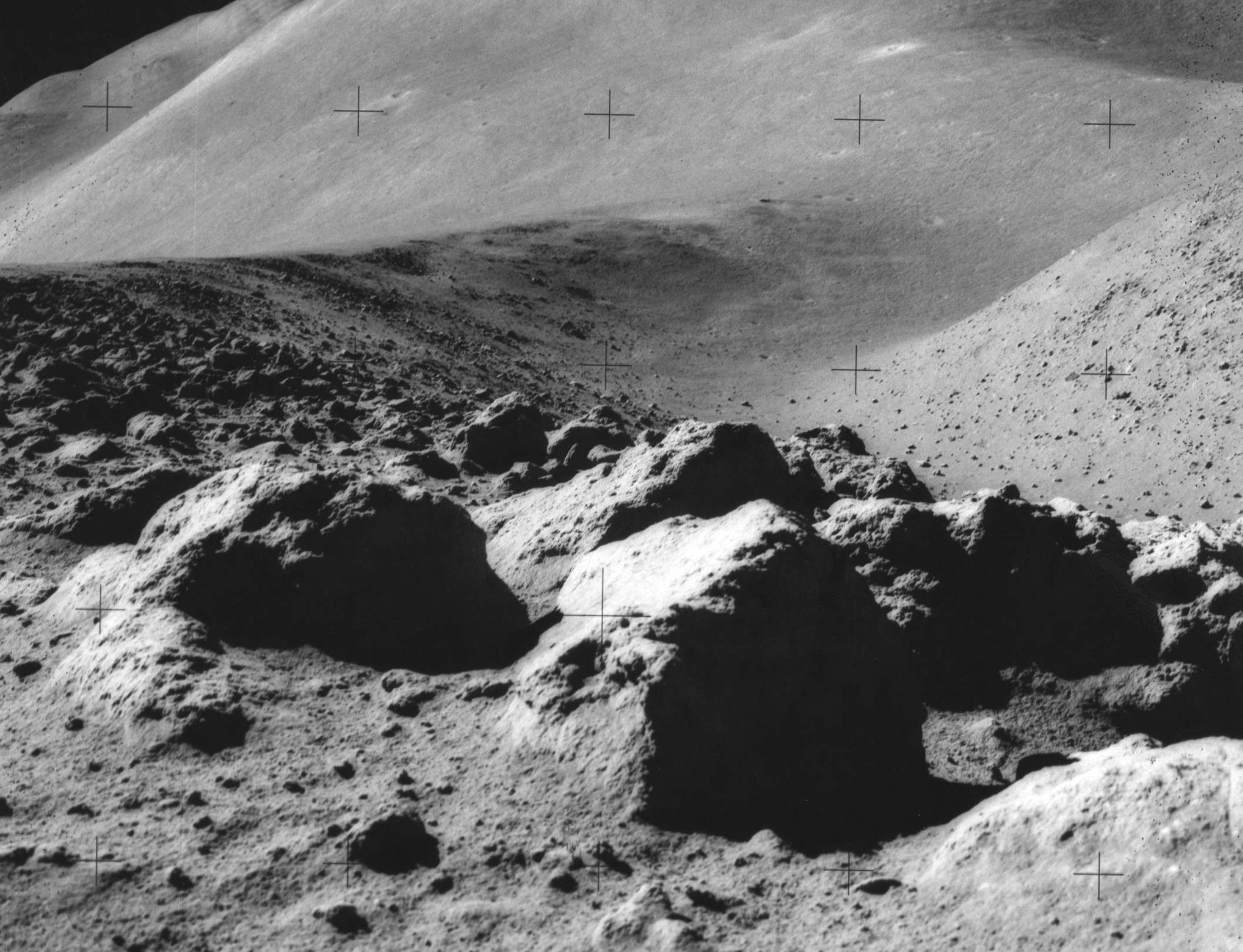
Figure 4: View of Hadley Rille from the ground. Apollo 15 astronauts David Scott and James Irwin used the first Lunar Rover to visit this and other sites in the Palus Putredinus region of eastern Mare Imbrium. About 77 kg of lunar samples were collected on this mission. The Apennine Front is visible in the distance, as is part of St. George crater (top-right corner). Apollo 15 Photo 82-11147.
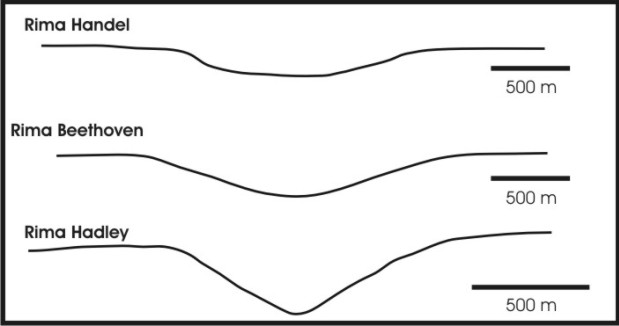
Figure 5: Cross-sectional profiles of three lunar rilles: Rima Handel [after Strain and El-Baz, 1977]; Rima Beethoven [after Strain and El-Baz, 1977]; and Rima Hadley (Hadley Rille) [after Wu et al., 1972] [Leverington, 2006]. Profiles contain no vertical exaggeration. The width-to-depth ratios of lunar rilles can vary considerably within and between individual systems, with ratios of ~4:1 to 11:1 roughly describing the most common ranges that have been measured in past lunar studies based on high-resolution photogrammetric analysis of Apollo Panoramic-Camera images.
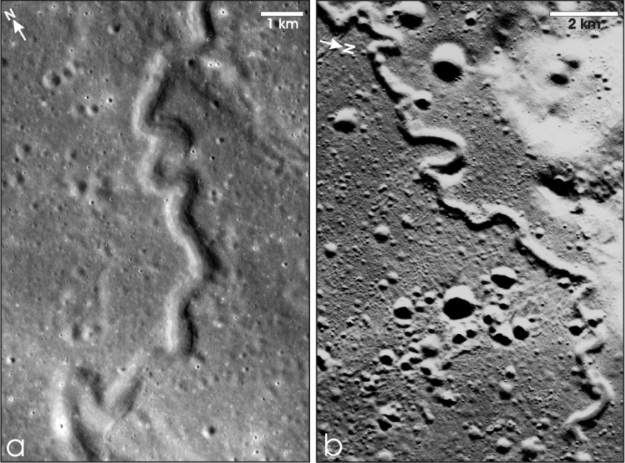
Figure 6: Highly sinuous lunar volcanic channels [Leverington, 2006]. a: Rima Diophantus, located north of crater Diophantus in southwestern Mare Imbrium. Image center is at ~35 degrees W, 28.75 degrees N (Apollo 15 Panchromatic frame 299); illumination is from the right. b: Sinuous rille located near the southern foot of Montes Agricola, north of Aristarchus Plateau in Oceanus Procellarum. Image center is at ~53.25 degrees W, 29.25 degrees N (Apollo 15 Panchromatic frame 349); illumination is from image bottom.
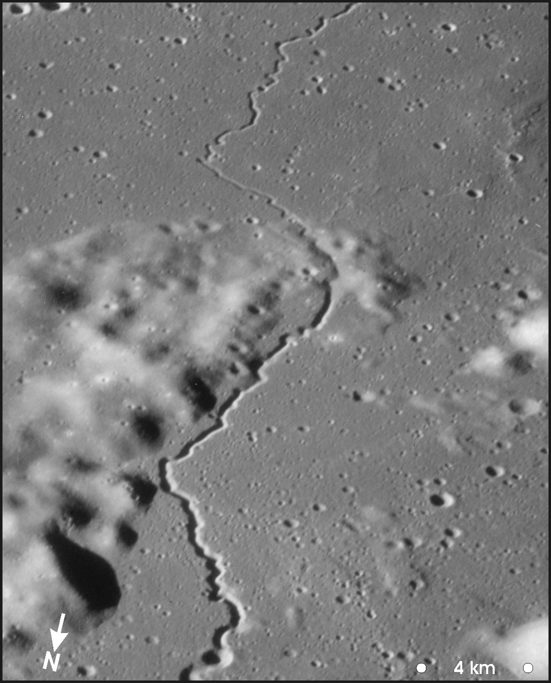
Figure 7: Oblique view of a lunar rille (part of the Rimae Herigonius system) that cross-cuts highland terrain located northeast of crater Gassendi [Greeley and Spudis, 1978] (Apollo 16 Hasselblad frame AS16-119-19170) [Leverington, 2006]. Scale is valid only in the bottom-right corner of the image. The rille crosscuts highlands at ~36.75 degrees W, 15.5 degrees S. Illumination is from the left.
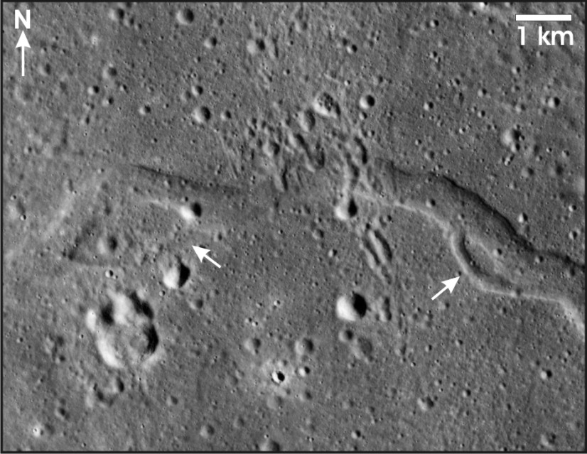
Figure 8: Streamlined islands (arrows) inside a lunar rille located north of Aristarchus Plateau, Oceanus Procellarum (at ~29 degrees 30’N, 46 degrees 30’W) [Leverington, 2004a]. This channel extends westward from a breach in the wall of crater Krieger [e.g., Carr, 1974; Leverington and Maxwell, 2004]. Illumination is from the right. Apollo 15 Panoramic frame 324.
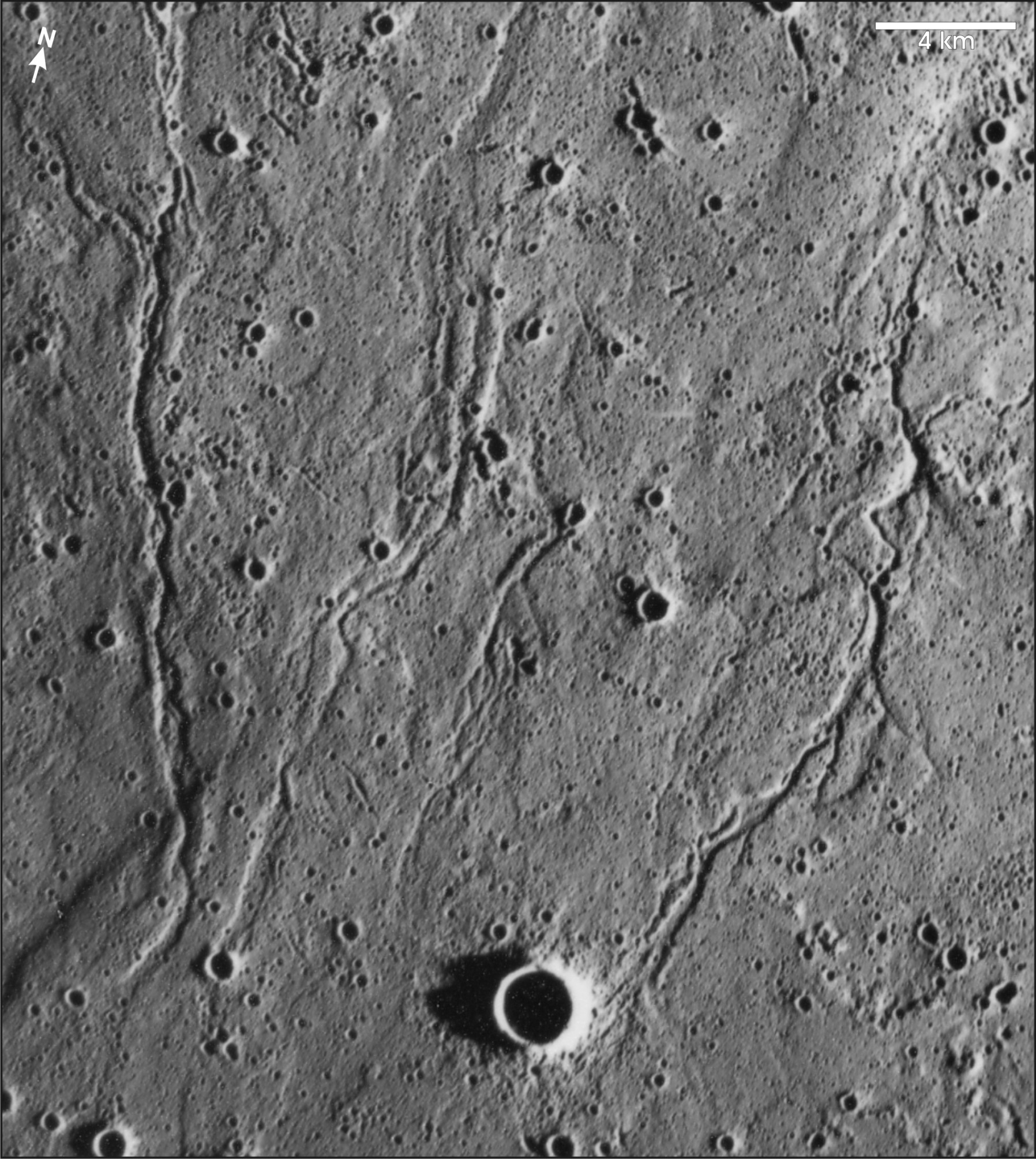
Figure 9: Anastamosing volcanic channels located in Mare Imbrium (~24 degrees N, 31 degrees W), northwest of lunar crater Euler [see also, e.g., Schaber, 1973] [Leverington, 2004a]. Illumination is from the right. Apollo 15 Metric frame AS15-M3-1701.
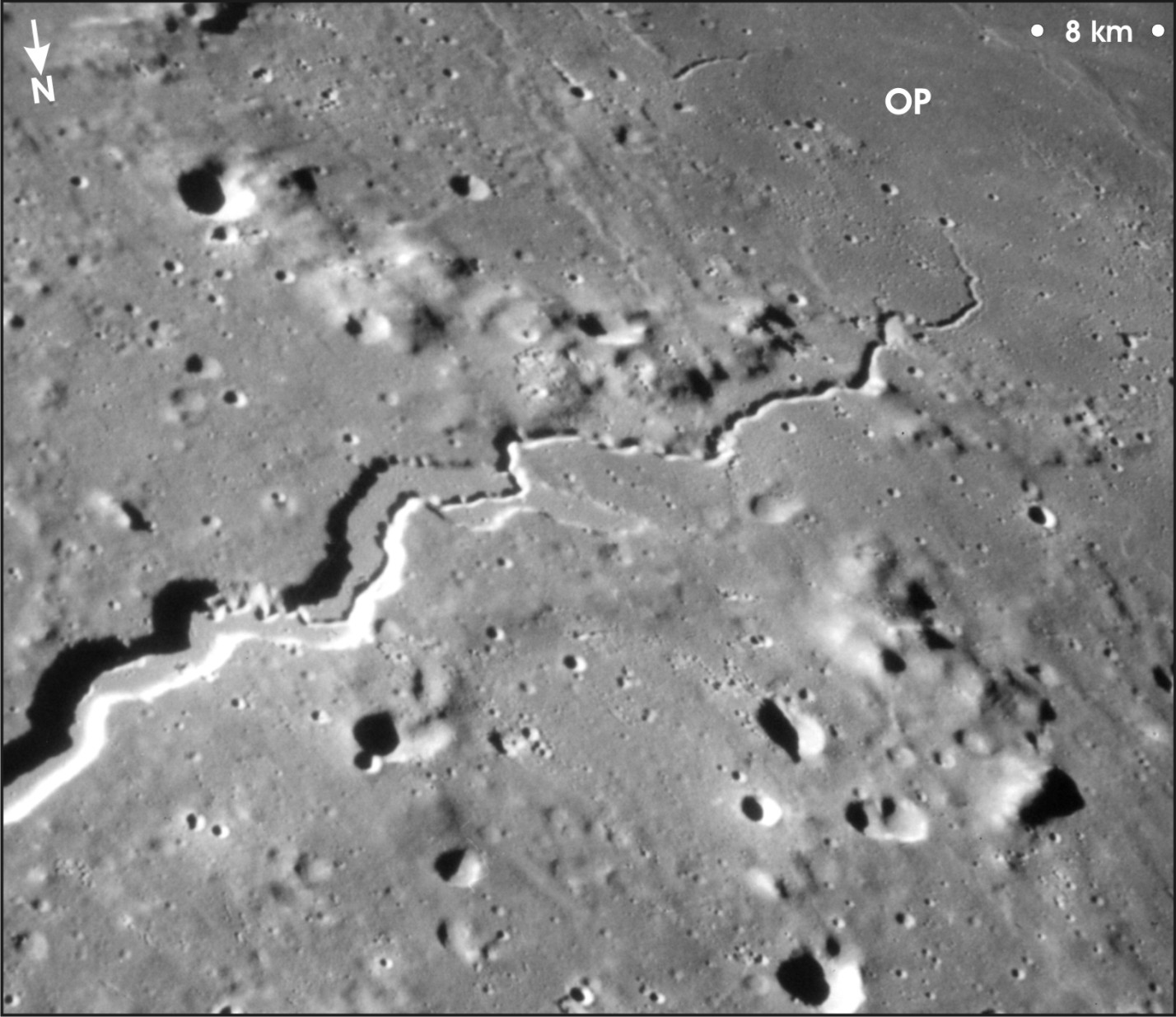
Figure 10: Oblique view of the distal valley and nested channel of lunar Vallis Schroteri (figure center at ~25 degrees N, 52 degrees 40’ W), which extend onto Oceanus Procellarum (OP) from a large topographic depression that marks the main channel source on the Aristarchus Plateau [Leverington, 2004a]. Scale is valid only in the upper-right corner of the image. Illumination is from the left. Apollo 15 Hasselblad frame AS15-93-12628.

Figure 11: Terraces in one of the channels of Rimae Prinz (~27 degrees N, 44 degrees 20’ W), located north of lunar crater Prinz [Leverington, 2004a]. Illumination is from the right. Apollo 15 Panoramic frame 318.
2 Outflow Channels of Mercury
Recent MESSENGER results [e.g., Head et al., 2011; Stockstill-Cahill et al., 2012; Hurwitz et al., 2013; Byrne et al., 2013] suggest the existence on Mercury of volcanic channels with maximum channel widths in excess of 30 km. Channels are in some cases associated with pit-like source features, teardrop-shaped hills, and distal lobate-margined smooth plains [Head et al., 2011].
Figure 12: Apparent volcanic outflow system on Mercury [Head et al., 2011].
3 Outflow Channels of Venus
The existence and diversity of volcanic channels on Venus were first recognized in images generated by the Magellan mission [Saunders and Pettengill, 1991]. These channels, believed to have formed through a variety of mechanisms involving both constructive and erosive processes, are widely associated with volcanic features such as coronae, shield volcanoes, and rift zones [e.g., Baker et al., 1992b; Komatsu et al., 1992, 1993; Gregg and Greeley, 1993; Komatsu and Baker, 1994]. Though many Venusian systems are readily classifiable as outflow channels, some channels are associated with flows that appear to head at or under the ejecta blankets of impact craters [e.g., Asimow and Wood, 1992; Chadwick and Schaber, 1993].
Many Venusian channels are relatively simple in form, consisting of long channels with few or no tributraries, and having general morphologies that are similar to those of simple sinuous lunar rilles [Baker et al., 1992b, 1997; Head et al., 1992; Komatsu and Baker, 1994] (see lunar section above). Simple channels on Venus generally head at topographic depressions, and have relatively constant widths of ~1 to 2 km and lengths of tens to hundreds of kilometers [Baker et al., 1992b, 1997; Head et al., 1992]. The longest recognized channel on Venus, located mostly on lava plains located north of Rusalka Planitia, has a total length of 6800 km [Baker et al., 1992b]. Features associated with simple channels on Venus include meander cutoffs, abandoned channel segments, and levees [Baker et al., 1992b; Head et al., 1992]. The meanders of simple Venusian channels are suggestive of modification of original flow patterns by erosional channel widening during lava flow [Komatsu and Baker, 1994]. As with their lunar counterparts, there are numerous examples of simple Venusian channels that cut across irregular topography, suggesting that formation of these channels involved erosive processes [e.g., Komatsu and Baker, 1994].
Complex channels, which in numerous cases possess large braided patterns that define streamlined islands, are also found on Venus [Baker et al., 1992b]. Many of these channels head at topographic depressions, and a minority of channels have large delta-like distributary systems at their mouths [Baker et al., 1992b]. A prominent complex Venusian channel, Kallistos Vallis, is located in the northern region of Lada Terra, east of Lavinia Planitia. Kallistos Vallis is over 1200 km long and up to 30 km wide, and heads at a collapse feature on the flank of a large volcanic construct [Baker et al., 1992b; Komatsu et al., 1993]. This collapse feature is morphologically similar to the regions of chaotic terrain that acted as sources for many outflow channels on Mars [Baker et al., 1992b] (see below).
Liquid water is unstable on Venus [e.g., Kargel et al., 1993], and although water may have been abundant very early in the planet’s history, it is only present today in trace amounts as water vapor [e.g., Donahue and Russell, 1997]. Partly on this basis, the channels of Venus are believed to have formed in the essential absence of water [Baker et al., 1992b]. The X-ray fluorescence and gamma-ray measurements made by seven Venera and Vega landers are consistent with mafic volcanic compositions such as tholeiitic basalt [e.g., Surkov, 1983; Surkov et al., 1987; Kargel et al., 1993; Fegley et al., 1997]. A volcanic origin for Venusian outflow systems is widely favored based on the volcanic nature of associated Venusian landforms, the character of the Venusian surface (including the absence of Venusian landforms suggestive of widespread aqueous surface runoff in the past), and environmental and geochemical considerations [e.g., Baker et al, 1992b, 1997; Nimmo and McKenzie, 1998].
Venusian channels are hypothesized to have formed by the flow of mafic or ultramafic silicate lavas, or possibly by the flow of lavas of exotic compositions such as sulfur or carbonatite [e.g., Baker et al., 1992b; Komatsu et al., 1993; Kargel et al., 1994]. Although some workers have hypothesized that formation of complex channels on Venus may have been a consequence of the planet’s high surface temperatures and of particular fluid chemistries such as liquid sulfur or ultramafic compositions, appeals to special rock chemistries and environmental conditions to justify the existence of Venusian channels may be unnecessary. A simpler interpretation of Venusian channels involves a recognition that basaltic lava, erupted in sufficiently large volumes and at sufficiently low viscosities, is capable of formation of large channels through processes that include erosion. This interpretation is consistent with measurements returned by the Venera and Vega landers [e.g., Surkov, 1983; Surkov et al., 1987; Kargel et al., 1993; Fegley et al., 1997], the seemingly basaltic nature of volcanic landforms on Venus [Head et al., 1992], and the nature of basaltic landforms on the Moon.
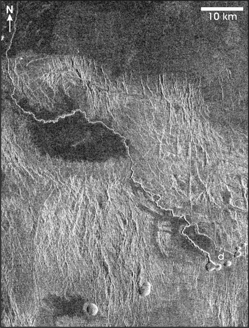
Figure 13: Simple Venusian rille located at ~2 degrees S, 273 degrees 18’ E, in Phoebe Regio [Leverington, 2004a]. Lava flows that formed this channel emerged from topographic depressions at d, flooding small basins and cutting northwestward across tesserae [Komatsu and Baker, 1994]. Microwave illumination is from the left. Magellan FMAP Left-Look SAR mosaic.
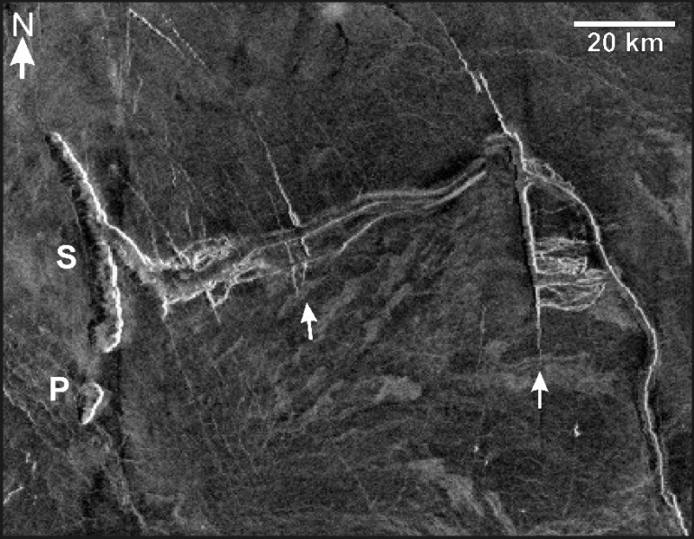
Figure 14: Belisama Vallis, a 350-km-long Venusian channel system located in Ishtar Terra, heads at a 42-km-long topographic depression (S) [Leverington, 2009]. An associated pit (P) is located south of the main depression, and the orientation of both depressions is approximately concentric with prominent structural features in the region (arrows). Further downslope, southeast of the depicted region, this system broadens to a width of ~10 km and anastamoses complexly about streamlined landforms with long axes of up to ~10 km [Baker et al., 1992b]. Magellan FMAP left-look Synthetic Aperture Radar (SAR) mosaic; the slight vertical offset of the rightmost quarter of the figure is a mosaic artifact. SAR illumination is from the left. Figure center: 22 degrees 08’ E, 50 degrees 30’ N.
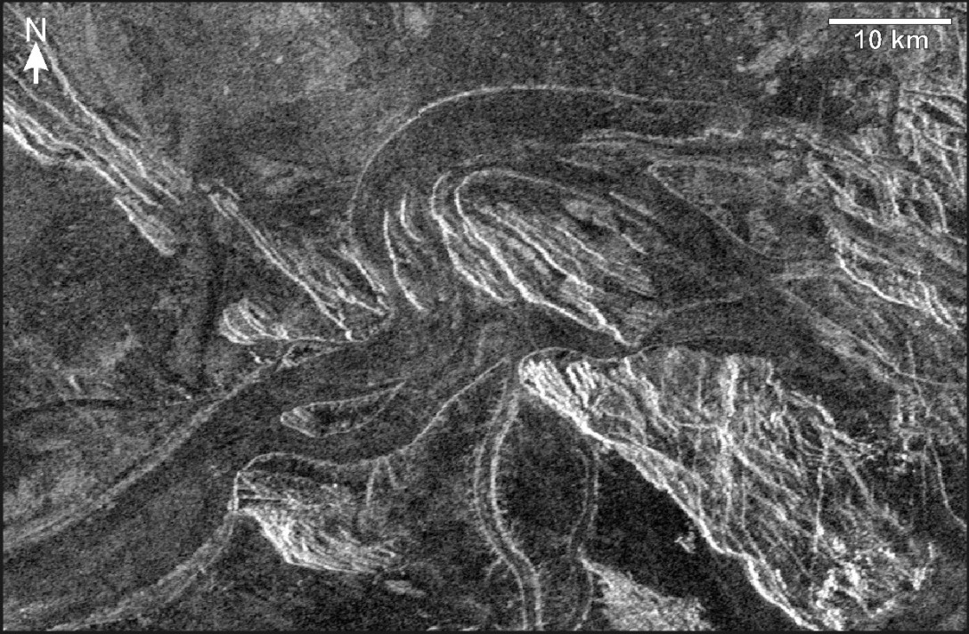
Figure 15: Examples of streamlined landforms of the largest Venusian outflow system, Kallistos Vallis [Leverington, 2009]. Located north of Lada Terra and southeast of Alpha Regio, this system is part of the Ammavaru volcanic complex and is over 1000 km long [Baker et al., 1992b, 1997; Komatsu et al., 1993]. The system heads in a region of chaotic terrain located northwest of the depicted area. In this figure, the channel extends downslope from bottom left to middle right. Magellan FMAP left-look SAR mosaic. SAR illumination is from the left. Figure center: 22 degrees 55’ E, 51 degrees 00’ S.
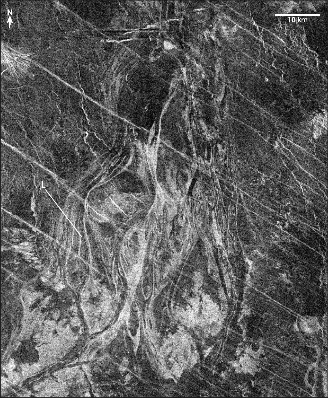
Figure 16: Magellan synthetic aperture radar image of a Venusian channel located northeast of Ozza Mons, eastern Aphrodite Terra [Leverington, 2007]. This channel, interpreted as volcanic, is characterized by complexly-anastamosing reaches that define numerous streamlined islands that are kilometers to tens of kilometers across; these islands appear to be erosional residuals [Komatsu et al., 1993]. Some lineations in the radar imagery (e.g., L) could correspond to channel lineations, the banks of inner channels, or channel terraces. Flow along this reach was from south to north (figure bottom to top). Magellan FMAP left-look Synthetic Aperture Radar (SAR) mosaic; microwave illumination is from the left. Figure center is at ~211 degrees 40’ E, 11 degrees 40’ N.
4 Outflow Channels of Mars
The outflow channels of Mars are mainly located equatorward of ~30 degrees latitude [Mars Channel Working Group, 1983], and are characterized by a variety of sizes, morphologies, ages, and relationships with surrounding terrain features [e.g., Masursky et al., 1977]. The largest outflow channel, Kasei Valles, has a length of ~3000 km, and maximum width of ~230 km.
The attributes of individual outflow channels are variable: some channels have features such as large tributaries or streamlined bedforms, whereas others do not; some channels originate from very broad regions, whereas others originate more locally [e.g., Milton, 1973; Masursky et al., 1977; Carr, 1981; Mars Channel Working Group, 1983; Tanaka and Chapman, 1990; Zimbelman et al., 1992; Baker et al., 1992a; Komatsu and Baker, 1997; Nelson and Greeley, 1999; Burr et al., 2002ab; see summaries in Leverington, 2004a, 2007, 2009, 2011].
The largest outflow channels typically commence abruptly and at full width in regions of chaotic terrain, and are associated with features such as streamlined islands [e.g., Baker, 1978; Baker and Kochel, 1978ab, 1979] and longitudinal grooves [e.g., Baker and Milton, 1974; Carr, 1979; Baker, 1978; Baker and Kochel, 1979]. Most of the largest outflow channels head in regions adjacent to Chryse Planitia [e.g., Mars Channel Working Group, 1983]. Smaller channels located elsewhere on Mars, such as Dao Vallis and Harmakhis Vallis in eastern Hellas [e.g., Crown and Greeley, 1993] and the channels of Elysium [e.g., Wilson and Mouginis-Mark, 2003], share many of the characteristics of the largest outflow channels, including abrupt commencement at topographic depressions and association with features such as streamlined islands.
The anastamosing reaches of some Martian outflow channels have previously been interpreted by many workers as evidence in support of aqueous origins [e.g., McCauley et al., 1972; Masursky, 1973; Milton, 1973]. On the basis of their strong morphological similarity to terrestrial features known to have been produced by catastrophic floods [see, e.g., McCauley et al., 1972; Milton, 1973; Baker and Milton, 1974; Baker, 1978], streamlined features of Martian outflow channels are widely believed to have formed by relatively rapid releases of large volumes of groundwater [e.g., Masursky, 1973; Milton, 1973; Baker and Milton, 1974; Masursky et al., 1977; Baker, 1978; Baker, 1979; Mars Channel Working Group, 1983; Baker, 2001; Coleman, 2003; Manga, 2004]. Aqueous origins for the outflow channels would be consistent with the confirmed modern presence of water ice at high latitudes [Kieffer et al., 1976], and the hypothesized development of older (Noachian) valley networks by aqueous processes [Craddock and Maxwell, 1993].
Minimum water volumes required for formation of the Martian outflow channels have been estimated by assuming volumetric sediment-to-water ratios of 40:60 [e.g., Komar, 1979, 1980; Carr, 1987; Tanaka and Chapman, 1990; Rotto and Tanaka, 1992; Williams et al., 2000; Leask et al., 2006, 2007]. For example, the estimated ~4-5 x 10⁶km3 of material removed during outflow channel development at the circum-Chryse channels has been used to suggest that a minimum water volume of ~6-7.5 x 10⁶ km3 must have been involved in channel incision, equivalent to a global ocean ~40-50 m deep [Carr, 1987, 1996, pp.63 and 165; Baker et al., 1992a, p.518]. Taking into account that it would be highly unlikely for water reservoirs to have existed only at the heads of channels in the circum-Chryse region, this volume has been previously extrapolated across the Martian surface to infer an equivalent water volume of a global ocean ~300-500 m deep [Carr, 1987, 1996, p. 165; Baker et al., 1992a, p.518; Baker, 2006, p.140]. Because an average sediment load of 40% is unrealistically high, such minimum estimates must be treated with caution [e.g., Carr, 1996; Clifford and Parker, 2001; Ghatan et al., 2005; Kleinhans, 2005; Andrews-Hanna and Phillips, 2007]; sediment-water ratios typical of terrestrial streams yield water volumes up to two or three orders of magnitude greater than those estimated under assumptions of high sediment loads [Komar, 1980; Harrison and Grimm, 2004; Ghatan et al., 2005; Kleinhans, 2005; Andrews-Hanna and Phillips, 2007]. Some estimates for development of the Martian outflow channels and associated landforms suggest minimum volumes equivalent to a global water body well in excess of 1 km deep [Carr, 1996, p.166], particularly if features such as thick cryospheric seals are hypothesized and if efficient recycling of water is not assumed.
Flow rates associated with hypothesized aqueous floods have been difficult to confidently estimate because key parameters such as flood depth are poorly constrained. Nevertheless, on the basis of expected flow conditions and empirical relations such as the scaled Manning equation [Komar, 1979; Wilson et al., 2004], discharge rates are estimated to have reached ~106 to 1010 m3/s [e.g., Carr, 1979, 1996; Komar, 1979; Baker, 1982; Robinson and Tanaka, 1990; Baker et al., 1991; Komatsu and Baker, 1997; Dohm et al., 2000; Burr, 2003; Head et al., 2003; Andrews-Hanna and Phillips, 2007; Harrison and Grimm, 2008; Mangold et al., 2008; Wilson et al., 2009]. The highest of these estimates are orders of magnitude larger than those of known terrestrial floods and are instead comparable to the rates of ocean currents such as the Gulf Stream [Baker, 2001, p.230, 2009c, p.25]. The corresponding flow velocities of Martian outflow events are predominantly estimated to have been ~4-60 m/s for assumed water depths of ~10-500 m [e.g., Baker et al., 1991; Carr, 1996; Head et al., 2003; Leask et al., 2006; Wilson et al., 2009], but maximum floodwater velocities during the largest events are estimated to have reached or exceeded 100 m/s [e.g., Komatsu and Baker, 1997].
Formation of Martian outflow channels by the sudden release of ponded surface waters has previously been hypothesized for numerous individual systems [e.g., McCauley, 1978; Robinson and Tanaka, 1990; McKenzie and Nimmo, 1999; Chapman and Tanaka, 2002; Harrison and Grimm, 2004, 2008; Harrison and Chapman, 2008]. However, regardless of the exact nature of water release, the relatively small volumes of basins at the heads of many systems strongly suggest that floodwaters would have necessarily been derived from much larger subsurface reservoirs [e.g., Carr, 1979, 1996; Clifford and Parker, 2001; Jakosky and Phillips, 2001; Burr et al., 2002a; Andrews-Hanna and Phillips, 2007]; in this perspective, areas of disturbance or collapse at the heads of outflow channels mark the locations of outbursts rather than the full lateral dimensions of subsurface reservoirs [Clifford and Parker, 2001; Andrews-Hanna and Phillips, 2007]. The high estimated discharge rates of flood events have suggested the need for highly porous and well-connected aquifer systems [Carr, 1979], with required porosities at 0-7 km depth of at least ~ 5-20% [e.g., Clifford, 1981; MacKinnon and Tanaka, 1989; Hanna and Phillips, 2005] and required permeabilities as great as ~ 10-6 and 10-7 m2 [Head et al., 2003; Montgomery et al., 2009; Wilson et al., 2009]. Permeabilities such as these are not typical of aquifers on the Earth, but are believed by some workers to have possibly been produced on Mars by widespread disturbance of the megaregolith by impacts during the heavy bombardment phase [e.g., Wilson et al., 2009]. Martian porosities in excess of 40% have been hypothesized for depths of ~2-7 km in regions substantially underlain by fractured and vesicular basalt units [Dohm et al., 2001]. Large increases in hydrologic connectivity are additionally hypothesized to have developed in the subsurface as a result of processes such as the dewatering of hydrous salts [Montgomery and Gillespie, 2005; Montgomery et al., 2009], gradual formation of caverns by hydrothermal processes [Rodriguez et al., 2003, 2005], or physical disruption of rock units during outburst events [Carr, 1996].
Though many uncertainties remain [Hanna and Phillips, 2005; Wang et al., 2006], a widely cited mechanism for development of Martian outflow events relies on the early pressurization of aquifers by the downward movement of freezing fronts [e.g., Carr, 1979, 2000; Clifford and Parker, 2001; Ghatan et al., 2005; Basilevsky et al., 2009]. Cooling of the Martian megaregolith, possibly linked to early reductions in interior heat flow or changes in surface conditions [Carr, 1979, 1996], is hypothesized to have gradually formed a ~4-km-thick global cryospheric seal that pushed underlying pore waters against low porosity materials at depths of >6 km [Carr, 1979, 2000; Wilson et al., 2009]. Periodic breaching of the ice-rich cryosphere is speculated to have been variously caused by igneous intrusions [e.g., Head et al., 2003; Wilson and Head, 2004], tectonic processes [e.g., Tanaka and Chapman, 1990; Tanaka and Clifford, 1993], impact events [Carr, 1979, 1996; Tanaka and Clifford, 1993], or the thickening of the cryosphere itself [Carr, 1979], ultimately leading to pressure-driven outbursts capable of supplying peak channel discharges up to or exceeding ~109 m3/s [e.g., Carr, 1979, 1996; Robinson and Tanaka, 1990; Masson et al., 2001; Wilson et al., 2009].
Today, atmospheric temperatures and pressures at the surface of Mars vary from ~140 to 220 K and from ~1 to 14 mbar, respectively, with corresponding ground temperatures ranging from ~160 to 290 K [e.g., Fanale and Cannon, 1979; Carr, 1996; Jakosky and Phillips, 2001; Forget, 2007]. Only trace amounts of water are present in the tenuous Martian atmosphere, with the column abundance of atmospheric water mainly ranging from ~1 to 100 precipitable microns [e.g., Jakosky and Farmer, 1982; Jakosky, 1985; Carr, 1996]. Although exceptions may exist [Haberle et al., 2001; Rennó et al., 2009], the temperature and pressure conditions that prevail today at the Martian surface should render liquid water unstable at any latitude and should make exposed water ice unstable within ~30 degrees of the equator [e.g., Ingersoll, 1970; Farmer and Doms, 1979; Clifford and Hillel, 1983; Carr, 1996; Jakosky and Phillips, 2001; Bryson et al., 2008]. Modern environmental conditions thus inhibit the flow or accumulation of liquid water at the surface, but hypothesized aqueous outflow events are believed by some workers to have been sufficiently rapid and voluminous to have been possible even under conditions similar to those of today [e.g., Wallace and Sagan, 1979; Carr, 1983, 1996]. The outflow record of Mars has nevertheless been cited as possible evidence for the past occurrence of warmer and wetter conditions, either because channel formation was triggered by periods of warming or because the channel outbursts themselves contributed to changes in climatic conditions [e.g., Sagan et al., 1973; Toon et al., 1980; Baker et al., 1991; Kasting, 1991; Forget and Pierrehumbert, 1997; Gulick et al., 1997; Baker, 2001; Head et al., 2001; Masson et al., 2001; Pacifici et al., 2009]. Development of the outflow channels has been linked by some workers to the dynamics of a global hydrological cycle driven at least partly by internal heat sources. In this view, episodes of aqueous outflow activity lead to formation of short-lived oceans, the release of large stores of H2O and CO2 into the atmosphere, and geologically brief periods of greenhouse warming [Baker et al., 1991; Baker, 2001].
Regardless of the climatic conditions under which hypothesized outflow events took place, the enormous volumes required for incision of individual outflow channels are now generally believed to have necessitated the occurrence of multiple flood events [e.g., Baker et al., 1991; Manga, 2004; Andrews-Hanna and Phillips, 2007]. For hypotheses involving pressurized aquifers, the termination of each flood event should have been followed by resealing of the cryosphere and recharge of the local aquifer [Carr, 1979, 1996; Clifford, 1993]. Recent work has suggested that rapid decreases in aquifer pressurization during outflow events would have greatly limited the sizes of individual floods, possibly requiring the occurrence of dozens to thousands of relatively small flood events to complete development of individual outflow systems [Manga, 2004; Andrews-Hanna and Phillips, 2007; Harrison and Grimm, 2008]. Recharge of southern hemisphere aquifers is envisioned by some workers to have taken place by the freezing of terminal water bodies produced by outflow events, transfer of a proportion of this frozen water to the south polar ice cap through sublimation and subsequent freezing at high latitudes, and recharge of southern aquifers by infiltration and lateral migration of meltwaters produced through basal melting of the southern ice cap [Clifford, 1987, 1993; Carr, 2000; Clifford and Parker, 2001]. In this view, the processes involved in aquifer recharge are important components of a global hydrological cycle [e.g., Clifford, 1993; Clifford and Parker, 2001]. Based on the possible past existence of glaciers near the summits of shield volcanoes, a similar but more localized set of processes has been hypothesized for the Tharsis region [e.g., Russell and Head, 2007].
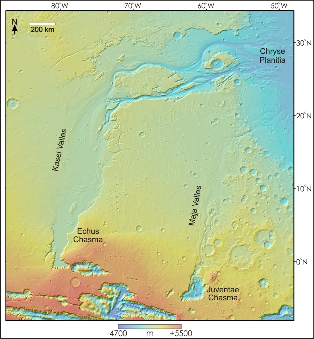
Figure 17: Among the most prominent outflow systems on Mars are Kasei Valles and Maja Valles [figure modified and corrected from Leverington, 2011]. These systems are located north of Valles Marineris in the southwestern part of the circum-Chryse region. Kasei Valles commences at a topographic depression located immediately west of Echus Chasma and extends more than 3000 km downslope, ultimately fading into the ridged plains of Chryse Planitia [e.g., Robinson and Tanaka, 1990; Chapman et al., 2010]. The Maja Valles system heads at Juventae Chasma and similarly extends northward into Chryse Planitia [e.g., Baker and Kochel, 1979; Chapman et al., 2003]. Mars Orbiter Laser Altimeter (MOLA) elevation data superimposed on shaded relief [topography after Smith et al., 2003].
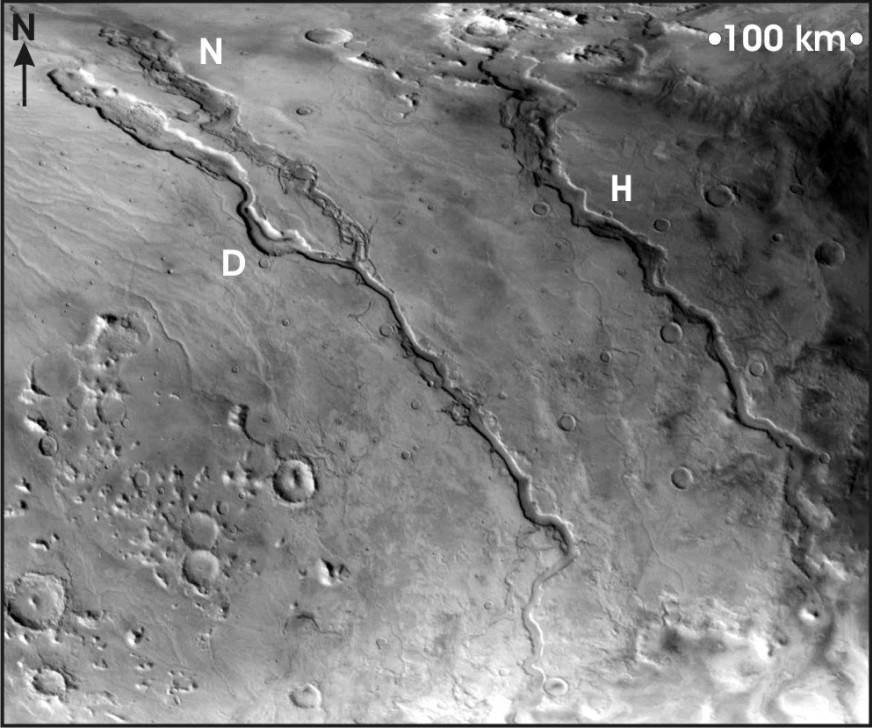
Figure 18: Oblique view of Martian outflow channels Dao Vallis (D) and Harmakhis Vallis (H), located in eastern Hellas on the flanks of Hadriaca Patera and Tyrrhena Patera [Leverington, 2004a; see also, e.g., Crown and Greeley, 1993]. Niger Vallis (N) joins Dao Vallis near the center of the figure (figure center is at ~271 degrees 18’W, 38 degrees S). Scale is valid only in the upper-right corner of the image. Illumination is from the left. Mars Orbiter Camera wide-angle frame M1900826.
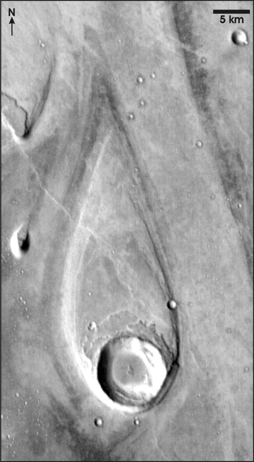
Figure 19: Streamlined island located at the mouth of Martian outflow channel Ares Vallis, at ~20 degrees 12’ N, 31 degrees 15’ W [Leverington, 2004a]. Illumination is from the left. Themis daytime thermal frame I02560002.
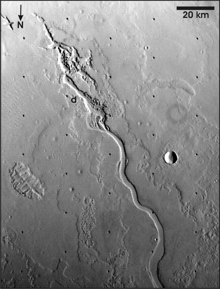
Figure 20: Part of Hrad Vallis, a Martian outflow channel located on the distal flanks of Elysium Mons, at ~34 degrees N, 218 degrees 15’ W [Leverington, 2004a; see also, e.g., Wilson and Mouginis-Mark, 2003]. The channel commences abruptly at a complex topographic depression (d). Illumination is from the right. Viking Orbiter frame 541A10.
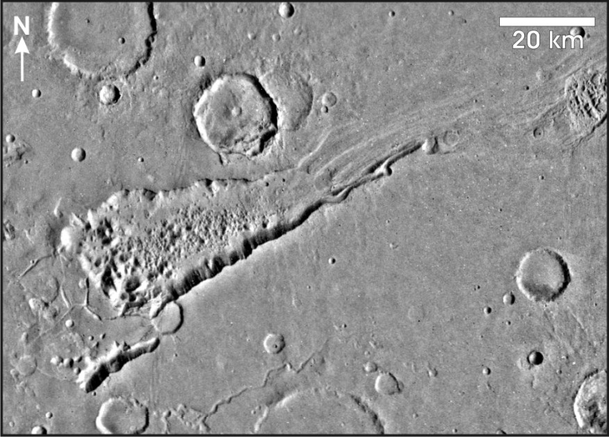
Figure 21: Aromatum Chaos, Mars (~43 degrees 8’ W, 1 degree 7’ S) [Leverington, 2004a]. The outflow channel feeds into Hydroates Chaos, ultimately extending onto the plains of Chryse Planitia through Simud Vallis and Tiu Vallis. Illumination is from the right. Viking MDIM mosaic.
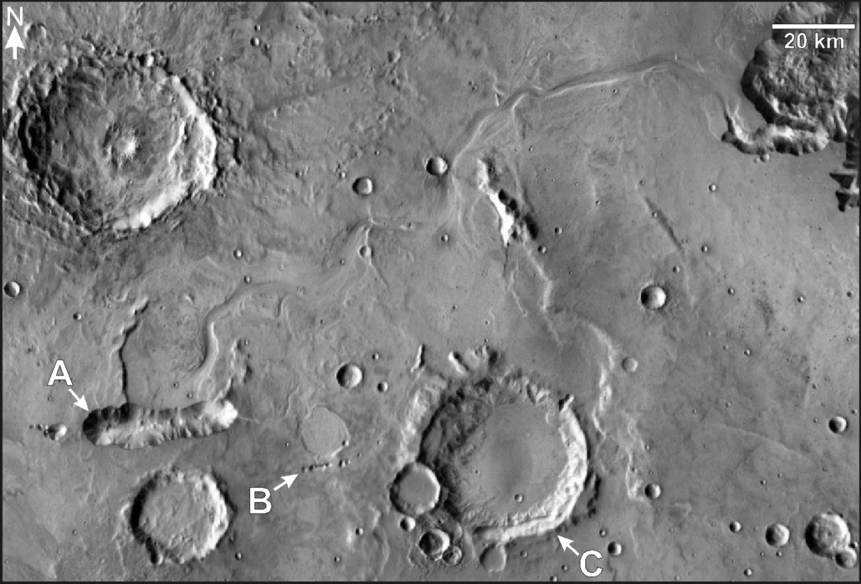
Figure 22: The Allegheny Vallis and Walla Walla Vallis systems are relatively small Martian outflow channels that head at elongate topographic depressions (A and B, respectively), and extend northward and eastward to the western rim of Ganges Chasma (top right) [Leverington, 2009; see also, e.g., Coleman et al., 2007; Komatsu et al., 2009]. A third elongate depression (C) is located along the southern interior rim of a 40-km-diameter impact crater; effusion of fluids from this depression may have played a role in development of the shallow lowlands that extend northward from the impact crater to Allegheny Vallis. THEMIS daytime-infrared mosaic courtesy of Arizona State University. Figure center: 53 degrees 55’ W, 9 degrees 20’ S.
3.1 Possible Issues with Assumed Megaregolith Properties
Determination of realistic mechanisms by which aqueous floods might have occurred has been problematic [e.g., see summaries in Leverington, 2004a, 2007, 2009, 2011]. It has been recognized, for example, that the volumes of water that could have been produced solely from regions of chaos at the heads of many Martian channels would likely have been insufficient to form the outflow channels, necessitating multiple releases (dozens to thousands) each involving large volumes of water [e.g., Baker, 1982; Manga, 2004]. In order to have taken place, these releases would seem to have required the existence of unusual conditions at and near the Martian surface, such as 1) a global cryosphere that could be locally and repeatedly breached and re-sealed; and 2) confined regional aquifers that could supply and convey large amounts of water under high artesian pressures to breached areas [e.g., Carr, 1979; Clifford, 1993; Clifford and Parker, 2001].
Mean annual discharge at the mouth of the Amazon River is ~200,000 m3/s, a volume equivalent to ~10% of the river input to terrestrial oceans [Richey et al., 1989]. Peak discharge rates of ~106-107 m3/s, roughly equivalent to ~5 to 50 Amazon Rivers flowing simultaneously, have been predicted for development of numerous relatively small outflow systems on Mars, including Athabasca Valles and Mangala Valles [e.g., Komar, 1979; Burr et al., 2002a; Head et al., 2003; Leask et al., 2006, 2007; Mangold et al., 2008]. Still higher peak discharge rates of ~108-1010 m3/s, equivalent to ~500 to 50,000 Amazon Rivers flowing simultaneously, have been predicted for large outflow channels such as Kasei Valles and Ares Vallis [Robinson and Tanaka, 1990; Komatsu and Baker, 1997; Dohm et al., 2000; Baker, 2001; Masson et al., 2001; Harrison and Grimm, 2008] [see summary in Wilson et al., 2009]. The limited sizes of basins at the heads of many outflow systems and the abundance of geomorphological evidence indicating flow from the subsurface have favored channel interpretations involving voluminous outbursts from deep aqueous reservoirs [e.g., Carr, 1979, 1996; Clifford and Parker, 2001; Jakosky and Phillips, 2001; Burr et al., 2002a; Andrews-Hanna and Phillips, 2007]. Such outbursts imply extraordinarily high permeabilities in the upper ~7 km of the Martian megaregolith [e.g., Carr, 1996; Head et al., 2003; Wilson et al., 2009].
Quantitative models of Martian outburst events have utilized a wide range of estimates for flow rates, porosities, and permeabilities. Typical parameterizations include maximum outburst rates of ~106 m3/s [Komar, 1979; Burr et al., 2002a; Mangold et al., 2008], porosities of ~5-20% at depths of 0-7 km [e.g., Clifford, 1981; MacKinnon and Tanaka, 1989; Hanna and Phillips, 2005] and high but plausible regional permeabilities of ~10-15 to 10-9 m2 [e.g., Andrews-Hanna and Phillips, 2007; Harrison and Grimm, 2008]. However, recent work has suggested that the permeabilities required to sustain estimated peak discharge rates should instead approach much higher values on the order of ~10-7 to 10-6 m2 [Head et al., 2003; Wilson et al., 2009]. Though permeabilities of ~10-7 m2 correspond to those expected of highly porous gravels and are therefore strictly feasible, they are also ~7 orders of magnitude larger than are typical at the regional scale for terrestrial aquifers [e.g., Head et al., 2003; Wilson et al., 2009].
Even assuming the existence on Mars of vast aquifers of hemispheric or global extent and characterized by high porosity and permeability, the aqueous hypothesis for development of the outflow channels cannot account for the relatively high elevations of the heads of the largest outflow systems of Mars [e.g., Leverington, 2009, 2011]. Given the widespread capacity for volcanism, structural processes, and impacts to have breached hypothesized cryospheric caps across all Martian elevations during the Hesperian and Amazonian, a cryospherically-confined and well-connected aquifer system with dynamics driven partly or entirely by hydrostatic pressures should have favored outbursts at relatively low elevations rather than at elevated terrain located deep within the southern highlands [Carr, 2002].
3.2 Mineralogical Considerations
Because the mineral olivine is readily altered in the presence of water, it is not clear that the existence of pristine olivine-rich units along Martian outflow channels [Rogers et al., 2005; Koeppen and Hamilton, 2008] is consistent with aqueous models of channel development involving the long-term presence of massive groundwater stores and water-saturated cryospheric seals, and recurring releases of large volumes of water to the surface [e.g., see summaries in Leverington, 2009, 2011]. Indeed, olivine-rich units spanning a wide range of ages are preserved across much of the surface of Mars [e.g., Koeppen and Hamilton, 2008]. Small grains of olivine should be especially susceptible to alteration by water, but are nevertheless known to comprise a significant fraction of the sediment cover of locales including the Spirit landing site at Gusev Crater [e.g., Morris et al., 2004]. The widespread preservation of olivine on Mars, and the restriction of mineralogical evidence for limited "wet" surface processes mainly to the earliest stages in the planet’s history [e.g. Chevrier and Mathe, 2007; Koeppen and Hamilton, 2008], bring aqueous interpretations of the Martian outflow channels further into question [see discussion in Leverington, 2011].
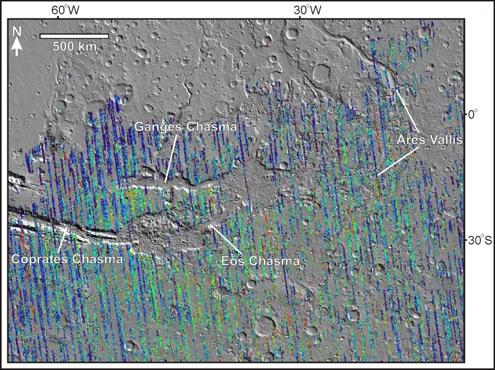
Figure 23: Olivine-rich units that are distributed across the southern hemisphere of Mars are prominently exposed at, and in the vicinity of, large outflow channels such as Ares Vallis [Rogers et al., 2005; Koeppen and Hamilton, 2008; figure from Leverington, 2011]. In this map of the eastern Valles Marineris region, total olivine abundance for well-exposed sites is plotted on a map of shaded relief. Estimated total olivine abundances range from low values of ~1 to 7% (blue) to moderate values of ~10 to 20% (green to yellow) to high values of ~30% (red). Abundance data were plotted using the Java Mission-planning and Analysis for Remote Sensing (JMARS) system and were originally generated from Thermal Emission Spectrometer (TES) data by Koeppen and Hamilton [2008]. Data are not available for sites with albedo values >0.2 (i.e., sites with substantial dust cover).
3.3 Limited Correspondence Between Martian Outflow Channels and Terrestrial Aqueous Analogs
Aqueous interpretations of the Martian outflow channels are partly based on recognized similarities between the characteristics of these systems and those of terrestrial diluvial landscapes. However, direct correspondence between Martian outflow systems and proposed terrestrial analogs is notably limited. For example, although depositional fluvial features such as longitudinal bars, eddy bars, and giant current ripples are widespread in the Channeled Scabland [Bretz et al., 1956; Baker, 1978b, 2009a], no obvious examples of such landforms are known at the Martian outflow channels. Correspondence between the terrestrial and Martian landscapes is instead mostly or completely confined to erosional features such as quadrilateral residuals, hanging valleys, and cataracts [Baker and Milton, 1974; Baker, 1978b; Ghatan et al., 2005; Leverington, 2007]. Accumulation of sedimentary flood deposits in the Channeled Scabland took place in a wide range of environments such as those located along the floors of major and minor channel reaches, in the lees of flow obstacles, and in zones that variously experienced slackwater and high turbulence conditions [e.g., Bretz et al., 1956; Benito and O’Connor, 2003]. Given the millions of cubic kilometers of material removed during outflow channel development on Mars [Carr, 1987, 1996] and given hypothesized sediment loads of up to 40% [e.g., Komar, 1979, 1980; Carr, 1987; Tanaka and Chapman, 1990; Rotto and Tanaka, 1992; Williams et al., 2000; Leask et al., 2006, 2007], the absence of prominent fluvial deposits analogous to those of the Channeled Scabland is conspicuous. Although candidate fluvial deposits continue to be routinely identified at Martian outflow channels [e.g., possible diluvial boulder trains, giant eddy bars, pendant bars, and giant transverse dunes; Burr et al., 2002b; Burr and Parker, 2006; Carling et al., 2009; Pacifici et al., 2009], unambiguous examples of fluvial deposits remain frustratingly difficult to identify [e.g., Greeley et al., 1977; Baker and Kochel, 1979; Mars Channel Working Group, 1983; Tanaka, 1997; Wilson and Mouginis-Mark, 2003; Ghatan et al., 2005; Burr and Parker, 2006; Leverington, 2007; Carling et al., 2009]. Notably, though many uncertainties remain, numerous channel features once believed to be excellent candidates for depositional fluvial units [e.g., landforms at Mangala Valles, Athabasca Valles, and Kasei Valles; Craddock and Greeley, 1994; Burr et al., 2002b; Williams and Malin, 2004; Burr, 2005] have recently been interpreted by some workers instead as units likely formed by scour or by processes related to volcanism [e.g., Ghatan et al., 2005; Leverington, 2007, 2009; Mangold et al., 2009; Jaeger et al., 2010]. A major group of diluvial landforms, prominent sedimentary units of fluvial origin, might not exist along the outflow channels of Mars.
The terminal basins of Martian outflow channels similarly appear to lack clear examples of aqueous sedimentary deposits. Large bodies of water are hypothesized to have pooled at the surface of Mars as a consequence of aqueous development of the outflow channels [e.g., Baker et al., 1991; Scott et al., 1992; Parker et al., 1993; Moore et al., 1995; Clifford and Parker, 1999, 2001; Baker, 2001; Ivanov and Head, 2001; Masson et al., 2001; Harrison and Chapman, 2008; Dohm et al., 2009], but strong supporting evidence for the past existence of these water bodies has not yet been identified. For example, the distal parts of the Martian outflow channels lack deltas, and instead typically fade into the extensive plains that characterize most terminal basins [e.g., Schonfeld, 1977a, 1979a; Greeley et al., 1977; Cutts et al., 1978; Baker et al., 1992a; De Hon, 1992; Carr, 1996; Burr et al., 2002b]. Compelling examples of strandline features are similarly lacking for these terminal basins. For example, hypothesized shoreline zones [e.g., Edgett and Parker, 1997; Clifford and Parker, 2001; Webb, 2004] appear to lack convincing examples of sedimentary features such as beaches, barrier ridges, and spits [Malin and Edgett, 1999; Ghatan and Zimbelman, 2006]. Some of the most extensive shoreline candidates [e.g., Parker et al., 1989, 1993; Edgett and Parker, 1997] are also problematically characterized by variations in elevation of up to thousands of meters [Head et al., 1998, 1999].
Might the nature of hypothesized aqueous outflow environments have been incompatible with development of prominent deltas and shoreline features? The apparent absence of such landforms has been attributed to factors including the rapidity with which hypothesized flood events took place [e.g., Irwin et al., 2004], the influence of low channel slopes on sediment deposition [Ivanov and Head, 2001], and the susceptibility of sedimentary landforms to weathering and erosion [e.g., Ghatan and Zimbelman, 2006]. Deposition of terminal sedimentary units by turbidity currents, possibly related to hyperpycnal flow (i.e., deep flow of relatively dense fluids into a standing water body) associated with emplacement of large debris flows, is hypothesized as a means by which development of deltas might have been inhibited in favor of wider sediment distribution [Tanaka, 1999; Komatsu and Ori, 2000; Ivanov and Head, 2001]. Might units such as the Vastitas Borealis Formation, a deposit that mantles parts of the northern plains and is interpreted to have formed under marine conditions [e.g., Fuller and Head, 2002; Kreslavsky and Head, 2002; Baker, 2006], have accumulated through the action of such mechanisms? Emplacement of sedimentary units over wide areas is considered plausible by some workers if, for example, fine sediments were hyperconcentrated in outflow waters [e.g., Kleinhans, 2005]. It is not clear, however, that marine interpretations of units such as the Vastitas Borealis Formation are consistent with the ubiquitous association of these units with meter-scale boulders [McEwen et al., 2007].
The mouths of several major outflow systems were directly investigated by the Viking 1, Mars Pathfinder, and Spirit spacecrafts. The Viking 1 landing site is located on the basaltic and wrinkle-ridged plains of southwestern Chryse Planitia, near the mouths of Kasei Valles and Maja Valles [Carr et al., 1976; Greeley et al., 1977]. This site is characterized by aeolian drifts [Mutch et al., 1976] and rocks with a size-frequency distribution similar to that of the Surveyor 7 landing site on the Moon [Moore et al., 1977]. Large angular rocks present at this site are interpreted as probable impact debris [Greeley et al., 1977]. Also located in Chryse Planitia, the Mars Pathfinder landing site is situated in the southern part of the basin near the confluence of the mouths of Ares Vallis and Tiu Vallis [Nelson and Greeley, 1999]. The Pathfinder landing site broadly resembles the Viking 1 landing site [Rover Team, 1997] and is similarly characterized by abundant aeolian features [Greeley et al., 1999] and rocks of a wide range of sizes [Golombek et al., 1999a]. Most rock spectra collected at the Pathfinder site are consistent with mafic, and possibly intermediate, rock compositions [McSween et al., 1999]. The subrounded, perched, or imbricated character of some rocks at the Pathfinder site, and the possible presence of conglomerates, has been interpreted as consistent with emplacement of site materials by catastrophic floods [Rover Team, 1997; Golombek et al., 1999ab; Ward et al., 1999]. However, as with the Viking 1 site, fluvial interpretations are not considered conclusive [e.g., Chapman and Kargel, 1999; Tanaka, 1999; Ward et al., 1999]. The Spirit landing site is located at the mouth of Ma’adim Vallis and is also characterized by an abundance of aeolian features and rocky materials, with plains rocks mainly comprised of primitive olivine-bearing basalts [Arvidson et al., 2006]. Though associated Columbia Hills materials have been aqueously altered and are relatively enriched in phases such as goethite, hematite, and nanophase iron oxides [Arvidson et al., 2006], the preserved mineralogy of surface materials in the region clearly indicates that physical weathering processes have generally dominated over chemical processes [Morris et al., 2004]. Importantly, none of the characteristics of the Viking 1, Mars Pathfinder, and Spirit landing sites require development through catastrophic aqueous flooding [e.g., Arvidson et al., 1989; Chapman and Kargel, 1999; Ward et al., 1999]. Indeed, the basic attributes of all three sites are consistent with those expected of volcanic plains subjected to limited chemical alteration and substantial disruption by impacts.
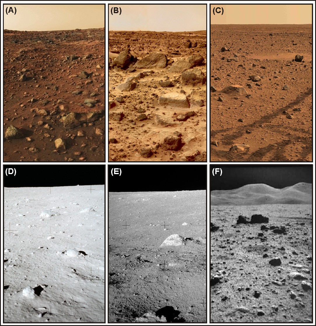
Figure 24: The mouths of outflow systems on Mars have been visited by three spacecraft: Viking 1 landed at a site in Chryse Planitia near the mouths of Kasei Valles and Maja Valles (A), Mars Pathfinder landed at a site in Chryse Planitia near the mouths of Ares Vallis and Tiu Vallis (B), and the Spirit rover landed at Gusev crater near the mouth of Ma’adim Vallis (C). Though widely hypothesized as the sites of catastrophic outflow events [e.g., Rover Team, 1997], the basic attributes of all three sites are arguably consistent with those expected of volcanic plains subjected to limited chemical alteration and substantial disruption by impacts [e.g., Arvidson et al., 1989]. The disrupted nature of the surface units of these sites is analogous to that of lunar volcanic plains visited during the Apollo program: Apollo 11 at Mare Tranquillitatis (D), Apollo 12 at Mare Cognitum (Oceanus Procellarum) (E), and Apollo 15 at Palus Putredinus (Mare Imbrium) (F) [Leverington, 2011]. Apollo image numbers: AS11-40-5940; AS12-48-7047; AS15-82-11175, respectively.
Hypotheses for the catastrophic aqueous development of Martian outflow systems are further weakened by the absence of satisfactory analog processes for the sudden release of large volumes of water from the subsurface [Leverington, 2007, 2009, 2011]. Although terrestrial landscapes such as the Channeled Scabland of Washington and the flood systems of the Mongolian plateau have been cited as a possible analogs to the terrain that characterizes outflow systems on Mars [e.g., Baker and Milton, 1974; Sharp and Malin, 1975; Komatsu et al., 2004; Andrews-Hanna and Phillips, 2007], the mechanisms of formation of terrestrial systems may offer little in the way of insight into the root causes of outflow-channel formation on Mars [Leverington, 2007]. Whereas the Martian outflow systems developed as a result of voluminous flow from the subsurface, the widely-cited landforms of the Channeled Scabland formed in response to entirely different processes related to the release of floodwaters from an ice-dammed lake [e.g., Bretz et al., 1956; Baker, 1978a; Smith, 1993]. In the near term, substantial progress in our understanding of Martian outflow systems may depend upon identification of genuine analog processes to those that initiated development of these systems [see discussion in Leverington, 2011].
Are there viable solar system analogs for the aqueous processes widely hypothesized to have led to development of the Martian outflow channels? Among the best available candidates may be those linked to development of large terrestrial springs and mud volcanoes [e.g., Leverington, 2011]. For example, aquifer circulation driven by hydraulic head and influenced by inclined strata has led to development of the Dalhousie Mound Spring complex of Australia, one of the largest groundwater discharge landforms on Earth [Clarke and Stoker, 2003; Clarke et al., 2007]. Terrestrial mud volcanoes, in contrast, commonly form in association with mud diapirs in regions of relatively high petroleum potential, with expulsion of mud and hydrocarbons typically forming crater-like features, hummocky mud flows, and small cones [e.g., Milkov, 2000]. Terrestrial mud volcanoes mainly form in marine environments, but prominent among subaerial examples is a feature that formed in Java as a result of drilling-induced processes related to petroleum exploration operations [Mazzini et al., 2007; Davies et al., 2008]. Unfortunately, the availability of terrestrial analogs such as these has not led to major advances in our understanding of outflow systems on Mars, in part because associated processes are inconsistent with the volumes and rates of flow inferred to have been required in development of the Martian systems. The processes that drive groundwater flow at terrestrial features such as springs and mud volcanoes are subject to the same permeability-related limitations that affect all other candidate processes involving the movement of fluids through porous media, and it is therefore not surprising that the average discharge rates produced at associated landforms are commonly no greater than several cubic meters per second [e.g., Clarke and Stoker, 2003; Mazzini et al., 2007].
3.4 Contradictions in Water Inventories
From a theoretical standpoint, virtually all of the original water content of Mars should have reacted with iron and other metallic phases to produce oxides and large quantities of hydrogen gas [e.g., Dreibus and Wänke, 1985, 1987]. Today, the bulk water content of the planet should consist of the vestiges of this early water, along with water contributed through processes such as the surface impact of volatile-rich bodies [e.g., Anders and Owen, 1977]. The largest confirmed modern reservoirs of water on Mars are the perennial ice caps and the near-surface stores that are distributed across middle to high latitudes [e.g., Kieffer et al., 1976; Clifford and Hillel, 1983; Smith et al., 1999; Seibert and Kargel, 2001; Boynton et al., 2002; Feldman et al., 2003; Mangold, 2005; Smith et al., 2009; Dundas and Byrne, 2010; Zenetti et al., 2010]. Although the minimum total volume of these reservoirs is estimated to be ~3 x 10⁶ km3 [Christensen, 2006], the modern Martian surface environment is extraordinarily dry. Liquid water is not stable anywhere at the planet’s surface, and exposed water ice is unstable at middle to low latitudes [e.g., Ingersoll, 1970; Farmer and Doms, 1979; Clifford and Hillel, 1983; Carr, 1996; Jakosky and Phillips, 2001].
The shergottite, nakhlite, and chassignite (SNC) meteorites are basalts or basaltic cumulates that are believed to have originated as subsurface components of the Martian crust and mantle, and therefore represent direct sources of information regarding the geochemistry of Mars [e.g., McSween, 1994; Treiman et al., 2000; Halliday et al., 2001]. The shergottites are notable among the SNC meteorites for possessing reflectance properties similar to those that characterize much of the Martian surface [e.g., McSween, 1994; Mustard et al., 1997, 2005]. As a group, the SNC meteorites are generally very dry; and although limited aqueous alteration is implied by the presence of minerals such as amphibole and gypsum [e.g., Bunch and Reid, 1975; Gooding et al., 1990; Karlsson et al., 1992; McSween and Harvey, 1993; McSween, 1994; Treiman et al., 2000; Bridges et al., 2001], many of the shergottites show evidence for having formed in essentially water-free environments [e.g., Carr, 1986; Wänke and Dreibus, 1994; Norman, 1999; Kiefer, 2003]. Typical bulk water contents of the SNC meteorites are only ~130 to 350 ppm, whereas terrestrial oceanic basalts commonly fall within the range of 1500-6000 ppm [Carr and Wänke, 1992; McSween and Harvey, 1993; Carr, 1996].
If the magmas that formed the SNC meteorites did not lose substantial amounts of water during ascent toward the surface [McSween et al., 2001], their geochemical characteristics suggest a low abundance of water on Mars relative to the Earth [McSween, 1994; Wänke and Dreibus, 1994]. On the basis of the compositions of the SNC meteorites and the modern Martian atmosphere, the early water content of Mars is estimated to have been equivalent to a global layer of ~6 to 200 m thickness, only a proportion of which would have been outgassed to the near-surface environment [Anders and Owen, 1977; Pollack and Black, 1979; Squyres, 1984; Dreibus and Wänke, 1985, 1987; Carr, 1987; Owen et al., 1988; McSween and Harvey, 1993; McSween, 1994]. The model of Scambos and Jakosky [1990] suggests a much wider range of possible Martian bulk water abundances (~90 to 3000 m), but restricts the amounts of outgassed water to an equivalent layer of only tens of meters thickness. The model of Lunine et al. [2003] suggests a similarly wide range in possible bulk water content (~600 to 2700 m), but proposes that a much higher proportion of water was outgassed (~50%). Recognized modern water reservoirs of Mars [Smith et al., 1999; Masson et al., 2001; Christensen, 2006] are approximately equivalent to a global layer with a thickness of several tens of meters, and thus have a total volume that is consistent with many geochemical predictions of near-surface water abundance. However, direct comparisons between early bulk abundance and modern near-surface abundance are complicated by factors such as the expected partial loss of near-surface water by atmospheric escape [e.g., Shizgal and Blackmore, 1986; Jakosky et al., 1994; Leshin, 2000; Lammer et al., 2003].
The possible incompatibility between the low water abundances inferred from most geochemical models and the high abundances required of aqueous channel interpretations is a long-standing issue in the study of Mars [Carr and Wänke, 1992; Wänke and Dreibus, 1994; Carr, 1996; Beaty et al., 2005]. The minimum volume of water necessary for development of the Martian outflow channels, determined under assumptions of 40% sediment content, are equivalent to a global water layer of ~300-500 m thickness [Carr, 1987, 1996, p.165; Baker et al., 1992a, p.518; Baker, 2006, p.140]. Sediment loads more typical of terrestrial fluvial systems suggest water volumes up to two to three orders of magnitude greater than these estimates [e.g., Komar, 1980; Harrison and Grimm, 2004; Ghatan et al., 2005; Kleinhans, 2005; Andrews-Hanna and Phillips, 2007], implying equivalent water layers of at least tens of kilometers thickness if water recycling is unrealistically assumed to have not occurred. Because water in the regions of hypothesized aqueous outbursts cannot be assumed to have been recycled with full efficiency, aqueous interpretations of the outflow channels must also account for the existence of significant groundwater volumes never expelled to the surface and therefore never directly involved in outflow channel incision [e.g., Scott et al., 1991; Baker et al., 1992a]. Thus, even under the reasonable assumption of the past operation of an active hydrological cycle capable of repeated recharge of hypothesized reservoirs, outflow processes appear to require volumes equivalent to a global layer of at least several kilometers thickness (even assuming high sediment loads of ~5 to 10%). Beyond this volume is the water required to maintain a cryospheric cap of global extent and ~4 km thickness [e.g., Wilson et al., 2009], equivalent to a global water layer of up to ~250 to 1000 m thickness if commonly cited megaregolith porosities of 10-40% are assumed and if pores are largely (~60%) filled with water in the solid or liquid phases. Consideration of the various reservoirs required for hypothesized aqueous development of the outflow channels therefore suggests a total water volume potentially far in excess of the 300-500 m commonly cited, and conceivably much larger than that of the modern near-surface reservoirs of the Earth [equivalent to a global layer of ~2700 m thickness; Carr and Wänke, 1992; Beaty et al., 2005].
Can geochemical estimates of Martian water abundances be reconciled with the near-surface volumes implied by aqueous interpretations of the Martian outflow channels? The properties of the SNC meteorites and modern Martian atmosphere do not impose firm constraints upon the early volumes of near-surface water reservoirs [McSween and Harvey, 1993], and numerous possibilities correspondingly exist for resolution. For example, the relatively low internal pressures of Mars should cause magmas to be especially susceptible to devolatization, and the amount of water outgassed by the planet may therefore have been larger than is otherwise implied by the SNC meteorites [McSween and Harvey, 1993; McSween et al., 2001]. Also, a larger volume of water could have been degassed to the Martian surface if the reaction between water and iron during core formation was less complete than is widely assumed [McSween and Harvey, 1993]. Moreover, a late influx of water to the planet’s surface by impacts of volatile-rich bodies could have supplemented surface reservoirs without affecting the compositions of mantle-derived materials [Anders and Owen, 1977; Chyba, 1987; Carr and Wänke, 1992]. Notably, despite the validity of these considerations, the low estimates of early near-surface water abundance derived from geochemical measurements are consistent with both the low volumes of modern water reservoirs and available mineralogical data that suggest the occurrence of remarkably dry conditions over most of the planet’s history [e.g., Hoefen et al., 2003; Bibring et al., 2005, 2006; Forget, 2007; Koeppen and Hamilton, 2008].
5 The Volcanic Hypothesis for Development of the Outflow Channels of Mars
An alternative, volcanic, interpretation of the Martian outflow channels [Carr, 1974; Schonfeld, 1976, 1977a,b, 1979a,b; Cutts et al., 1978; Baird and Clark, 1984; Leverington, 2004a, 2007, 2009, 2011; Jaeger et al., 2010] is compelling. The volcanic interpretation does not involve development of channels through aqueous diluvial processes, and thus does not rely upon the past existence of massive near-surface volatile reservoirs, the past action of exotic outflow processes that defy recognized constraints upon aquifer permeabilities or that lack meaningful analogs, or dramatic changes in climate from the Hesperian to the present. Instead, the Martian outflow systems are interpreted as the products of volcanic processes broadly analogous to those hypothesized to have formed outflow systems on the Moon, Mercury, and Venus. Volcanic interpretations of Martian outflow systems are made partly on the basis of 1) the strong association between Martian outflow channels and major volcanic provinces; 2) the widespread mantling of Martian outflow channels and outlet basins by volcanic flows; 3) the consistency between basic channel characteristics and those of terrestrial, lunar, Mercurian, and Venusian systems interpreted as volcanic; 4) the consistency between basic outburst processes and recognized analog processes involving voluminous effusion of magma from the subsurface; and 5) the consistency between non-aqueous volcanic origins and the mineralogical record of the Martian surface for the Hesperian and Amazonian, the timeframe over which virtually all outflow systems of Mars were formed [see summaries in Leverington 2004a, 2007, 2009, 2011].
Volcanic processes operating in modern terrestrial environments predominantly develop landforms in a constructive manner. However, as noted above, the flow of lava has a capacity for thermal or mechanical erosion if suitable eruptive conditions exist [e.g., Hulme, 1973, 1982; Peterson and Swanson, 1974; Hulme and Fielder, 1977; Baird and Clark, 1984; Huppert et al., 1984; Bussey et al., 1995; Greeley et al., 1998; Kauahikaua et al., 1998; Williams et al., 1998, 2001, 2004, 2005, 2011; Griffiths, 2000; Fagents and Greeley, 2001; Kerr, 2001, 2009; Wilson and Mouginis-Mark, 2001; Schenk and Williams, 2004; Ferlito and Siewert, 2006; Kervyn et al., 2008; Siewert and Ferlito, 2008]. Parameters that strongly influence the capacity of flows to erode substrates include lava properties (composition, temperature, viscosity, yield strength, volatile content, crystal content), magnitude of flow turbulence, rate of effusion, total flow volume, presence and nature of insulating flow cover, flow gradient, and nature of substrate [e.g., see summaries in Hulme, 1973; Huppert et al., 1984; Williams et al., 1998; Leverington, 2007; Jaeger et al., 2010; Hurwitz et al., 2010]. In general, the capacity for incision increases with higher lava temperatures, lower lava viscocities, greater levels of turbulence, and greater rates and volumes of effusion [e.g., Hulme, 1973, 1982; Pinkerton et al., 1975; Hulme and Fielder, 1977; Bussey et al., 1995; Williams et al., 1998]. Mafic and ultramafic magma compositions are among those most commonly associated with such flow properties and conditions [e.g., Murase and McBirney, 1970, 1973; Shaw and Swanson, 1970; Hulme, 1973, 1974, 1982; Huppert et al., 1984; Head and Wilson, 1992; Komatsu et al., 1992; Reidel, 1998; Williams et al., 1998; Griffiths, 2000; Keszthelyi et al., 2006].
Eruption rates in excess of ~1 x 10⁴ to 1 x 10⁶ m3/s are estimated to have been involved in the development of lunar channels and emplacement of mare flows [e.g., Schaber, 1973; Schaber et al., 1976], and corresponding eruption rates of up to ~5 x 10⁷ m3/s have been estimated for development of the largest Venusian channels [Baker et al., 1997]. Such rates are considerably larger than the tens of cubic meters per second typical of modern volcanic eruptions on Earth [e.g., Hon et al., 1994; Calvari et al., 2002], as well as the maximum effusion rates estimated for large recent terrestrial eruptions such as the Laki fissure eruption of 1783-1784 [~8.7 x 10³ m3/s; Thordarson and Self, 1993]. Instead, estimated lunar and Venusian rates of flow are more comparable to, for example, the rates of ~1 x 10⁴ to 1 x 10⁶ m3/s estimated for emplacement of individual units of the Columbia River Basalt Group [Reidel, 1998] [see discussion in Leverington, 2007].
Direct correspondence exists between the main components of Martian outflow systems (heads, channels, and terminal basins) and those of lunar, Venusian, and Mercurian systems, and an abundance of Martian channel landforms records the past eruption and flow of magma. For example, many Martian outflow channels clearly head at source features that mark the sites of voluminous effusion of lava from the subsurface, including chaotic or otherwise disturbed zones comparable to the heads of lunar and Venusian systems (e.g., Ravi Vallis and Maja Valles), ridged plains comparable to lunar plains emplaced by mare-style volcanism (e.g., Ares Vallis and Ma’adim Vallis), and structural features such as graben-like landforms (e.g., Mangala Valles and Athabasca Valles). Some of the clearest evidence for eruption of volcanic flows at the heads of Martian outflow channels takes the form of ridged or platy flows such as those erupted at Mangala Valles [Leverington, 2007], Athabasca Valles [Jaeger et al., 2007], and the largest outflow channel, Kasei Valles [Chapman et al., 2010]. The reflectance spectra of well-exposed parts of these flows are consistent with mafic lava compositions [Mangold et al., 2009; Jaeger et al., 2010].
Martian outflow systems possess numerous features suggestive of incision and scour, including inner channels, anastamosing reaches, and streamlined erosional residuals [e.g., Baker and Milton, 1974; Carr et al., 1976; Baker, 1978b; Ghatan et al., 2005]. Although identification of associated fluvial deposits of clear sedimentary character has proven difficult [e.g., Greeley et al., 1977; Baker and Kochel, 1979; Mars Channel Working Group, 1983; Tanaka, 1997; Wilson and Mouginis-Mark, 2003; Ghatan et al., 2005; Burr and Parker, 2006; Leverington, 2007; Carling et al., 2009], parts of the floors of all Martian outflow channels are mantled by units possessing attributes consistent with those expected of mare-style ridged volcanic plains, lobate-margined lava flows, platy-ridged lava flows, polygonal-textured lava pools, roofed volcanic rilles, and pitted and cuspate-margined lava flows emplaced through inflation [e.g., Plescia, 1990; Keszthelyi et al., 2000, 2004, 2006, 2008; Ghatan et al., 2005; Jaeger et al., 2007, 2010; Leverington, 2007, 2009; Vaucher et al., 2009; Chapman et al., 2010]. Overflow deposits with properties consistent with those expected of volcanic origins are present along the margins of numerous Martian outflow systems, including Allegheny Vallis, Athabasca Valles, and Ares Valles [e.g., Jaeger et al., 2007, 2010; Leverington, 2009]. Importantly, new high resolution analyses of the lava flows that completely mantle the Athabasca Valles outflow system are strikingly consistent with channel development through incision by turbulent lava flows [Jaeger et al., 2010], and such inferences are consistent with independent predictions of generally low viscosities for Martian basaltic lavas [McGetchin and Smyth, 1978; Greeley and Spudis, 1981; Williams et al., 2005]. The longitudinal grooves and ridges found along the floors of many Martian outflow channels are considered by some workers to be excellent evidence for aqueous scour involving roller vortices [Baker, 1978a; Baker et al., 1992a], but might these features have instead been formed by the voluminous lava flows (e.g., ~5 x 10³ to 2 x 10⁵ km3 for relatively small channel systems) predicted by some workers to have been erupted at channel heads [Leverington, 2007, 2009; Jaeger et al., 2010]? Indeed, though many examples of Martian longitudinal features have been previously interpreted to be erosional in nature, meter-scale images indicate that some such features were not formed by erosion at all. Instead they are comprised of the edges of disrupted lava layers and rows of small cones formed during emplacement of associated units, suggesting that the flow dynamics of Martian lavas had the capacity to produce massive parallel systems of ridges and gullies [e.g., Jaeger et al., 2007, 2010; Leverington, 2009].
The terminal basins of Martian outflow channels lack clear examples of fluvial deltas and sedimentary shoreline features [e.g., Schonfeld, 1977a; Greeley et al., 1977; Baker et al., 1992a; De Hon, 1992; Carr, 1996; Malin and Edgett, 1999; Burr et al., 2002b; Ghatan and Zimbelman, 2006]. Instead, the terminal reaches of channels typically fade into wrinkle-ridged plains with properties consistent with emplacement through mare-style volcanism [e.g., Carr, 1973, 1974, 1996; Carr et al., 1976; Greeley et al., 1977; Schonfeld, 1977a, 1979a; Greeley and Spudis, 1981; Baker et al., 1992a; De Hon, 1992; Head and Wilson, 1992; Ghatan et al., 2005], a property typical of lunar and Venusian outflow systems [e.g., Schultz, 1976; Wilhelms, 1987; Baker et al., 1992b; Leverington, 2004a]. Though aqueous interpretations are currently widely favored [e.g., Golombeck et al., 1999ab], the properties of surface materials at the landing sites of the Viking 1, Pathfinder, and Spirit spacecraft are arguably entirely consistent with those expected of volcanic flows subjected to extensive reworking by impact processes, and this interpretation is congruent with inferred emplacement of associated plains units of Chryse Planitia and Gusev crater by mare-style volcanism [e.g., Carr et al., 1976; Greeley et al., 1977, 2005]. Thin sedimentary units that mantle the terminal basins of the northern plains have been hypothesized as lacustrine or oceanic deposits [e.g., Fuller and Head, 2002; Kreslavsky and Head, 2002; Baker, 2006], but the widespread association of boulders with these units [McEwen et al., 2007] and the absence of sedimentary characteristics clearly indicative of deposition at and beyond the mouths of diluvial channel systems are not supportive of these interpretations.
The hypothesis for development of the Martian outflow channels by volcanic flows is testable. For example, well preserved and well exposed outflow systems should have attributes that demonstrate the past occurrence of effusive eruptions at channel heads, the conveyance of volcanic flows along component channels, and the accumulation of voluminous flows at terminal basins [Leverington, 2004a, 2007, 2009, 2011]. Furthermore, the ages of volcanic units inferred to have been involved in particular episodes of channel development should not be separated greatly in time [Schonfeld, 1977a; Cutts et al., 1978]. Notably, however, the presence of volcanic landforms and deposits along Martian outflow channels and at associated terminal basins does not preclude channel development through nonvolcanic mechanisms. Thus, for example, the mantling of Martian outflow systems by volcanic materials does not in itself disprove hypotheses of channel incision involving aqueous mechanisms. Instead, the widespread presence of volcanic features can only be said to be broadly consistent with a requirement of the volcanic hypothesis. However, in the absence of clear evidence for the past occurrence of aqueous flood events, the volcanic hypothesis stands alone as the only proposition that involves liquids known to have flowed in large volumes along Martian outflow channels.
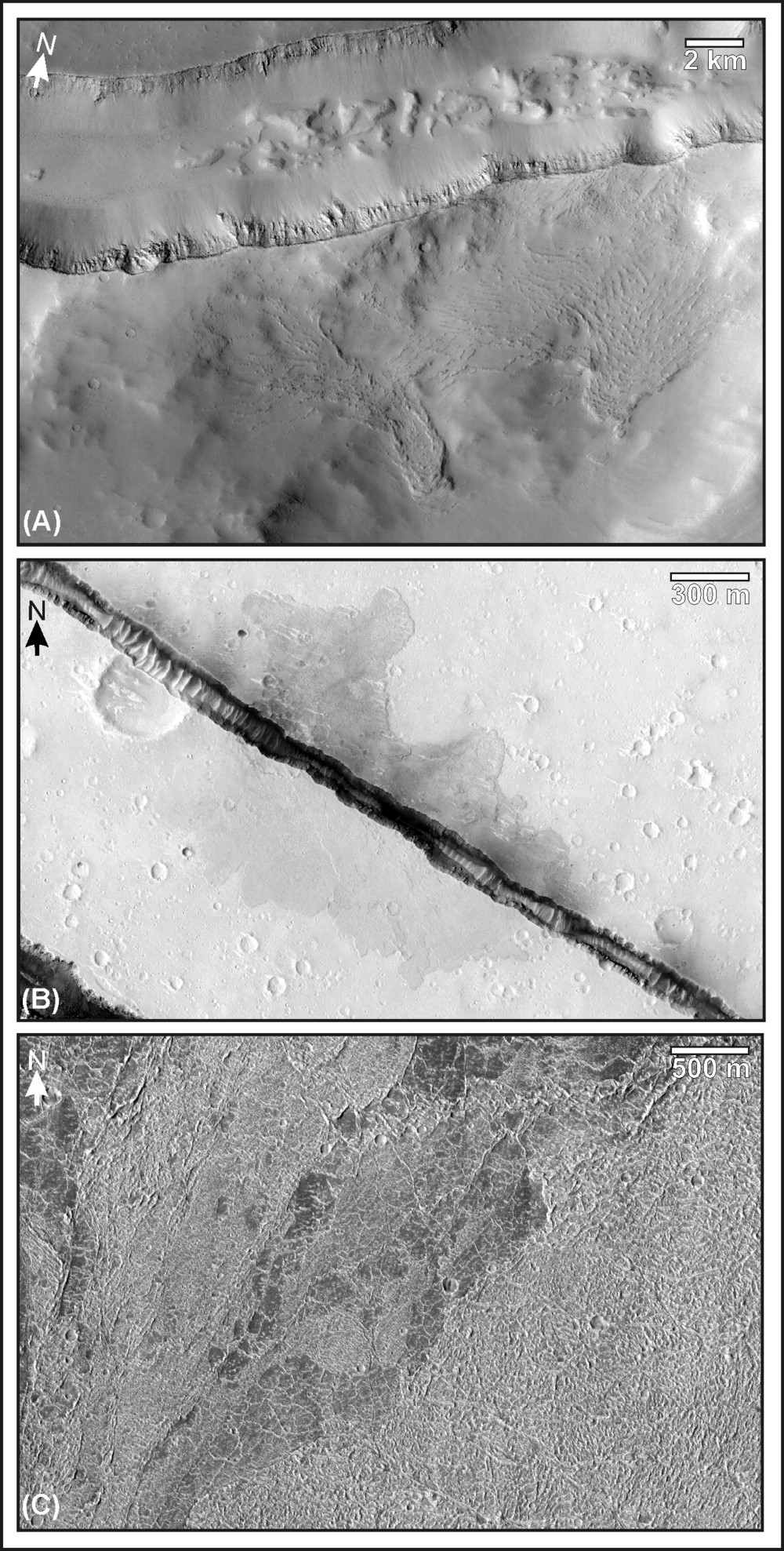
Figure 25: Many Martian outflow channels head at source features that clearly mark the sites of voluminous effusion of lava from the subsurface. (A) Ridged flows that extend downslope from the head graben of Mangala Valles; these flows are found on both the north and south sides of the graben and are counterparts to those erupted from the same structure at nearby Daedalia Planum [Leverington, 2007]. (B) Lobate-margined flows erupted from one of the numerous extensional features that mark the head region of Athabasca Valles, a system that appears to be completely mantled by volcanic flows [Jaeger et al., 2007, 2010]. (C) Platy-ridged flows erupted at the head of the largest outflow channel, Kasei Valles [Chapman et al., 2010]. Other features commonly found at the heads of Martian outflow channels include mare-style ridged plains and disturbed terrains comparable to the heads of numerous lunar and Venusian systems. Image numbers: (A) Mars Reconnaissance Orbiter Context Camera (CTX) image P08_003991_1636_XN_16S148W; (B) HiRISE image PSP-7197-1910; (C) HiRISE image PSP-10225-1795. Figure centers: (A) 18.15 degrees S., 148.7 degrees W.; (B) 10.7 degrees N., 156.4 degrees E.; (C) 0.4 degrees S., 80.4 degrees W.
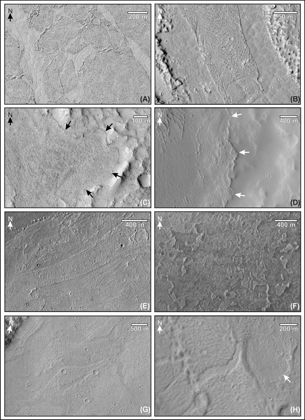
Figure 26: Though a notable diversity of volcanic landforms and deposits is visible at young and well-exposed systems such as Athabasca Valles [e.g., Keszthelyi et al., 2000, 2004, 2006; Jaeger et al., 2007, 2010], features with clear volcanic affinities are present along most outflow systems [Leverington, 2011]. (A) Platy-ridged flows at which plates are separated by materials with polygonal lava-lake textures, Athabasca Valles. (B) Ridged flows separated by shear zones from adjacent units with polygonal lava-lake textures, Athabasca Valles. (C) Overflow unit with lobate margins (flow front marked by arrows), Athabasca Valles. (D) Overflow unit with lobate margins and ridged character (flow front marked by arrows), Kasei Valles. (E) Ridged flow separated by shear zones from adjacent flow materials, Kasei Valles. (F) Inflated lava flows, Kasei Valles. (G) Platy-ridged flows, Labou Vallis branch of Mangala Valles. (H) Thinly mantled flows with platy-ridged character and polygonal texture (arrow), Mangala Valles. Additional examples of features such as these include the roofed subchannels and inflated flows of Mangala Valles [Leverington, 2007]; the lobate-margined overflows and slabby flows of Allegheny Vallis and Elaver Vallis [Leverington, 2009]; and the wrinkle-ridged units that are discontinuously present along the floors of almost all outflow systems. Image numbers: (A) HiRISE TRA_000854_1855; (B) HiRISE PSP_001540_1890; (C) HiRISE PSP_006472_1855; (D) HiRISE PSP_010607_2040; (E) HiRISE PSP_007825_2010; (F) HiRISE PSP_010000_2055; (G) CTX P13_006180_1717_XN_08S153W; (H) HiRISE PSP_007617_1750.
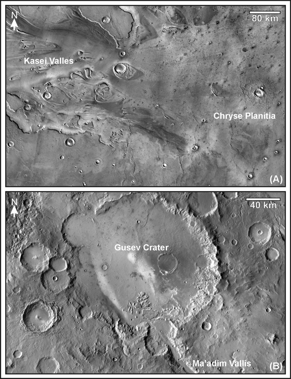
Figure 27: Along their lower reaches, the Martian outflow channels fade into plains with characteristics consistent with volcanic origins. (A) Kasei Valles and several other large outflow systems of the circum-Chryse region all terminate at the ridged volcanic plains of Chryse Planitia [e.g., Carr et al., 1976; Greeley et al., 1977; Arvidson et al., 1989]. (B) The smaller Ma’adim Vallis system similarly terminates at the ridged volcanic plains of Gusev Crater [e.g., Greeley et al., 2005]. This relation between outflow systems and volcanic plains on Mars is similar to that recognized on the Moon (see above). Thermal Emission Imaging System (THEMIS) daytime infrared mosaics courtesy of Arizona State University. Figure centers: (A) 25.5 degrees N., 49 degrees W.; (B) 14.6 degrees S., 175.5 degrees E.
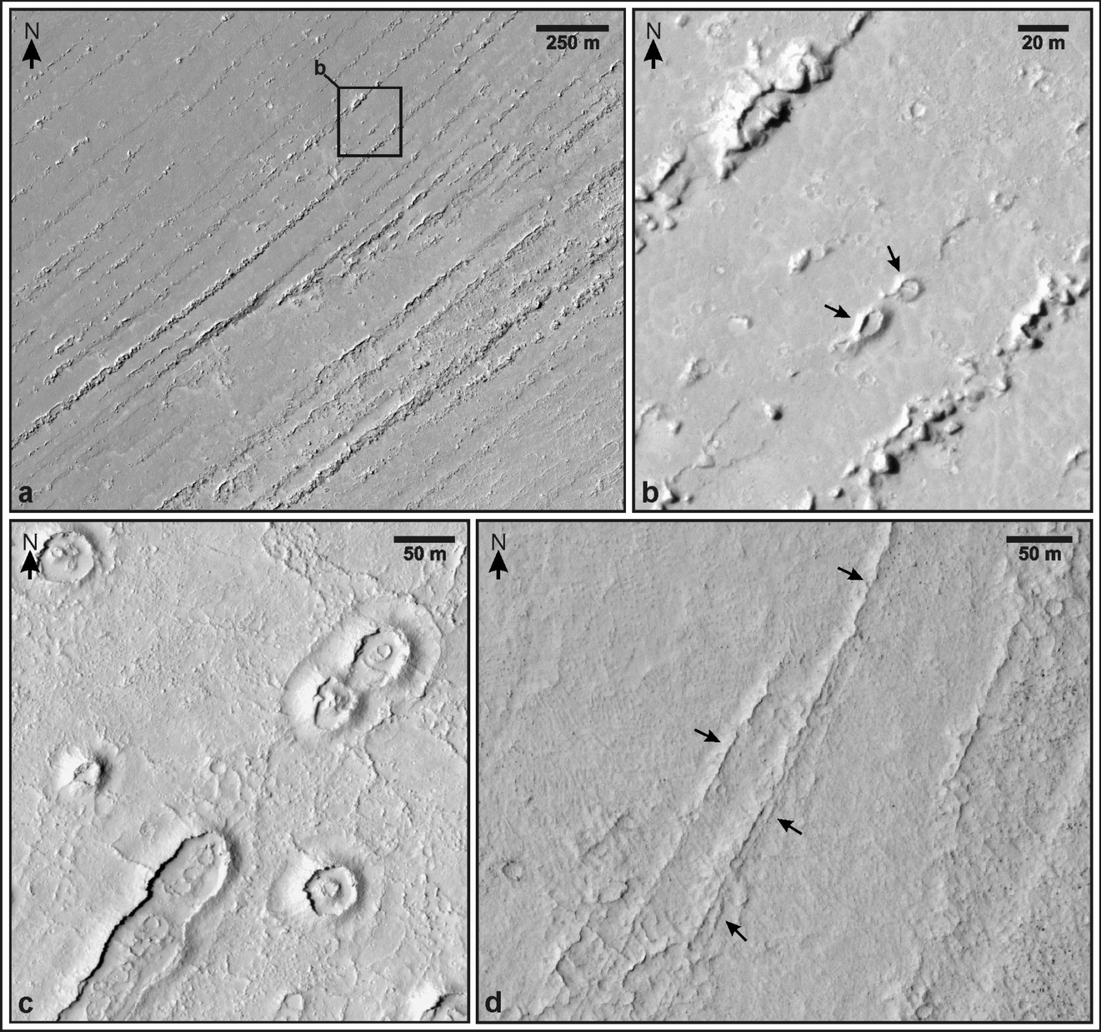
Figure 28: Large systems of longitudinal features developed in lava flows at Martian outflow channel Athabasca Valles (a) are partly composed of both equant and elongate classes of cone-like features (b and c), each mound partly defined by upturned layers [figure from Leverington, 2009]. Longitudinal ridge systems of the Cerberus plains are also partly formed by lineate exposures of upturned layer edges, as at Lethe Vallis (d). All of these landforms appear to be primary volcanic features developed during emplacement of associated flows [Jaeger et al., 2007, 2008], suggesting a capacity for development of longitudinally-oriented features by large channelized lava flows. HiRISE image PSP_008344_1895 (a and b), HiRISE image PSP_002226_1900 (c), HiRISE image PSP_006762_1840 (d). Approximate figure centers: a, 156 degrees 07’ E, 9 degrees 30’ N; b, 156 degrees 09’ E, 9 degrees 36’ N; c, 156 degrees 26’ 30” E, 9 degrees 39’ N; d, 155 degrees 26’ 30” E, 3 degrees 43’ N [Leverington, 2009].
As discussed above, the landing sites of the Viking 1 [e.g., Binder et al., 1977; Greeley et al., 1977], Pathfinder [e.g., McSween et al., 1999; Chapman and Kargel, 1999], and Spirit [e.g., McSween et al., 2004] spacecraft, all of which are located near the mouths of prominent Martian outflow channels, are plains with properties that are entirely consistent with volcanic origins [Leverington, 2004a, 2011]. In a manner similar to that of lunar volcanic plains visited by the Luna, Surveyor, and Apollo landers [e.g., Shoemaker et al., 1966, 1968, 1970; Schmitt and Cernan, 1973; Vaniman et al., 1991; Horz et al., 1991], surface materials at the three Martian landing sites appear to consist primarily of the remnants of volcanic units subjected to extensive reworking by impacts. As on the Moon, formation of a surface regolith layer at these sites has resulted in the reduction of original volcanic units to block fields consisting of rock fragments and fines.
5.1 Could Martian Igneous Intrusions Have Supplied Channel-Forming Eruptions?
Past development of large igneous intrusions within rocky bodies of the inner solar system is expected to have been driven by energy derived from early processes of accretion, gradual internal differentiation and cooling, and radioactive decay [e,g., Siegfried and Solomon, 1974; Horedt, 1980; Turcotte, 1980]. Large mantle-sourced bodies can buoyantly rise as a result of the density differences that exist between these bodies and surrounding materials. Rising bodies that are not confined by rheological or other mantle barriers will typically become stranded in neutral buoyancy zones (e.g., at the base of a planetary crust), where overlying materials are of lower bulk density [e.g., Head and Wilson, 1992; Ryan, 1994; Grosfils and Head, 1995; Wilson and Head, 2002]. Magmas stranded in neutral buoyancy zones can rise beyond these zones as a result of the lithostatic pressure P exerted by overlying materials:
(1) P = p g h
where p is the average density of the overlying materials, g is acceleration due to gravity (3.72 m/s2 for Mars), and h is depth below the surface [e.g., Turcotte and Schubert, 2002]. The igneous intrusions that develop above a magma chamber as a result of lithostatic pressure will generally be oriented approximately perpendicular to the least compressive stress within the host rock [e.g., Anderson, 1936; Rubin, 1995], ultimately forming intrusions such as dikes. The level to which magmas can be lithostatically driven is in large part constrained by the depth of the parent magma chamber. Equating the lithostatic pressure on the magma chamber with the hydrostatic pressure at the base of a growing intrusion, the maximum height above a stranded magma chamber that fluids can reach as a result of lithostatic pressure is given by:
(2) H = (Dhph) / pl
where H is the height above the stalled position, Dh is the thickness of the material above the magma chamber, ph is the average density of the material above the magma chamber, and pl is the density of the magma [Head and Wilson, 1992]. Though lithostatic pressure is a major control on the level to which magma can flow, magma will only rise beyond a stalled chamber if a path already exists and can be opened by magma pressure or if fluid pressures are sufficient to open a new path by overcoming the tensional strength of overlying rock [e.g., Rubin and Pollard, 1987; Rubin, 1995]. In the absence of excess pressures such as those related to dynamic inflow into a magma chamber [e.g., Chen et al., 2007] or to favorable gradients of tectonic stress [e.g., Rubin, 1995], magma intrusions will generally reach no shallower than the level given by Eq. (2).
Assuming existing paths to the surface can be exploited or new paths can be developed, a deeper chamber will tend to have a greater capacity to send magma to the surface than a shallower chamber. The deepest magma chambers should include those that become stranded beneath thick crusts and those that become confined by deep traps associated with rheological boundaries in mantle materials [e.g., Head and Wilson, 1992]. For magma chambers that become stalled among mantle materials, the maximum height to which magma can rise in a connected path is modified from Eq. (2):
(3) Hpl= Dcpc + Dmpm
where H is the height above the stalled position, pl is the density of the magma, Dc is the thickness of the crust above the magma chamber, Dm is the thickness of mantle materials above the magma chamber, pc is the average density of the overlying crust, and pm is the average density of overlying mantle materials [Head and Wilson, 1992].
Can Martian igneous intrusions have supplied magma to the surface at volumes and rates sufficient for channel development? Assuming a typical highland crustal thickness of 75 km [e.g., Andrews-Hanna et al., 2008], a large magma chamber stranded at the base of the crust will be subjected to a lithostatic pressure of ~810 MPa. If the average density of crustal materials is 2900 kg/m3 and if the density of basaltic magmas is assumed to be 3000 kg/ m3, Eq. (2) implies that a dike could rise no closer to the Martian surface than a depth of ~2500 m, allowing eruption only along the floors of isolated and deep topographic basins. However, assuming a mantle density of 3500 kg/m3, a magma chamber stranded at a rheological transition marking the base of a 120- to 200-km-thick lithosphere [e.g., Andrews-Hanna et al., 2008] would be subjected to a lithostatic pressure of ~1.4 to 2.4 GPa. This pressure would be theoretically sufficient to raise a magma column ~5 to 18 km above the Martian surface, if the imaginary chamber were of a volume sufficient to allow formation of an intrusion to the surface and to allow additional magma to be expelled to the Martian surface. For realistic igneous systems, the available magma volume would be a key limiting factor on the volume ultimately expelled to the surface. In the consideration of the capacity of Martian intrusions for driving large channel-forming eruptions, it can be useful to examine past estimates of the volumes of large Martian intrusions. For example, the large individual dikes that are believed to underlie the Tharsis-radial graben system are predicted to have mean widths up to ~400 m and typical lengths of up to ~ 3000 km [Wilson and Head, 2002]. Assuming the height of a giant Martian dike to be 120 km [Wilson and Head, 2002], a single intrusion with a width of 200 m and length of 2000 km would have a volume of ~ 48,000 km3. If only an additional ~17% of this volume were to be erupted to the surface, it would correspond to the ~8000 km3 magma volume estimated by Jaeger et al. [2010] to have been involved in mechanical erosion of the Athabasca Valles outflow system. Still larger erupted volumes, such as the ~2 x 10⁵ km3 estimated to have been involved in volcanic development of the Mangala Valles system [Leverington, 2007], might similarly be realistic consequences of eruption from one or more large intrusions extending from reservoirs stranded within the upper mantle. Though the above calculations are crude estimates that ignore all but the most basic considerations, they suggest that igneous processes should indeed be viable mechanisms by which the outflow channels of Mars could have developed. The very existence of large volcanic outflow systems on the Moon, Mercury, and Venus is consistent with this perspective.
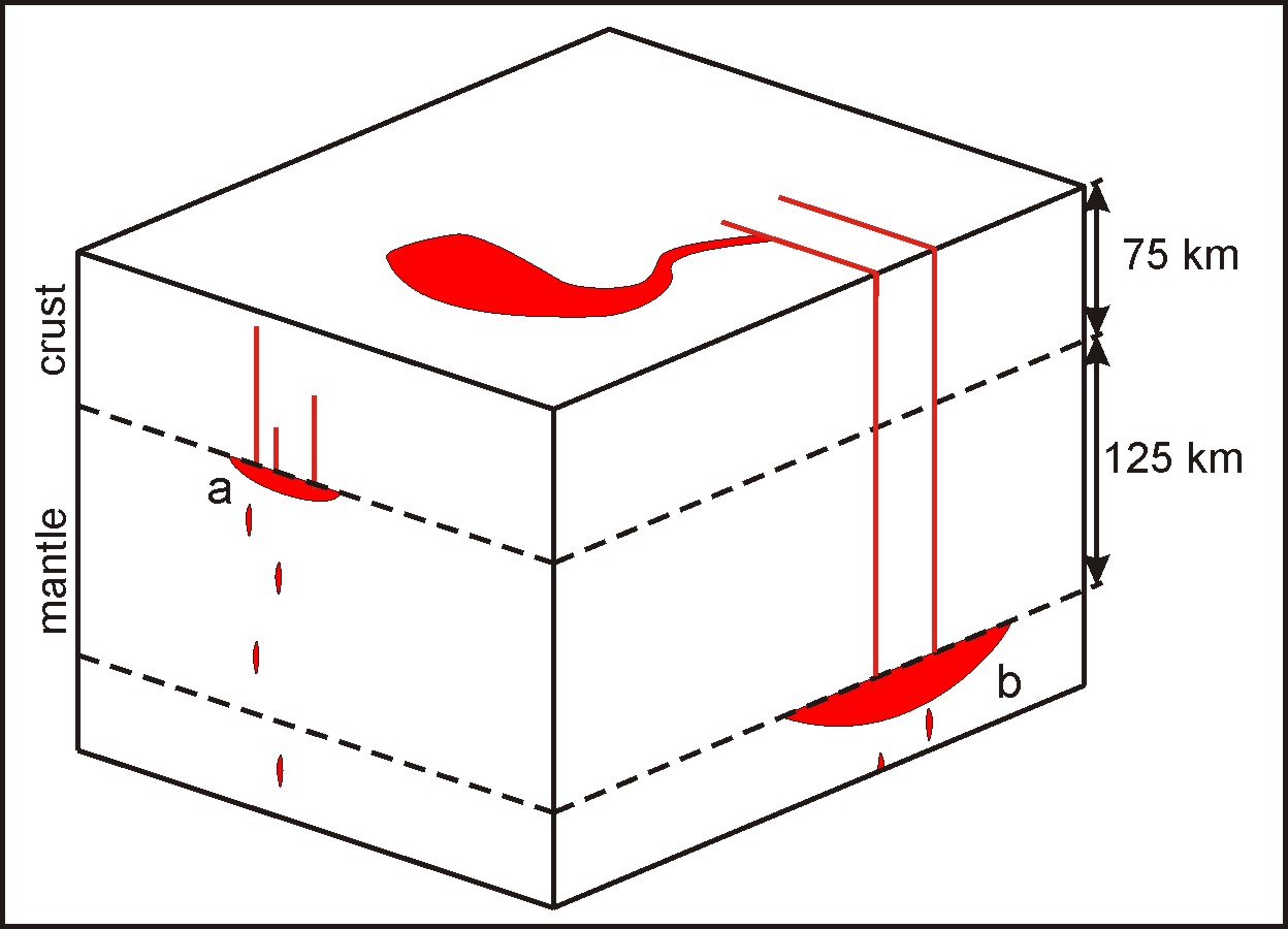
Figure 29: The lithostatic pressure on a magma chamber stranded beneath a 75-km-thick Martian crust (a) will generally be of insufficient magnitude (810 MPa) to allow intrusions to reach the surface, except at local topographic lows such as impact craters and tectonic features. In comparison, a magma chamber stranded at a rheological boundary such as that at the base of a 120- to 200-km-thick lithosphere will be characterized by sufficient pressure (~1.4 to 2.4 GPa) to drive rapid and voluminous eruptions to the surface; the 200 km scenario is depicted at b. The volumes of large individual dikes on Mars should reach or exceed ~50,000 km3[e.g., Wilson and Head, 2002], suggesting that relatively rapid eruption of comparable volumes to the Martian surface might have been possible if intrusions such as these were fed by and connected to large reservoirs stranded at similarly shallow depths of the mantle [Leverington, 2011].
5.2 Broader Implications of Volcanic Origins for the Outflow Channels of Mars
Hypotheses for aqueous development of the outflow channels of Mars do not appear to be viable, on the basis of associated requirements for implausible properties of the Martian near-surface, for water abundances that are orders of magnitude greater than can be independently justified, for long-term near-surface conditions that may not be congruous with the preserved mineralogical record, for prominent aqueous deposits that have not yet been confidently identified along channels and at terminal basins, and for the action of processes for which there are no known solar system analogs [Leverington, 2004a, 2011]. Instead, the volcanic hypothesis for development of the outflow channels of Mars appears to represent the simplest and most effective means by which these systems can be understood. This hypothesis is founded upon the existence of volcanic analog landforms on multiple bodies of the inner solar system and on corresponding analog processes that are high volume and low viscosity variations on familiar terrestrial volcanic themes. The volcanic hypothesis is compatible with available mineralogical data for Mars, is consistent with the nature of landforms and deposits found along the lengths of Martian channels, and brings the outflow channels into conformity with the low near-surface water abundances predicted by geochemical considerations. The volcanic hypothesis is also consistent with recent volcanic interpretations of smaller Martian channels that possess characteristics similar to those of larger systems, such as streamlined erosional residuals and complex sinuous or anastamosing reaches [Leverington and Maxwell, 2004; Williams et al., 2005; Leverington, 2006; Caprarelli et al., 2007; Garry et al., 2007; Keszthelyi et al., 2008; Rampey and Harvey, 2008; Hauber et al., 2009; Bleacher et al., 2010].
More fundamentally, the volcanic hypothesis is attractive as it fits within a wider geological framework that realistically and economically accounts for the existence and nature of outflow systems located on several bodies of the inner solar system. The outflow systems of Mars are presently treated as features distinct from volcanic channels of the Earth, Moon, Mercury, and Venus, but the volcanic hypothesis suggests that these systems are products of the same processes and are, at their most basic level, variations within the same family of landform. A volcanic origin for the outflow channels of Mars would further highlight the capacity of ancient lava flows for voluminous effusion and significant erosion by thermal or mechanical processes and would imply an important new unification in major effusive volcanic processes and landforms across at least three bodies of the inner solar system. A volcanic origin for the Martian outflow channels would imply that outflow zones are the surface expressions of magmatic systems rather than the locations of past aqueous outbursts from aquifers. As such, the outflow channels would join the large Martian shields as among the most prominent volcanic landforms in the solar system. The northern lowlands of Mars are characterized by vast volcanic plains of Hesperian age [Head et al., 2002] that mantle densely cratered units of Noachian age [Frey et al., 2002], and a volcanic origin for the Martian outflow channels would imply that these plains are, as with the lunar maria, partly composed of volcanic units sourced from outflow channels.
If the outflow systems of Mars, Venus, Mercury, and the Moon developed through common volcanic processes, might large analogous systems have developed on the Earth during the Hadean or Archean eras? Even today, terrestrial outflow processes can form the modest channel systems commonly involved in constructive emplacement of volcanic flows on the Earth [e.g., Greeley, 1971ab, 1977; Greeley and Hyde, 1972; Peterson and Swanson, 1974]. Unfortunately, the poor preservation of early terrestrial crust [Kamber et al., 2005], combined with variations in the inner solar system with regard to volatile abundance, crustal thickness, degree of differentiation, thermal history, and activity of plate tectonics [Anderson, 1984; O’Neill et al., 2007], presently limits inferences of the past existence of large terrestrial outflow systems to the realm of speculation. Although early mantle temperatures were high [Ryder et al., 2000] and mantle processes likely had the capacity to drive periodic resurfacing events [Davies, 2008], formation of outflow systems on Earth could have been inhibited by the existence of voluminous near-surface water reservoirs [e.g., Ryder et al., 2000], the operation of early plate tectonic processes [e.g., Hopkins et al., 2008], or limiting aspects of early mantle chemistry [e.g., Carr and Wänke, 1992].
If the volcanic hypothesis for outflow channel development on Mars is correct, potential implications extend beyond those directly related to the origins of solar system channels. The volcanic hypothesis does not rely upon ancient swings in Martian climatic conditions or atmospheric properties and is therefore consistent with a wide range of possible climatic histories, including the long-term cold and dry conditions implied by global surface mineralogy [e.g., Hoefen et al., 2003; Bibring et al., 2006; Forget, 2007; Koeppen and Hamilton, 2008]. Since inferences of the existence of large northern lakes and oceans during the Hesperian and Amazonian are based mainly on aqueous interpretations of outflow systems [e.g., Parker et al., 1989; Scott et al., 1992; De Hon and Pani, 1993; Wharton et al., 1995; Komatsu and Ori, 2000; Williams et al., 2000; Baker, 2001, 2009c; Head et al., 2001; Jakosky and Phillips, 2001; Masson et al., 2001; Parker and Currey, 2001; Carr and Head, 2003; Fairén et al., 2003], a volcanic origin for the outflow channels would substantially change our understanding of the nature and extent of past aqueous environments on Mars.
Development of life on Mars would have likely required environments within which liquid water was stable over some amount of time [e.g., McKay and Stoker, 1989; McKay et al., 1992; Chyba and McDonald, 1995; Mancinelli and Banin, 1995; Wharton et al., 1995; Brack and Pillinger, 1998; Hiscox, 2001]. Among the ancient Martian environments identified as potentially supportive of past biological activity are the outflow channels themselves [e.g., Burr et al., 2002a; Dohm et al., 2004; Levy and Head, 2005; Murray et al., 2005; Warner et al., 2010], oceans at the mouths of outflow systems [e.g., Helfer, 1990; Wharton et al., 1995; Komatsu and Ori, 2000; Parker and Currey, 2001], water bodies and zones of hydrothermal activity at channel heads [e.g., Rodriguez et al., 2005; Coleman et al., 2007; Schulze-Makuch et al., 2007], and a range of other associated surface or subsurface environments [e.g., McKay, 1997; Dohm et al., 2004; Schulze-Makuch et al., 2005]. A volcanic origin for the Martian outflow channels would dramatically narrow the possible range of environments once supportive of Hesperian or Amazonian life and could reduce the broader likelihood of past life on Mars by diminishing the geomorphological justification for the existence of immense but hidden near-surface water reservoirs. Because many of the regions of greatest interest on Mars correspond to those most likely to have experienced the prolonged activity of liquid water [e.g., Farmer et al., 1995; Hubbard et al., 2002; Jakosky and Mellon, 2004], recognition of a volcanic origin for the Martian outflow channels could decrease the appeal of outflow sites previously considered to be prime targets for future robotic or human exploration. Despite narrowing the possible range of Martian environments once hospitable to life, recognition of a volcanic origin for the outflow channels of Mars could improve our capacity for discrimination of sites of genuine astrobiological significance by highlighting the greater importance of other Martian sites characterized by clearer records of past aqueous conditions.
Volcanic interpretations of the Martian outflow channels raise important new questions regarding the fundamental nature of all channel systems on Mars. If Martian volcanic processes had the capacity in the Hesperian and Amazonian epochs for generation of outflow systems with characteristics that superficially resemble those of aqueous systems, might other Martian channel systems share common volcanic origins? The properties of highland channel networks of Hesperian age are considered by some workers to be consistent with formation through regional volcanic resurfacing [e.g., Leverington and Maxwell, 2004; Leverington, 2006]. Might large low-order sinuous channel networks such as the Nanedi and Nirgal systems, by analogy with remarkably similar lunar and Venusian features, have been formed by low viscosity lava flows rather than conventionally cited aqueous sapping processes or surface overflow? Because volcanic channel origins do not require special atmospheric properties for development, recognition of the widespread predominance of volcanic processes in Hesperian and Amazonian channel formation could further influence our understanding of ancient climatic conditions and volatile stores.
A volcanic origin for the largest channels in the solar system raises questions regarding the basic nature of involved igneous processes. For example, what flow volumes and rates of effusion were involved in the formation of specific Martian systems, and what ranges of physical properties (temperatures of eruption, lava chemistries, lava yield strengths, Reynolds numbers) were once associated with these flows [e.g., Schonfeld, 1976, 1977a,b, 1979a,b; McGetchin and Smith, 1978; Wilson and Mouginis-Mark, 2001; Williams et al., 2005; Leverington, 2007, 2009; Jaeger et al., 2010]? How would the properties of Martian flows have compared with those of flows associated with lunar, Mercurian, and Venusian outflow systems? To what relative extents were thermal erosion (involving the melting of substrates by thermal energy) and mechanical erosion (involving the physical removal of substrates by kinetic energy) involved in channel incision [Cutts et al., 1978; Leverington, 2007; Hurwitz et al., 2010; Jaeger et al., 2010]? Though erosive processes seem likely to have dominated in the formation of major channel systems, what roles might constructive volcanic processes have also played in system development? Still more fundamental questions arise: what kinds of intrusive igneous bodies would have been necessary to supply inferred flow volumes at required rates of effusion [Jaeger et al., 2010]? On the Moon, eruption of large volumes of low viscosity lava should have been possible from deep intrusions associated with magma conduits only slightly wider than those common on the Earth [Wilson and Head, 1981, 2010; Head and Wilson, 1991, 1992]. Similarly deep and voluminous source magma chambers have been surmised for the outflow channels of Mars [McGetchin and Smith, 1978; Jaeger et al., 2010], but many uncertainties remain [Leverington, 2011].
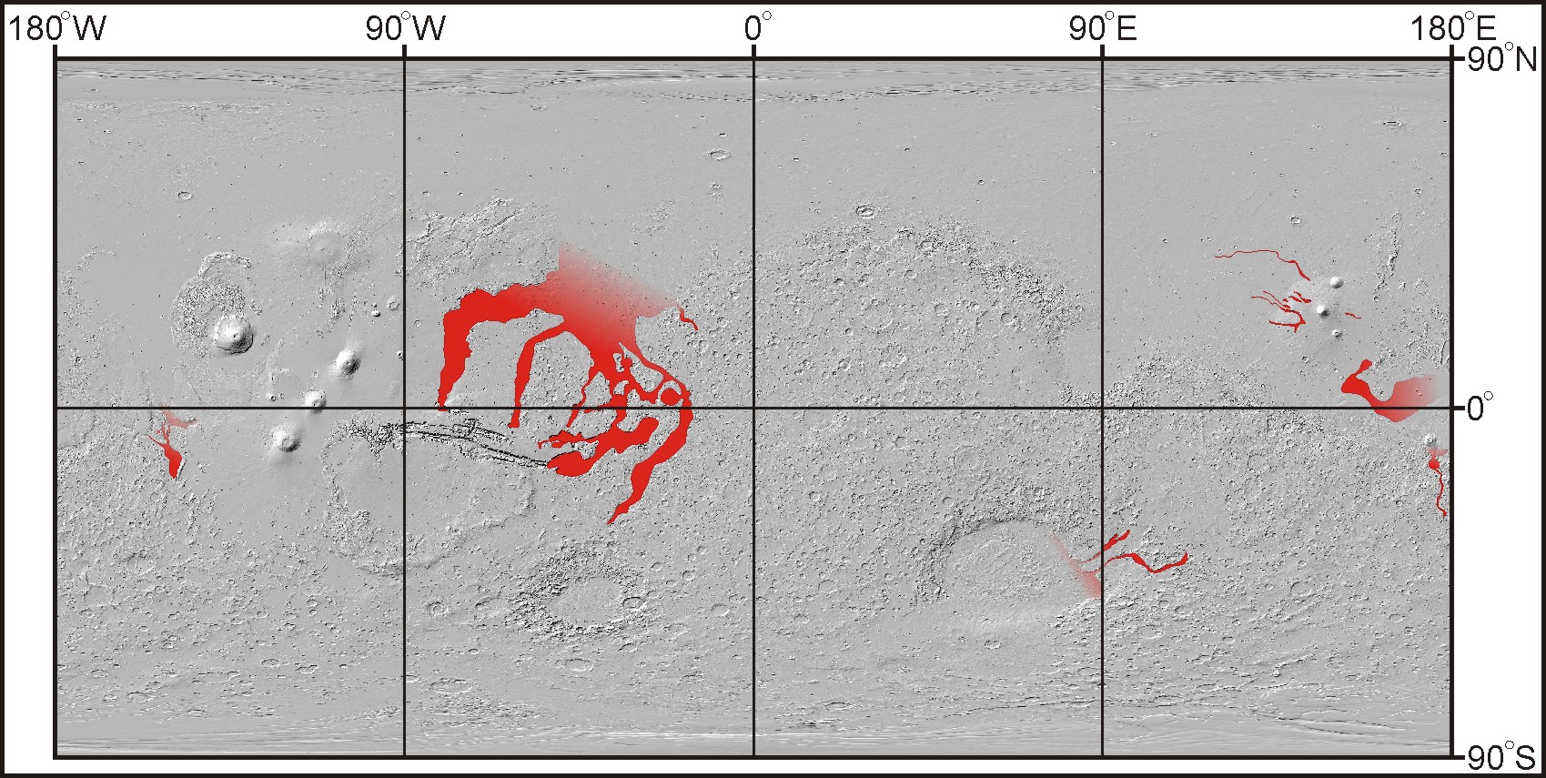
Figure 30: A volcanic origin for the largest outflow channels of Mars (red) would render these features among the most prominent igneous landforms in the solar system [Leverington, 2011]. A volcanic origin would also imply that, as at the lunar maria, the ridged volcanic plains at terminal basins are partly composed of flows derived from these outflow systems. Global map of shaded topography after Smith et al. [2003].

5 References Cited and Further Reading
Anders, E., Owen, T., 1977. Mars and Earth: origin and abundance of volatiles. Science 198, 453-465.
Anderson, D., 1984. The Earth as a planet: paradigms and paradoxes. Science 223, 347-355.
Anderson, R.C., Dohm, J.M., Golombek, M.P., Haldemann, A.F.C., Franklin, B.J., Tanaka, K.L., Lias, J., Peer, B., 2001. Significant centers of tectonic activity through time for the western hemisphere of Mars. J. Geophys. Res. 106, 20,563-20,585.
Andrews-Hanna, J.C., Phillips, R.J., 2007. Hydrological modeling of outflow channels and chaos regions on Mars. J. Geophys. Res. 112, E08001, doi:10.1029/2006JE002881.
Arvidson, R.E., Gooding, J.L., Moore, H.J., 1989. The Martian surface as imaged, sampled, and analyzed by the Viking landers. Rev. Geophys. 27, 39-60.
Arvidson, R.E., Squyres, S.W., Anderson, R.C., Bell III, J.F., Blaney, D., Brückner, J., Cabrol, N.A., Calvin, W.M., Carr, M.H., Christensen, P.R., Clark, B.C., Crumpler, L., Des Marais, D.J., de Souza Jr., P.A., d’Uston, C., Economou, T., Farmer, J., Farrand, W.H., Folkner, W., Golombek, M., Gorevan, S., Grant, J.A., Greeley, R., Grotzinger, J., Guinness, E., Hahn, B.C., Haskin, L., Herkenhoff, K.E., Hurowitz, J.A., Hviid, S., Johnson, J.R., Klingelhöfer, G., Knoll, A.H., Landis, G., Leff, C., Lemmon, M., Li, R., Madsen, M.B., Malin, M.C., McLennan, S.M., McSween, H.Y., Ming, D.W., Moersch, J., Morris, R.V., Parker, T., Rice Jr., J.W., Richter, L., Rieder, R., Rodionov, D.S., Schröder, C., Sims, M., Smith, M., Smith, P., Soderblom, L.A., Sullivan, R., Thompson, S.D., Tosca, N.J., Wang, A., Wänke, H., Ward, J., Wdowiak, T., Wolff, M., Yen, A., 2006. Overview of the Spirit Mars Exploration Rover mission to Gusev crater: landing site to Backstay Rock in the Columbia Hills. J. Geophys. Res. 111, E02S01, doi:10.1029/2005JE002499.
Asimow, P.D., Wood, J.A., 1992. Fluid outflows from Venus impact craters: analysis from Magellan data. J. Geophys. Res. 97, 13,643-13,665.
Baird, A.K., Clark, B.C., 1984. Did komatiitic lavas erode channels on Mars? Nature 311, 18-19.
Baker, V.R., 1978a. A preliminary assessment of the fluid erosional processes that shaped the martian outflow channels. Proc. Lunar Planet. Sci. Conf., 9th, Houston. Lunar and Planetary Institute, Houston, TX, pp. 3205-3223.
Baker, V.R., 1978b. Large-scale erosional and depositional features of the Channeled Scabland. In: Baker, V.R., Nummedal, D. (Eds.), The Channeled Scabland: A Guide to the Geomorphology of the Columbia Basin, Washington. NASA, Washington, DC, pp. 81-115.
Baker, V.R., 1978c. The Spokane flood controversy and the Martian outflow channels. Science 202, 1249-1256.
Baker, V.R., 1979. Erosional processes in channelized water flows on Mars. J. Geophys. Res. 84, 7985-7993.
Baker, V.R., 1982. The Channels of Mars. Univ. of Tex. Press, Austin, TX.
Baker, V.R., 2001. Water and the martian landscape. Nature 412, 228-236.
Baker, V.R., 2004. A brief geological history of water on Mars. In: Seckbach, J. (Ed.), Origins: Genesis, Evolution and Diversity of Life. Kluwer Academic Publishers, Norwell, MA, pp. 621-631.
Baker, V.R., 2006. Geomorphological evidence for water on Mars. Elements 2, 139-143.
Baker, V.R., 2009a. The Channeled Scabland: a retrospective. Annu. Rev. Earth Planet. Sci. 37, 393-411.
Baker, V.R., 2009b. Overview of megaflooding: Earth and Mars. In: Burr, D.M., Carling, P.A., Baker, V.R. (Eds.), Megaflooding on Earth and Mars. Cambridge Univ. Press, New York, pp. 1-12.
Baker, V.R., 2009c. Megafloods and global paleoenvironmental change on Mars and Earth, In: Burr, D.M., Carling, P.A., Baker, V.R. (Eds.), Megaflooding on Earth and Mars. Cambridge Univ. Press, New York, pp. 25-36.
Baker, V.R., Bunker, R.C., 1985. Cataclysmic Late Pleistocene flooding from glacial Lake Missoula: a review, Quat. Sci. Rev. 4, 1-41.
Baker, V. R., Kochel, R.C., 1978a. Morphometry of streamlined forms in terrestrial and martian channels. Proc. Lunar Planet Sci. Conf., 9th, 3193-3203.
Baker, V. R., Kochel, R.C., 1978b. Morphological mapping of martian outflow channels, Proc. Lunar Planet Sci. Conf., 9th, 3181-3192.
Baker, V.R., Kochel, R.C., 1979. Martian channel morphology: Maja and Kasei Valles. J. Geophys. Res. 84, 7961-7983.
Baker, V.R., Komatsu, G., 1999. Extraterrestrial fluvial forms, in Varieties of Fluvial Form. A.J. Miller and A. Gupta (Eds.), pp.11-30, John Wiley & Sons Ltd.
Baker, V.R., Milton, D.J., 1974. Erosion by catastrophic floods on Mars and Earth. Icarus 23, 27-41.
Baker, V.R., Benito, G., Rudoy, A.R., 1993. Paleohydrology of Late Pleistocene superflooding, Altay Mountains, Siberia. Science 259, 348-350.
Baker, V.R., Strom, R.G., Gulick, V.C., Kargel, J.S., Komatsu, G., Kale, V.S., 1991. Ancient oceans, ice sheets and the hydrological cycle on Mars. Nature 352, 589-594.
Baker, V.R., Carr, M.H., Gulick, V.C., Williams, C.R., Marley, M.S., 1992a. Channels and valley networks. In: Kieffer, H.H., Jakosky, B.M., Snyder, C.W., Matthews, M.S. (Eds.), Mars. Univ. of Ariz. Press, Tucson, AZ, pp. 493-522.
Baker, V.R., Komatsu, G., Parker, T.J., Gulick, V.C., Kargel, J.S., Lewis, J.S., 1992b. Channels and valleys on Venus: preliminary analysis of Magellan data. J. Geophys. Res. 97, 13,421-13,444.
Baker, V.R., Komatsu, G., Gulick, V.C., Parker, T.J., 1997. Channels and valleys. In: Bougher, S.W., Hunten, D.M., Phillips, R.J. (Eds.), Venus II. Univ. of Ariz. Press, Tucson, AZ, pp. 757-793.
Barlow, N.G., Bradley, T.L., 1990. Martian impact craters: correlations of ejecta and interior morphologies with diameter, latitude, and terrain. Icarus 87, 156-179.
Basilevsky, A.T., Neukum, G., Werner, S.C., Dumke, A., van Gasselt, S., Kneissl, T., Zuschneid, W., Rommel, D., Wendt, L., Chapman, M., Head, J.W., Greeley, R., 2009. Episodes of floods in Mangala Valles, Mars, from the analysis of HRSC, MOC and THEMIS images. Planet. Space Sci. 57, 917-943.
Beaty, D.W., Clifford, S.M., Borg, L.E., Catling, D.C., Craddock, R.A., Des Marais, R.J., Farmer, J.D., Frey, H.V., Haberle, R.M., McKay, C.P., Newsom, H.E., Parker, T.J., Segura, T., Tanaka, K.L., 2005. Key science questions from the Second Conference on Early Mars: geologic, hydrologic, and climatic evolution and the implications for life. Astrobiology 5, 663-689.
Benito, G., O’Connor, J.E., 2003. Number and size of last-glacial Missoula floods in the Columbia River valley between the Pasco Basin, Washington, and Portland, Oregon. Bull. Geol. Soc. Am. 115, 624-638.
Bibring, J.-P., Langevin, Y., Gendrin,, A., Gondet, B., Poulet, F., Berthé, M., Soufflot, A., Arvidson, R., Mangold, N., Mustard, J., Drossart, P., OMEGA Team, 2005. Mars surface diversity as revealed by the OMEGA/Mars Express Observations. Science 307, 1576-1581.
Bibring, J.-P., Langevin, Y., Mustard, J.F., Poulet, F., Arvidson, R., Gendrin, A., Gondet, B., Mangold, N., Pinet, P., Forget, F., OMEGA Team, 2006. Global mineralogical and aqueous mars history derived from OMEGA/Mars Express data. Science 312, 400-404.
Binder, A.B., R.E. Arvidson, E.A. Guinness, K.L. Jones, E.C. Morris, T.A. Mutch, D.C. Pieri, C. Sagan, 1977. The geology of the Viking Lander 1 site. J. Geophys. Res., 82, 4439-4451.
Blasius, K.R., Cutts, J.A., Roberts, W.J., 1978. Large scale erosive flows associated with Chryse Planitia, Mars: source and sink relationships. Lunar Planet. Sci. Conf., 9th, Houston. Lunar and Planetary Institute, Houston, TX, (abstract, pp. 109-110).
Bleacher, J.E., de Wet, A.P., Garry, W.B., Zimbelman, J.R., Trumble, M.E., 2010. Volcanic or fluvial: comparison of an Ascraeus Mons, Mars, braided and sinuous channel with features of the 1859 Mauna Loa flow and Mare Imbrium flows. Lunar Planet. Sci. Conf., 41st, Houston. Lunar and Planetary Institute, Houston, TX, (abstract 1612).
Boynton, W.V., Feldman, W.C., Squyres, S.W., Prettyman, T.H., Brückner, J., Evans, L.G., Reedy, R.C., Starr, R., Arnold, J.R., Drake, D.M., Englert, P.A.J., Metzger, A.E., Mitrofanov, I., Trombka, J.I., d’Uston, C., Wänke, H., Gasnault, O., Hamara, D.K., Janes, D.M., Marcialis, R.L., Maurice, S., Mikheeva, I., Taylor, G.J., Tokar, R., Shinohara, C., 2002. Distribution of hydrogen in the near surface of Mars: evidence for subsurface ice deposits. Science 297, 81-85.
Brack, A., Pillinger, C.T., 1998. Life on Mars: chemical arguments and clues from Martian meteorites. Extremophiles 2 313-319.
Bretz, J.H., 1923. The channeled scablands of the Columbia Plateau. Geology 31, 617-649.
Bretz, J.H., Smith, H.T.U., Neff, G.E., 1956. Channeled scabland of Washington: new data and interpretations. Bull. Geol. Soc. Am. 67, 957-1049.
Bridges, J.C., Catling, D.C., Saxton, J.M., Swindle, T.D., Lyon, I.C., Grady, M.M., 2001. Alteration assemblages in Martian meteorites: implications for near-surface processes. Space Sci. Rev. 96, 365-392.
Bryson, K. L., Chevrier, V., Sears, D.W.G., Ulrich, R., 2008. Stability of ice on Mars and the water vapor diurnal cycle: experimental study of the sublimation of ice through a fine-grained basaltic regolith. Icarus 196, 446-458.
Bunch, T.E., Reid, A.M., 1975. The Nakhlites part I: petrography and mineral chemistry. Meteoritics 10, 303-324.
Burr, D.M., 2003. Hydraulic modelling of Athabasca Vallis, Mars. Hydrol. Sci. J. 48, doi:10.1623/hysj.48.4.655.51407, 655-664.
Burr, D.M., 2005. Clustered streamlined forms in Athabasca Valles, Mars: evidence for sediment deposition during floodwater ponding. Geomorphology 69, 242-252.
Burr, D., 2010. Palaeoflood-generating mechanisms on Earth, Mars, and Titan. Global and Planetary Change 70, doi: 10.1016/j.gloplacha.2009.11.003.
Burr, D.M., Parker, A.H., 2006. Gjotá Valles and implications for flood sediment deposition on Mars. Geophys. Res. Lett. 33, L22201, doi:10.1029/2006GL028011.
Burr, D.M., McEwen, A.S., Sakimoto, S.E.H., 2002a. Recent aqueous floods from the Cerberus Fossae, Mars. Geophys. Res., Lett. 29, 10.1029/2001GL013345.
Burr, D.M., Grier, J.A., McEwen, A.S., Keszthelyi, L.P., 2002b. Repeated aqueous flooding from the Cerberus Fossae: evidence for very recently extant, deep groundwater on Mars. Icarus 159, 53-73.
Bussey, D.B.J., Sřrensen, S.-A., Guest, J.E., 1995. Factors influencing the capability of lava to erode its substrate: application to Venus. J. Geophys. Res. 100(E8), 16,941-16,948.
Byrne, P.K., Klimczak, C., Williams, D.A., Hurwitz, D.M., Solomon, S.C., Head, J.W., Preusker, F., Oberst, J., 2013. An assemblage of lava flow features on Mercury. J. Geophys. Res., 118, 1303-1322.
Calvari, S., Neri, M., Pinkerton, H., 2002. Effusion rate estimates during the 1999 summit eruption on Mount Etna, and growth of two distinct lava flow fields. J. Volcanol. Geotherm. Res. 119, 107-123.
Campbell, B.A., Carter, L.M., Hawke, B.R., Campbell, D.B., Ghent, R.R., 2008. Volcanic and impact deposits of the Moon’s Aristarchus Plateau: a new view from Earth-based radar images. Geology 36, 135-138, doi:10.1130/G24310A.1.
Caprarelli, G., Leitsch, E.C., 2009. Volcanic and structural history of the rocks exposed at Pickering Crater (Daedalia Planum, Mars). Icarus 202, 453-461.
Caprarelli, G., Pondrelli, M., Di Lorenzo, S., Marinangeli, L., Ori, G.G., Neukum, G., 2007. Mars Express High Resolution Stereo Camera: results of observations of north Tyrrhena Terra, Mars. In: Short, W. (Ed.), Proc. Austral. Space Sci. Conf., vol. 6, pp. 27-42.
Carling, P.A., Burr, D.M., Johnsen, T.F., Brennand, T.A., 2009. A review of open-channel megaflood depositional landforms on Earth and Mars. In: Burr, D.M., Carling, P.A., Baker, V.R. (Eds.), Megaflooding on Earth and Mars. Cambridge Univ. Press, Cambridge, pp. 33-49.
Carr, M.H., 1973. A generalized geologic map of Mars. J. Geophys. Res. 78, 4031-4036.
Carr, M.H., 1974. The role of lava erosion in the formation of lunar rilles and Martian channels. Icarus 22, 1-23.
Carr, M.H., Masursky, H., Baum, W.A., Blasius, K.R., Briggs, G.A., Cutts, J.A., Duxbury, T., Greeley, R., Guest, J.E., Smith, B.A., Soderblom, L.A., Veverka, J., Wellman, J.B., 1976. Preliminary results from the Viking orbiter imaging experiment. Science 193, 766-776.
Carr, M. H., R. Greeley, K. R. Blasius, J. E. Guest, J.B. Murray, 1977. Some Martian volcanic features as viewed from the Viking Orbiters. J. Geophys. Res. 82, 3985-4015.
Carr, M.H., 1979. Formation of Martian flood features by release of water from confined aquifers. J. Geophys. Res. 84, 2995-3007.
Carr, M.H., 1981. The Surface of Mars. Yale University Press, New Haven, Conn.
Carr, M.H., 1983. The stability of streams and lakes on Mars. Icarus 56, 476-495.
Carr, M.H., 1986. Mars: a water-rich planet? Icarus 68, 187-216.
Carr, M.H., 1987. Water on Mars. Nature 326, 30-35.
Carr, M.H., 1995. The martian drainage system and the origin of valley networks and fretted channels. J. Geophys. Res. 100, 7479-7507.
Carr, M.H., 1996. Water on Mars. Oxford Univ. Press, New York.
Carr, M.H., 2000. Martian oceans, valleys and climate. Astr. Geophys. 41, 3.20-3.26.
Carr, M.H., 2002. Elevations of water-worn features on Mars: implications for circulation of groundwater. J. Geophys. Res. 107, 5131, doi:10.1029/2002JE001845.
Carr, M.H., 2007. The Surface of Mars. Cambridge Univ. Press, Cambridge, England.
Carr, M.H., Head III, J.W., 2003. Oceans on Mars: an assessment of the observational evidence and possible fate. J. Geophys. Res. 108, 5042, doi:10.1029/2002JE001963.
Carr, M.H., Wänke, H., 1992. Earth and Mars: water inventories as clues to accretional histories. Icarus 98, 61-71.
Chadwick, D.J., G.G. Schaber, 1993. Impact crater outflows on Venus: Morphology and emplacement mechanisms. J. Geophys. Res. 98, 20,891-20,902.
Chapman, M.G., Kargel, J.S., 1999. Observations at the Mars Pathfinder site: do they provide ‘unequivocal’ evidence for catastrophic flooding? J. Geophys. Res. 104, 8671-8678.
Chapman, M.G., Tanaka, K.L., 2002. Related magma-ice interactions: possible origins of chasmata, chaos, and surface materials in Xanthe, Margaritifer, and Meridiani Terrae, Mars. Icarus 155, 324-339.
Chapman, M.G., Gudmundsson, M.T., Russell, A.J., Hare, T.M., 2003. Possible Juventae Chasma subice volcanic eruptions and Maja Valles ice outburst floods on Mars: implications of Mars Global Surveyor crater densities, geomorphology, and topography. J. Geophys. Res. 108, 5113, doi:10.1029/2002JE002009.
Chapman, M.G., Neukum, G., Dumke, A., Michael, G., van Gasselt, S., Kneissl, T., Zuschneid, W., Hauber, E., Mangold, N., 2010. Amazonian geologic history of the Echus Chasma and Kasei Valles system on Mars: new data and interpretations. Earth Planet. Sci. Lett. 294, doi:10.1016/j.epsl.2009.11.034.
Chen, Z., Jin, Z.-H., Johnson, S.E., 2007. A perturbation solution for dyke propagation in an elastic medium with graded density. Geophys. J. Int. 169, 248-356.
Chevrier, V., P. E. Mathé, 2007. Mineralogy and evolution of the surface of Mars: A review. Planetary and Space Science 55, 289-314.
Christensen, P.R., 2006. Water at the poles and in permafrost regions of Mars. Elements 2, 151-155, doi:10.2113/gselements.2.3.151.
Chyba, C.F., 1987. The cometary contribution to the oceans of primitive Earth. Nature 330, 632-635.
Chyba, C.F., McDonald, G.D., 1995. The origin of life in the solar system: current issues. Annu. Rev. Earth Planet. Sci. 23, 215-249.
Clarke, J.D.A., Stoker, C., 2003. Mound spring complexes in central Australia: an analog for Martian groundwater fed outflow channels? Lunar and Planet. Sci. Conf. 34th, Houston. Lunar and Planetary Institute, Houston, TX, (abstract 1504).
Clarke, J., Bourke, M., Nelson, P., Manga, M., Fonseca, J., 2007. The Dalhousie Mound Spring Complex as a guide to Martian landforms, processes, and exploration. In: Mann, G.A. (Ed.), Proceedings of the 7th Australian Mars Exploration Conference. Mars Society Australia, Clifton Hill, Australia.
Clifford, S.M., 1981. A pore volume estimate of the Martian megaregolith based on a lunar analog. In: Papers Presented to the Third International Colloquium on Mars. Pasadena, California, Lunar and Planetary Institute, Houston, TX, pp. 46-48.
Clifford, S.M., 1987. Polar basal melting on Mars. J. Geophys. Res. 92, 9135-9152.
Clifford, S.M., 1993. A model for the hydrologic and climatic behavior of water on Mars. J. Geophys. Res. 98, 10,973-11,016.
Clifford, S.M., Hillel, D., 1983. The stability of ground ice in the equatorial region of Mars. J. Geophys. Res. 88, 2456-2474.
Clifford, S.M., Parker, T.J., 1999. Hydraulic and thermal arguments regarding the existence and fate of a primordial martian ocean. Lunar Planet. Sci. Conf., 30th, Houston. Lunar and Planetary Institute, Houston, TX, (abstract 1619).
Clifford, S.M., Parker, T.J., 2001. The evolution of the Martian hydrosphere: implications for the fate of a primordial ocean and the current state of the northern plains. Icarus 154, 40-79.
Coleman, N.M., 2003. Aqueous flows carved the outflow channels on Mars. J. Geophys. Res. 108, 5039, doi:10.1029/2002JE001940.
Coleman, N.M., Dinwiddie, C.L., Casteel, K., 2007. High outflow channels on Mars indicate Hesperian recharge at low latitudes and the presence of Canyon Lakes. Icarus 189, 344-361.
Costard, F., Baker, V.R., 2001. Thermokarst landforms and processes in Ares Vallis, Mars. Geomorphology 37, 289-301.
Craddock, R.A., Greeley, R., 1994. Geologic map of the MTM 20147 quadrangle, Mangala Valles region of Mars. scale 1 : 500,000, U. S. Geol. Surv. Misc. Invest. Ser., Map I-2310.
Craddock, R.A., T.A. Maxwell, 1993. Geomorphic evolution of the martian highlands through ancient fluvial processes. J. Geophys. Res. 98, 3453-3468.
Crown, D.A., R. Greeley, 1993. Volcanic geology of Hadriaca Patera and the eastern Hellas region of Mars. J. Geophys. Res. 98, 3431-3451.
Crown, D.A., Price, K.H., Greeley, R., 1992. Geologic evolution of the east rim of the Hellas basin Mars. Icarus 100, 1-25.
Cruikshank, D.P., Wood, C.A., 1972. Lunar rilles and Hawaiian volcanic features: possible analogues. The Moon 3, 412-447.
Cutts, J.A., Blasius, K.R., 1981. Origin of Martian outflow channels: the eolian hypothesis. J. Geophys. Res. 86, 5075-5102.
Cutts, J.A., Roberts, W.J., Blasius, K.R., 1978. Martian channels formed by lava erosion, Lunar Plan. Sci. Conf. 9th, Houston. Lunar and Planetary Institute, Houston, TX, (abstract, p.209).
Davies, G., 2008. Episodic layering of the early mantle by the ‘basalt barrier’ mechanism. Earth Planet. Sci. Lett. 275, 382-392.
Davies, R.J., Brumm, M., Manga, M., Rubiandini, R., Swarbrick, R., Tingay, M., 2008. The East Java mud volcano (2006 to present): an earthquake or drilling trigger? Earth Planet. Sci. Lett. 272, 627-638.
Davison, C.C., Kozak, E.T., 1988. Hydrogeological characteristics of major fracture zones in a granite batholith of the Canadian Shield. In: Proceedings of the Fourth Canadian / American Conference on Hydrogeology: Fluid Flow, Heat Transfer and Mass Transport in Fractured Rocks. Banff, Alberta, Canada, National Water Well Association, Dublin, Ohio, pp. 52-59.
De Hon, R.A., 1992. Polygenetic origin of Hrad Vallis region of Mars, Proc. Lunar Plan. Sci. Conf., 22nd, Houston. Lunar and Planetary Institute, Houston, TX, pp. 45-51.
De Hon, R.A., Pani, E.A., 1993. Duration and rates of discharge, Maja Valles, Mars. J. Geophys. Res. 98, 9129-9138.
Dohm, J.M., Anderson, R.C., Baker, V.R., Ferris, J.C., Hare, T.M., Strom, R.G., Rudd, L.P., Rice, Jr., J.W., Casavant, R.R., Scott, D.H., 2000. System of gigantic valleys northwest of Tharsis, Mars: latent catastrophic flooding, northwest watershed, and implications for northern plains ocean. Geophys. Res., Lett. 27, 3559-3562.
Dohm, J.M., Ferris, J.C., Baker, V.R., Anderson, R.C., Hare, T.M., Strom, R.G., Barlow, N.G., Tanaka, K.L., Klemaszewski, J.E., Scott, D.H., 2001. Ancient drainage basin of the Tharsis region, Mars: potential source for outflow channel systems and putative oceans or paleolakes. J. Geophys. Res. 106, 32,943-32,958.
Dohm, J.M., Ferris, J.C., Barlow, N.G., Baker, V.R., Mahaney, W.C., Anderson, R.C., Hare, T.M., 2004. The northwestern slope valleys (NSVs) region, Mars: a prime candidate site for the future exploration of Mars. Planet. Space Sci. 52, 189-198.
Dohm, J.M., Baker, V.R., Boynton, W.V., Fairén, A.G., Ferris, J.C., Finch, M., Furfaro, R., Hare, T.M., Janes, D.M., Kargel, J.S., Karunatillake, S., Keller, J., Kerry, K., Kim, K.J., Komatsu, G., Mahaney, W.C., Schulze-Makuch, D., Marinangeli, L., Ori, G.G., Ruiz, J., Wheelock, S.J., 2009. GRS evidence and the possibility of paleooceans on Mars. Planet. Space Sci. 57, 664-684.
Donahue, T.M., C.T. Russell, 1997. The Venus atmosphere and ionosphere and their interaction with the solar wind: an overview. In Venus II (S.W. Bougher, D.M. Hunten, and R.J Phillips, Eds.), The University of Arizona Press, Tucson, Arizona, pp.3-31.
Dreibus, G., Wänke, H., 1985. Mars, a volatile-rich planet. Meteoritics 20, 367-381.
Dreibus, G., Wänke, H., 1987. Volatiles on Earth and Mars: a comparison. Icarus 71, 225-240.
Dundas, C.M., Byrne, S., 2010. Modeling sublimation of ice exposed by new impacts in the martian mid-latitudes. Icarus 206, 716-728.
Edgett, K.S., Parker, T.J., 1997. Water on early Mars: possible subaqueous sedimentary deposits covering ancient cratered terrain in western Arabia and Sinus Meridiani. Geophys. Res. Lett. 24, 2897-2900.
Ehlmann, B.L., Mustard, J.F., Murchie, S.L., Poulet, F., Bishop, J.L., Brown, A.J., Calvin, W.M., Clark, R.N., Des Marais, D.J., Milliken, R.E., Roach, L.H., Roush, T.L., Swayze, G.A., Wray, J.J., 2008. Orbital identification of carbonate-bearing rocks on Mars. Science 322, 1828-1832.
El-Baz, F., 1972. New geological findings in Apollo 15 lunar orbital photographs. Proc. Lunar Sci. Conf., 3rd, 39-61.
El-Baz, F., S.A. Roosa, 1972. Significant results from Apollo 14 lunar orbital photography. Proc. Lunar Sci. Conf. 3rd, 63-83.
El-Baz, F., A.M. Worden, 1972. Orbital science investigations: Part A, Visual observations from lunar orbit. in Apollo 15 Preliminary Science Report, NASA Spec. Publ., SP-289, 25-1 – 25-27.
El-Baz, F., A.M. Worden, V.D. Brand, 1972. Astronaut observations from lunar orbit and their geological significance. Proc. Lunar Sci. Conf., 3rd, 85-104.
Fagents, S.A., Greeley, R., 2001. Factors influencing lava-substrate heat transfer and implications for thermomechanical erosion. Bull. Volcanol. 62, 519-532.
Fairén, A.G., Dohm, J.M., Baker, V.R., de Pablo, M.A., Ruiz, J., Ferris, J.C., Anderson, R.C., 2003. Episodic flood inundations of the northern plains of Mars. Icarus 165, 53-67.
Fairén, A.G., Schulze-Makuch, D., Rodríguez, A.P., Fink, W., Davila, A.F., Uceda, E.R., Furfaro, R., Amils, R., McKay, C.P., 2009. Evidence for Amazonian acidic liquid water on Mars – A reinterpretation of MER mission results. Planet. Space Sci. 57, 276-287.
Fanale, F.P., Cannon, W.A., 1979. Mars: CO2 adsorption and capillary condensation on clays – significance for volatile storage and atmospheric history. J. Geophys. Res. 84, 8404-8414.
Farmer, C.B., Doms, P.E., 1979. Global seasonal variation of water vapor on Mars and the implications for permafrost. J. Geophys. Res. 84, 2881-2888.
Farmer, J., Des Marais, D., Greeley, R., Landheim, R., Klein, H., 1995. Site selection for Mars exobiology. Adv. Space Res. 15, 157-162.
Fassett, C.I., Head III, J.W., 2006. Valleys on Hecates Tholus, Mars. Planet. Space Sci. 54, 370-378.
Fassett, C.I., Head III, J.W., 2007. Valley formation on martian volcanoes in the Hesperian: evidence for melting of summit snowpack, caldera lack formation, drainage and erosion on Ceraunius Tholus. Icarus 189, 118-135.
Fegley, B., Jr., Klingelhöfer, G., Lodders, K., Widemann, T., 1997. Geochemistry of surface-atmosphere interactions on Venus. In: Bougher, S.W., Hunten, D.M., Phillips, R.J. (Eds.), Venus II. Univ. of Ariz. Press, Tucson, AZ, pp. 591-636.
Feldman, W.C., Prettyman, T.H., Boynton, W.V., Murphy, J.R., Squyres, S., Karunatillake, S., Maurice, S., Tokar, R.L., McKinney, G.W., Hamara, D.K., Kelly, N., Kerry, K., 2003. CO2 frost cap thickness on Mars during northern winter and spring. J. Geophys. Res. 108, 5103, doi:10.1029/2003JE002101.
Ferlito, C., Siewert, J., 2006. Lava channel formation during the 2001 eruption on Mount Etna: evidence for mechanical erosion. Phys. Rev. Lett. 96, 028501, doi:10.1103/PhysRevLett.96.028501.
Fishbaugh, K.E., Poulet, F., Chevrier, V., Langevin, Y., Bibring, J-P., 2007. On the origin of gypsum in the Mars north polar region. J. Geophys. Res. 112, E07002, doi:10.1029/2006JE002862.
Fisher, A.T., 1998. Permeability within basaltic oceanic crust. Rev. Geophys. 36, 143-182.
Fisher, T.G., 2004. River Warren boulders, Minnesota, USA: catastrophic paleoflow indicators in the southern spillway of glacial Lake Agassiz. Boreas 33, 349-358, doi:10.1080/ 0300948041001938.
Fontaine, F.Jh., Rabinowicz, M., Boulčgue, J., Jouniaux, L., 2002. Constraints on hydrothermal processes on basaltic edifices: inferences on the conditions leading to hydrovolcanic eruptions at Piton de la Fournaise, Réunion Island, Indian Ocean. Earth Planet. Sci. Lett. 200, 1-14.
Forget, F., 2007. Water and Climates on Mars. In: Gargaud, M. (Ed.), Lectures in Astrobiology (Vol II). Adv. Astrobiol. Biogeophys., pp.103-122.
Forget, F., Pierrehumbert, R.T., 1997. Warming early Mars with carbon dioxide clouds that scatter infrared radiation. Science 278, 1273-1276.
Forster, C.B., Evans, J.P., 1991. Hydrogeology of thrust faults and crystalline thrust sheets: results of combined field and modeling studies. Geophys. Res. Lett. 18, 979-982.
Frey, H.V., Doudnikoff, C.E., Mongeon, A.M., 1991. Are Noachian-Age ridged plains (Nplr) actually early Hesperian in age? Proc. Lunar Planet. Sci. Conf., 21st, Houston. Lunar and Planetary Institute, Houston, TX, pp. 635-644.
Frey, H.V., Roark, J.H., Shockey, K.M., Frey, E.L., Sakimoto, S.E.H., 2002. Ancient lowlands on Mars. Geophys. Res. Lett. 29, 1384, 10.1029/2001GL013832.
Fuller, E.R., Head III, J.W., 2002. Amazonis Planitia: the role of geologically recent volcanism and sedimentation in the formation of the smoothest plains on Mars. J. Geophys. Res. 107, 5081, doi:10.1029/2002JE001842.
Garry, W.B., Zimbelman, J. R., Gregg, T. K. P., 2007. Morphology and emplacement of a long channeled lava flow near Ascraeus Mons volcano. Mars, J. Geophys. Res. 112, E08007, 10.1029/2006JE002803.
Garven, G., 1995. Continental–scale groundwater flow and geologic processes. Annu. Rev. Earth Planet. Sci. 23, 89-117.
Ghatan, G.J., Zimbelman, J.R., 2006. Paucity of candidate coastal constructional landforms along proposed shorelines on Mars: implications for a northern lowlands-filling ocean. Icarus 185, 171-196.
Ghatan, G.J., Head III, J.W., Wilson, L., 2005. Mangala Valles, Mars: assessment of early stages of flooding and downstream flood evolution. Earth Moon Planets 96, 1-57, doi:10.1007/s11038-005-9009-y.
Gifford, A.W., El-Baz, F., 1981. Thicknesses of lunar mare flow fronts. The Moon and Planets 24, 391-398.
Goetz, W., et al., 2005. Indication of drier periods on Mars from the chemistry and mineralogy of atmospheric dust. Nature 436, 62-65.
Goldspiel, J. M., Squyres, S. W., Jankowski, D. G., 1993. Topography of small Martian valleys. Icarus 105, 479-500.
Goles, G.G., Randle, K., Osawa, M., Lindstrom, D.J., Jérome, D.Y., Steinborn, T.L., Beyer, R.L., Martin, M.R., McKay, S.M., 1970. Interpretations and speculations on elemental abundances in lunar samples, Proc. Apollo 11 Lunar Sci. Conf., Vol.2, Houston. Lunar and Planetary Institute, Houston, TX, pp. 1177-1194.
Golombek, M.P., Anderson, R.C., Barnes, J.R., Bell III, J.F., Bridges, N.T., Britt, D.T., Brückner, J., Cook, R.A., Crisp, D., Crisp, J.A., Economou, T., Folkner, W.M., Greeley, R., Haberle, R.M., Hargraves, R.B., Harris, J.A., Haldemann, A.F.C., Herkenhoff, K.E., Hviid, S.F., Jaumann, R., Johnson, J.R., Kallemeyn, P.H., Keller, H.U., Kirk, R.L., Knudsen, J.M., Larsen, S., Lemmon, M.T., Madsen, M.B., Magalhăes, Maki, J.N., Malin, M.C., Manning, R.M., Matijevic, J., McSween Jr., H.Y., Moore, H.J., Murchie, S.L., Murphy, J.R., Parker, T.J., Rieder, R., Rivellini, T.P., Schofield, J.T., Seiff, A., Singer, R.B., Smith, P.H., Soderblom, L.A., Spencer, D.A., Stoker, C.R., Sullivan, R., Thomas, N., Thurman, S.W., Tomasko, M.G., Vaughan, R.M., Wänke, H., Ward, A.W., Wilson, G.R., 1999a. Overview of the Mars Pathfinder Mission: launch through landing, surface operations, data sets, and science results. J. Geophys. Res. 104, 8523-8553.
Golombek, M.P., Moore, H.J., Haldemann, A.F.C., Parker, T.J., Schofield, J.T., 1999b. Assessment of Mars Pathfinder landing site predictions. J. Geophys. Res. 104, 8585-8594.
Gooding, J.L., Aggrey, K.E., Muenow, D.W., 1990. Volatile compounds in shergottite and nakhlite meteorites. Meteoritics 25, 281-289.
Gornitz, V., 1973. The origin of sinuous rilles. The Moon 6, 337-356.
Greeley, R., 1971a. Lunar Hadley Rille: considerations of its origin. Science 172, 722-725.
Greeley, R., 1971b. Lava tubes and channels in the lunar Marius Hills. The Moon 3, 289-314.
Greeley, R., 1977. Aerial guide to the geology of the central and eastern Snake River Plain. In: Greeley, R., King, J.S. (Eds.), Volcanism of the Eastern Snake River Plain, Idaho: a comparative planetary geology guidebook. Office of Planetary Geology, NASA, Washington, DC, pp. 60-111.
Greeley, R., Hyde, J.H., 1972. Lava tubes of the Cave Basalt, Mount St. Helens, Washington. Bull. Geol. Soc. Am. 83, 2397-2418.
Greeley, R., Spudis, P.D., 1978. Mare volcanism in the Herigonius region of the Moon. Proc. Lunar Planet. Sci. Conf., 9th, Houston. Lunar and Planetary Institute, Houston, TX, pp. 3333-3349.
Greeley, R., Spudis, P.D., 1981. Volcanism on Mars. Rev. Geophys. Space Phys. 19, 13-41.
Greeley, R., D.A. Crown, 1990. Volcanic geology of Tyrrhena Patera, Mars. J. Geophys. Res. 95, 7133-7149.
Greeley, R., Fagents, S.A., Harris, R.S., Kadel, S.D., Williams, D.A., 1998. Erosion by flowing lava: field evidence. J. Geophys. Res. 103(B11), 27,325-27,345.
Greeley, R., Theilig, E., Guest, J.E., Carr, M.H., Masursky, H., Cutts, J.A., 1977. Geology of Chryse Planitia. J. Geophys. Res. 82, 4093-4109.
Greeley, R., Kraft, M., Sullivan, R., Wilson, G., Bridges, N., Herkenhoff, K., Kuzmin, R.O., Malin, M., Ward, W., 1999. Aeolian features and processes at the Mars Pathfinder landing site. J. Geophys. Res. 104, 8573-8584.
Greeley, R., Foing, B.H., McSween Jr., H.Y., Neukum, G., Pinet, P., van Kan, M., Werner, S.C., Williams, D.A., Zegers, T.E., 2005. Fluid lava flows in Gusev crater, Mars. J. Geophys. Res. 110, E05008, doi:10.1029/2005JE002401.
Gregg, T.K.P., 1996. Venusian lava flow morphologies: variations on a basaltic theme, Lunar and Plan. Sci. Conf., 27th, Houston. Lunar and Planetary Institute, Houston, TX, (abstract, pp. 459-460).
Gregg, T.K.P., Greeley, R., 1993. Formation of Venusian canali: considerations of lava types and their thermal behaviors. J. Geophys. Res. 98, 10,873-10,882.
Griffiths, R.W., 2000. The dynamics of lava flows. Annu. Rev. Fluid Mech. 32, 477-518.
Grolier, M.J., 1978. Caption to Figure 193, in Apollo Over the Moon: A View From Orbit (H. Masursky, G.W. Colton, and F. El-Baz, Editors), p.186.
Grosfils, E., Head, J.W., 1995. Radiating dike swarms on Venus: evidence for emplacement at zones of neutral buoyancy. Planet. Space Sci. 43, 1555-1560.
Guéguen, Y., Gavrilenko, P., Le Ravalec, M., 1996. Scales of rock permeability. Surv. Geophys. 17, 245-263.
Guest, J.E., Murray, J.B., 1976. Volcanic features of the nearside equatorial lunar maria. J. Geol. Soc. London 132, 251-258.
Gulick, V.C., Baker, V.R., 1990. Origin and evolution of valleys on Martian volcanoes. J. Geophys. Res. 95, 14,325-14,344.
Gulick, V.C., Tyler, D., McKay, C.P., Haberle, R.M., 1997. Episodic ocean-induced CO2 greenhouse on Mars: implications for fluvial valley formation. Icarus 130, 68-86.
Haberle, R.M., Mackay, C.P., Schaeffer, J., Cabrol, N.A., Grin, E.A., Zent, A.P., Quinn, R., 2001. On the possibility of liquid water on present-day Mars. J. Geophys. Res. 106, 23,317-23,326.
Hackman, R. J., 1966. Geologic map of the Montes Apenninus region of the Moon. in Geologic Atlas of the Moon, I-463 (LAC-41), U.S. Geological Survey.
Hall, J.L., Solomon, S.C., Head, J.W., 1986. Elysium region, Mars: tests of lithospheric loading models for the formation of tectonic features. J. Geophys. Res. 91, 11,377-11,392.
Halliday, A.N., Wänke, H., Birck, J.-L., Clayton, R.N., 2001. The accretion, composition and early differentiation of Mars. Space Sci. Rev. 96, 197-230.
Hanna, J.C., Phillips, R.J., 2005. Hydrological modeling of the Martian crust with application to the pressurization of aquifers. J. Geophys. Res. 110, E01004, doi:10.1029/2004JE002330.
Harrison, K.P., Chapman, M.C., 2008. Evidence for ponding and catastrophic floods in central Valles Marineris, Mars. Icarus 198, 351-364.
Harrison, K.P., Grimm, R.E., 2004. Tharsis recharge: a source of groundwater for Martian outflow channels. Geophys. Res. Lett. 31, L14703, doi:10.1029/2004GL020502.
Harrison, K.P., Grimm, R.E., 2008. Multiple flooding events in Martian outflow channels. J. Geophys. Res. 113, E02002, doi:10.1029/2007JE002951.
Hauber, E., Bleacher, J., Gwinner, K., Williams, D., Greeley, R., 2009. The topography and morphology of low shields and associated landforms of plains volcanism in the Tharsis region of Mars. J. Volc. Geotherm. Res. 185, 69-95.
Head, J.W. III, 1976. Lunar volcanism in space and time. Rev. Geophys. Space Phys. 14, 265-300.
Head, J.W., III, Wilson, L., 1991. Absence of large shield volcanoes and calderas on the Moon: consequence of magma transport phenomena? Geophys. Res., Lett. 18, 2121-2124.
Head, J.W., III, Wilson, L., 1992. Lunar mare volcanism: stratigraphy, eruption conditions, and the evolution of secondary crusts. Geochim. Cosmochim. Acta 56, 2155-2175.
Head, J. W., Crumpler, L.S., Aubele, J.C., Guest, J.E., Saunders, R.S., 1992. Venus volcanism: classification of volcanic features and structures, associations, and global distribution from Magellan data. J. Geophys. Res. 97, 13,153-13,197.
Head, J.W., III, Hiesinger, H., Antanov, M.A., Pratt, S., Seibert, N., Smith, D.E., Zuber, M.T., 1998. Oceans in the past history of Mars: tests for their presence using Mars Orbiter Laser Altimeter (MOLA) data. Geophys. Res. Lett. 25, 4401-4404.
Head, J.W. III, Hiesinger, H., Ivanov, M.A., Kreslavsky, M.A., Pratt, S., Thomson, B.J., 1999. Possible ancient oceans on Mars: evidence from Mars Orbiter Laser Altimeter Data. Science 286, 2134-2137.
Head, J.W., Greeley, R., Golombek, M.P., Hartmann, W.K., Hauber, E., Jaumann, R., Masson, P., Neukum, G., Nyquist, L.E., Carr, M.H., 2001. Geological processes and evolution. Space Sci. Rev. 96, 263-292.
Head, J.W., III, Kreslavsky, M.A., Pratt, S., 2002. Northern lowlands of Mars: evidence for widespread volcanic flooding and tectonic deformation in the Hesperian Period. J. Geophys. Res. 107, 5004, 10.1029/2000JE001445.
Head, J.W., Wilson, L., Mitchell, K.L., 2003. Generation of recent massive water floods at Cerberus Fossae, Mars by dike emplacement, cryospheric cracking, and confined aquifer groundwater release. Geophys. Res. Lett. 30, 1577, doi:10.1029/2003GL017135.
Head, J.W., III, Marchant, D.R., Ghatan, G.J., 2004. Glacial deposits on the rim of a Hesperian-Amazonian outflow channel source trough: Mangala Valles, Mars. Geophys. Res. Lett. 31, L10701, doi:10.1029/2004GL020294.
Head, J.W., and 25 co-authors, 2011, Flood volcanism in the northern high latitudes of Mercury revealed by MESSENGER, Science, 333, 1853-1856.
Helfer, H.L., 1990. Of Martian atmospheres, oceans, and fossils. Icarus 87, 228-235.
Hiscox, J.A., 2001. An overview of the origin of life: the case for biological prospecting on Mars. Earth Moon Planets 87, 191-212.
Hoefen, T.M., Clark, R.N., Bandfield, J.L.., Smith, M.D., Pearl, J.C., Christensen, P.R., 2003. Discovery of olivine in the Nili Fossae region of Mars. Science 302, 627-630.
Hoffman, N., 2000. White Mars: a new model for Mars’ surface and atmosphere based on CO2. Icarus 146, 326-342.
Hon, K., Kauahikaua, J., Denlinger, R., Mackay, K., 1994. Emplacement and inflation of pahoehoe sheet flows: observations and measurements of active lava flows on Kilauea Volcano, Hawaii. Geol. Soc. Am. Bull. 106, 351-370.
Hopkins, M., Harrison, T., Manning, C., 2008. Low heat flow inferred from >4 Gyr zircons suggests Hadean plate boundary interactions. Nature 456, 493-496.
Horedt, G.P., 1980. Gravitational heating of planets. Phys. Earth Planet. Inter. 21, 22-30.
Horz, F., R.Grieve, G. Heiken, P. Spudis, A. Binder, 1991. Lunar surface processes. In Lunar Sourcebook (G.H. Heiken, D.T. Vaniman, and B.M. French, Eds.), Cambridge University Press, 61-120.
Howard, K.A., Head, J.W., Swann, G.A., 1972. Geology of Hadley Rille. Proc. Lunar Sci. Conf., 3rd, Houston. The MIT Press, Cambridge, MA, pp. 1-14.
Hubbard, G. S., Naderi, F.M., Garvin, J.B., 2002. Following the water, the new program for Mars exploration. Acta Astronautica 51, 337-350.
Hulme, G., 1973. Turbulent lava flow and the formation of lunar sinuous rilles. Mod. Geol. 4, 107-117.
Hulme, G., 1974. The interpretation of lava flow morphology. Geophys. J. R. Astron. Soc. 39, 361-383.
Hulme, G., 1982. A review of lava flow processes related to the formation of lunar sinuous rilles. Geophys. Surv. 5, 245-279.
Hulme, G., Fielder, G., 1977. Effusion rates and rheology of lunar lavas. Philos. Trans. R. Soc. London Ser. A 285, 227-234.
Huppert, H.E., Sparks, R.S.J., Turner, J.S., Arndt, N.T., 1984. Emplacement and cooling of komatiite lavas. Nature 309, 19-22.
Hurwitz, D.M., Fassett, C.I., Head, J.W., Wilson, L., 2010. Formation of an eroded lava channel within an Elysium Planitia impact crater: distinguishing between a mechanical and thermal origin. Icarus 210, 626-634.
Hurwitz, D.M., D.M., Head, J.W., Byrne, P.K., Xiao, Z., Solomon, S.C., Zuber, M.T., Smith, D.E., Neumann, G.A., 2013. Investigating the origin of candidate lava channels on Mercury with MESSENGER data: theory and observations. J. Geophys. Res. 118, 471-486.
Ingersoll, A.P., 1970. Mars: occurrence of liquid water. Science 168, 972-973.
Irwin, R.P., III, Howard, A.D., Maxwell, T.A., 2004. Geomorphology of Ma’adim Vallis, Mars, and associated paleolake basins. J. Geophys. Res. 109, E12009, doi:10.1029/ 2004JE002287.
Ivanov, M.A., Head, J.W., 2001. Chryse Planitia, Mars: topographic configuration, outflow channel continuity and sequence, and tests for hypothesized ancient bodies of water using Mars Orbiter Laser Altimeter (MOLA) data. J. Geophys. Res. 106, 3275-3295.
Jaeger, W.L., Keszthelyi, L.P., McEwen, A.S., Dundas, C.M., Russell, P.S., 2007. Athabasca Valles, Mars: a lava-draped channel system. Science 317, 1709-1711, doi:10.1126/science.1143315.
Jaeger, W. L., Keszthelyi, L.P., Skinner Jr., J.A., Milazzo, M.P., McEwen, A.S., Titus, T.N., Rosiek, M.R., Galuszka, D.M., Howington-Kraus, E., Kirk, R.L., HiRISE Team, 2010. Emplacement of the youngest flood lava on Mars: a short, turbulent story. Icarus 205, 230-243.
Jakosky, B.M., 1985. The seasonal cycle of water on Mars. Space Science Reviews 41, 131-200.
Jakosky, B.M., Farmer, C.B., 1982. The seasonal and global behavior of water vapor in the Mars atmosphere: complete global results of the Viking atmospheric water detector experiment. J. Geophys. Res. 87, 2999-3019.
Jakosky, B.M., Mellon, M.T., 2004. Water on Mars. Physics Today 57, pp. 71-76.
Jakosky, B.M., Phillips, R.J., 2001. Mars’ volatile and climate history. Nature 412, 237-244.
Jakosky, B.M., Pepin, R.O., Johnson, R.E., Fox, J.L., 1994. Mars atmospheric loss and isotopic fractionation by solar-wind-induced sputtering and photochemical escape. Icarus 111, 271-288.
Jones, A.P., Pickering, K.T., 2003. Evidence for aqueous fluid-sediment transport and erosional processes on Venus. J. Geol. Soc. London 160, 319-327.
Kamber, B., Whitehouse, M., Bolhar, R., Moorbath, S., 2005. Volcanic resurfacing and the early terrestrial crust: zircon U-Pb and REE constraints from the Isua Greenstone Belt, southern West Greenland. Earth Planet. Sci. Lett. 240, 276-290.
Kargel, J.S., Komatsu, G., V.R. Baker, Strom, R.G., 1993. The volcanology of Venera and VEGA landing sites and the geochemistry of Venus. Icarus 103, 253-275.
Kargel, J.S., Kirk, R.L., Fegley Jr., B., Treiman, A.H., 1994. Carbonate-sulfate volcanism on Venus? Icarus 112, 219-252.
Kargel, J.S., Baker, V.R., Begét, J.E., Lockwood, J.F., Péwé, T.L., Shaw, J.S., Strom, R.G., 1995. Evidence of ancient continental glaciation in the Martian northern plains. J. Geophys. Res. 100, 5351-5368.
Karlsson, H.R., Clayton, R.N., Gibson, E.K., Mayeda, T.K., 1992. Water in SNC meteorites: evidence for a Martian hydrosphere. Science 255, 1409-1411.
Kasting, J.F., 1991. CO2 condensation and the climate of early Mars. Icarus 94, 1-13.
Kauahikaua, J., Cashman, K.V., Mattox, T.N., Heliker, C.C., Hon, A., Mangan, M.T., Thornber, C.R., 1998. Observations of basaltic lava streams in tubes from Kilauea Volcano, island of Hawai’i. J. Geophys. Res. 103(B11), 27,303-27,323.
Keil, K., Prinz, M., Bunch, T.E., 1970. Mineral chemistry of lunar samples. Science 167, 597-599.
Kerr, R.C., 2001. Thermal erosion by laminar lava flows. J. Geophys. Res. 106(B11), 26,453-26,465.
Kerr, R.C., 2009. Thermal erosion of felsic ground by the laminar flow of a basaltic lava, with application to the Cave Basalt, Mount St. Helens, Washington. J. Geophys. Res. 114, B09204, doi:10.1029/2009JB006430.
Kerrich, R., 1986. Fluid infiltration into fault zones: chemical, isotopic, and mechanical effects. Pure Appl. Geophys. 124, 225-268.
Kervyn, M., Ernst, G.G.J., Klaudius, J., Keller, J., Kervyn, F., Mattsson, H.B., Belton, F., Mbede, E., Jacobs, P., 2008. Voluminous lava flows at Oldoinyo Lengai in 2006: chronology of events and insights into the shallow magmatic system. Bull. Volcanol. 70, 1069-1086.
Keszthelyi, L., McEwen, A.S., Thordarson, T., 2000. Terrestrial analogs and thermal models for Martian flood lavas. J. Geophys. Res. 105, 15,027-15049.
Keszthelyi, L.P., Thordarson, T., McEwen, A., Haack, H., Guilbaud, M.-N., Self, S., Rossi M.J., 2004. Icelandic analogs to Martian flood lavas. Geochem. Geophys. Geosyst. 5, Q11014, doi:10.1029/2004GC000758.
Keszthelyi, L., Self, S., Thordarson, T., 2006. Flood lavas on Earth, Io and Mars. J. Geol. Soc. London 163, 253-264.
Keszthelyi, L.P., Denlinger, R.P., O’Connell, D.R.H., Burr, D.M., 2007. Initial insights from 2.5D hydraulic modeling of floods in Athabasca Valles, Mars. Geophys. Res. Lett. 34, L21206, doi:10.1029/2007GL031776.
Keszthelyi, L., Jaeger, W., McEwen, A., Tornabene, L., Beyer, R.A., Dundas, C., Milazzo, M., 2008. High Resolution Imaging Science Experiment (HiRISE) images of volcanic terrains from the first 6 months of the Mars Reconnaissance Orbiter, Primary Science Phase. J. Geophys. Res. 113, E04005, doi:10.1029/2007JE002968.
Kiefer, H.H., Chase Jr., S.C., Martin, T.Z., Miner, E.D., Palluconi, F.D., 1976. Martian north pole summer temperatures: dirty water ice. Science 194, 1341-1344.
Kiefer, W.S., 2003. Melting in the martian mantle: shergottite formation and implications for present-day mantle convection on Mars. Meteoritics Planet. Sci. 39, 1815-1832.
Kieffer, H., S. Chase, T. Martin, E. Miner, F. Palluconi, 1976. Soil and surface temperatures at the Viking landing sites. Science 194, 1341-1344.
King, P.L., McLennan, S.M., 2010. Sulfur on Mars. Elements 6, 107-112.
King, P.L., Lescinsky, D.T., Nesbitt, H.W., 2004. The composition and evolution of primordial solutions on Mars, with application to other planetary bodies. Geochim. Cosmochim. Acta 68, 4993-5008.
Kleinhans, M.G., 2005. Flow discharge and sediment transport models for estimating a minimum timescale of hydrological activity and channel and delta formation on Mars. J. Geophys. Res. 110, E12003, doi:10.1029/2005JE002521.
Koeppen, W.C., Hamilton, V. E., 2008. Global distribution, composition, and abundance of olivine on the surface of Mars from thermal infrared data. J. Geophys. Res. 113, E05001, doi:10.1029/2007JE002984.
Komar, P.D., 1979. Comparisons of the hydraulics of water flows in martian outflow channels with flows of similar scale on Earth. Icarus 37, 156-181.
Komar, P.D., 1980. Modes of sediment transport in channelized water flows with ramifications to the erosion of the Martian outflow channels. Icarus 42, 317-329.
Komatsu, G., Arzhannikov, S.G., Gillespie, A.R., Burke, R.M., Miyamoto, H., Baker, V.R., 2009. Quaternary paleolake formation and cataclysmic flooding along the upper Yenisei River. Geomorphology 104, 143-164.
Komatsu, G., Baker, V.R., 1994. Meander properties of Venusian channels. Geology 22, 67-70.
Komatsu, G., Baker, V.R., 1997. Paleohydrology and flood geomorphology of Ares Vallis. J. Geophys. Res. 102, 4151-4160.
Komatsu, G., Ori, G.G., 2000. Exobiological implications of potential sedimentary deposits on Mars. Plan. Space Sci. 48, 1043-1052.
Komatsu, G., Baker, V.R., Gulick, V.C., Parker, T.J., 1993. Venusian channels and valleys: distribution and volcanological implications. Icarus 102, 1-25.
Komatsu, G., Dohm, J.M., Hare, T.M., 2004. Hydrogeologic processes of large-scale tectonomagmatic complexes in Mongolia-southern Siberia and on Mars. Geology 32, 325-328, doi:10.1130/G20237.2.
Komatsu, G., Kargel, J.S., Baker, V.R., 1992. Canali-type channels on Venus: some genetic constraints. Geophys. Res. Lett. 19, 1415-1418.
Komatsu, G., G. Di Achille, C. Popa, S. Di Lorenzo, A.P. Rossi, J.A.P. Rodgriguez, 2009. Paleolakes, paleofloods, and depressions in Aurorae and Ophir Plana, Mars: Connectivity of surface and subsurface hydrological systems. Icarus 201, 474-491.
Kreslavsky, M.A., Head, J.W., 2002. Fate of outflow channel effluents in the northern lowlands of Mars: the Vastitas Borealis Formation as a sublimation residue from frozen ponded bodies of water. J. Geophys. Res. 107, 5121, doi:10.1029/2001JE001831.
Kulkarni, H., Deolankar, S.B., Lalwani, A., Joseph, B., Pawar, S., 2000. Hydrogeological framework of the Deccan basalt groundwater systems, west central India. Hydrogeol. J. 8, 368-378.
Lammer, H., Lichtenegger, H.I.M., Kolb, C., Ribas, I., Guinan, E.F., Abart, R., Bauer, S.J., 2003. Loss of water from Mars: implications for the oxidation of the soil. Icarus 165, 9-25.
Leask, H.J., Wilson, L., Mitchell, K.L., 2006. Formation of Ravi Vallis outflow channel, Mars: morphological development, water discharge, and duration estimates. J. Geophys. Res. 111, E08070, doi:10.1029/2005JE002550.
Leask, H.J., Wilson, L., Mitchell, K.L., 2007. Formation of Mangala Valles outflow channel, Mars: morphological development and water discharge and duration estimates. J. Geophys. Res. 112, E08003, doi:10.1029/2006JE002851.
Leshin, L.A., 2000. Insights into martian water reservoirs from analyses of martian meteorite QUE94201. Geophys. Res. Lett. 27, 2017-2020.
Leverington, D.W., 2004a. Volcanic rilles, streamlined islands, and the origin of outflow channels on Mars. J. Geophys. Res. 109, E10011, 10.1029/2004JE002311.
Leverington, D. W., 2004b. Volcanic resurfacing as an alternative mechanism for formation of Martian ‘crater lake’ features. Eos Trans. AGU, 85(17), Jt. Assem. Suppl., Abstract P33D-08.
Leverington, D.W., 2006. Volcanic processes as alternative mechanisms of landform development at a candidate crater-lake site near Tyrrhena Patera, Mars. J. Geophys. Res. 111, E11002, 10.1029/2004JE002382.
Leverington, D.W., 2007. Was the Mangala Valles system incised by volcanic flows? J. Geophys. Res. 112, E11005, 10.1029/ 2007JE002896.
Leverington, D.W., 2009. Reconciling channel formation mechanisms with the nature of elevated outflow systems at Ophir and Aurorae Plana, Mars. J. Geophys. Res. 114, E10005, 10.1029/2009JE003398.
Leverington, D.W., 2011. A volcanic origin for the outflow channels of Mars: Key evidence and major implications. Geomorphology, 10.1016/j.geomorph.2011.05.022 (in press).
Leverington, D.W., 2014. Did large volcanic channel systems develop on Earth during the Hadean and Archean?, Precambrian Research, 246: 226-239.
Leverington, D.W. Maxwell, T.A., 2004. An igneous origin for features of a candidate crater-lake system in western Memnonia, Mars. J. Geophys. Res. 109, E06006, 10.1029/ 2004JE002237.
Levy, J. S., Head, J.W., 2005. Evidence for remnants of ancient ice-rich deposits: Mangala Valles outflow channel, Mars. Terra Nova 17, 503-509.
Lingenfelter, R.E., Peale, S.J., Schubert, G., 1968. Lunar rivers. Science 161, 266-269.
Lowell, R.P., 1991. Modeling continental and submarine hydrothermal systems. Rev. Geophys. 29, 457-476.
Lucchitta, B.K., 1982. Ice sculpture in the Martian outflow channels. J. Geophys. Res. 87, 9951-9973.
Lucchitta, B.K., 2001. Antarctic ice streams and outflow channels on Mars. Geophys. Res. Lett. 28, 403-406.
Lucchitta, B.K., Ferguson, H.M., 1983. Chryse basin channels: low gradients and ponded flows. Proc. Lunar Planet. Sci. Conf., 13th, Houston, TX, J. Geophys. Res. 88, suppl., A553-A568.
Lucchitta, B., Anderson, D.M., Shoji, H., 1981. Did ice streams carve martian outflow channels? Nature 290, 759-763.
Lunine, J.I., Chambers, J., Morbidelli, A., Leshin, L.A., 2003. The origin of water on Mars. Icarus 165, 1-8.
M’Gonigle, J.W., Schleicher, D., 1972. Geologic map of the Plato quadrangle of the Moon. scale 1 : 1,000,000, U.S. Geol. Surv., Geol. Atlas Moon, I-701.
MacKinnon, D.J., Tanaka, K.L., 1989. The impacted Martian crust: structure, hydrology, and some geologic implications. J. Geophys. Res. 94, 17,359-17,370.
Malin, M.C., Edgett, K.S., 1999. Oceans or seas in the martian northern lowlands: high resolution imaging tests of proposed shorelines. Geophys. Res. Lett. 26, 3049-3052.
Mancinelli, R.L., Banin, A., 1995. Life on Mars? II. physical restrictions. Adv. Space Res. 15, 171-176.
Manga, M., 2004. Martian floods at Cerberus Fossae can be produced by groundwater discharge. Geophys. Res. Lett. 31, L02702, doi:10.1029/2003GL018958.
Mangold, N., 2005. High latitude patterned grounds on Mars: classification, distribution and climatic control. Icarus 174, 336-359.
Mangold, N., Poulet, F., Mustard, J.F., Bibring, J.-P., Gondet, B., Langevin, Y., Ansan, V., Masson, Ph., Fassett, C., Head III, J.W., Hoffman, H., Neukum G., 2007. Mineralogy of the Nili Fossae region with OMEGA/Mars Express data: 2. aqueous alteration of the crust. J. Geophys. Res. 112, E08S04, doi:10.1029/2006JE002835.
Mangold, N., Ansan, V., Baratoux, D., Costard, F., Dupeyrat, L., Hiesinger, H., Masson, Ph., Neukum, G., Pinet, P., 2008. Identification of a new outflow channel on Mars in Syrtis Major Planum using HRSC/MEx data. Planet. Space Sci. 56, 1030-1042.
Mangold, N., Loizeau, D., Poulet, F., Ansan, V., Baratoux, D., LeMouelic, S., Bardintzeff, J.M., Platevoet, B., Toplis, M., Pinet, P., Masson, Ph., Bibring, J.P., Gondet, B., Langevin, Y., Neukum, G., 2009. Mineralogy of recent volcanic plains in the Tharsis region, Mars, and implications for platy-ridged flow composition. Earth Planet. Sci. Lett. 294, doi:10.1016/j.epsl.2009.07.036.
Mangold, N., Roach, L., Milliken, R., Le Mouélic, S., Ansan, V., Bibring, J.P., Masson, Ph., Mustard, J.F., Murchie, S., Neukum, G., 2010. A late Amazonian alteration layer related to local volcanism on Mars. Icarus 207, 265-276.
Mars Channel Working Group, 1983. Channels and valleys on Mars. Geol. Soc. Am. Bull. 94, 1035-1054.
Masson, P., Carr, M.H., Costard, F., Greeley, R., Hauber, E., Jaumann, R., 2001. Geomorphologic evidence for liquid water. Space Sci. Rev. 96, 333-364.
Masurksy, H., 1973. An overview of geological results from Mariner 9. J. Geophys. Res. 78, 4009-4030.
Masursky, H., Boyce, J. M., Dial, A.L., Schaber, G.G., Strobell, M. E., 1977. Classification and time of formation of Martian channels based on Viking data. J. Geophys. Res. 82, 4016-4038.
Mazzini, A., Svensen, H., Akhmanov, G.G., Aloisi, G., Planke, S., Malthe-Sřrenssen, A., Istadi, B., 2007. Triggering and dynamic evolution of the LUSI mud volcano, Indonesia. Earth Planet. Sci. Lett. 261, 375-388.
McCauley, J.F., 1967. Geologic Map of the Hevelius Region of the Moon. U.S. Geological Survey, Map I-491 (LAC-56).
McCauley, J.F., 1978. Geologic Map of the Coprates Quadrangle of Mars. scale 1 : 5,000,000, U.S. Geol. Survey Misc. Inv. Ser. Map I-897.
McCauley, J.F., Carr, M.H., Cutts, J.A., Hartmann, W.K., Masursky, H., Milton, D.J., Sharp, R.P., Wilhelms, D.E., 1972. Preliminary Mariner 9 report on the geology of Mars. Icarus 17, 289-327.
McEwen, A.S., Hansen, C.J., Delamere, W.A., Eliason, E.M., Herkenhoff, K.E., Keszthelyi, L., Gulick, V.C., Kirk, R.L., Mellon, M.T., Grant, J.A., Thomas, N., Weitz, C.M., Squyres, S.W., Bridges, N.T., Murchie, S.L., Seelos, F., Seelos, K., Okubo, C.H., Milazzo, M.P., Tornabene, L.L., Jaeger, W.L., Byrne, S., Russell, P.S., Griffes, J.L., Martínez-Alonso, S., Davatzes, A., Chuang, F.C., Thomson, B.J., Fishbaugh, K.E., Dundas, C.M., Kolb, K.J., Banks, M.E., Wray, J.J., 2007. A closer look at water-related geologic activity on Mars. Science 317, 1706, doi:10.1126/science.1143987.
McEwen, A. S., M. C. Malin, M. H. Carr, W. K. Hartmann, 1999. Voluminous volcanism on early Mars revealed in Valles Marineris. Nature 397, 584-586.
McGetchin, T.R., Smith, J.R., 1978. The mantle of Mars: some possible geological implications of its high density. Icarus 34, 512-536.
McGrail, B.P., Schaef, H.T., Ho, A.M., Chien, Y.-J., Dooley, J.J., Davidson, C.L., 2006. Potential for carbon dioxide sequestration in flood basalts. J. Geophys. Res. 111, B12201, doi:10.1029/2005JB004169.
McKay, C.P., 1997. The search for life on Mars. Orig. Life Evol. Biosph. 27, 263-289.
McKay, C.P., Stoker, C.R., 1989. The early environment and its evolution on Mars: implications for life. Rev. Geophys. 27, 189-214.
McKay, C.P., Friedman, E.I., Wharton, R.A., Davies, W.L., 1992. History of water on Mars: a biological perspective. Adv. Space Res. 4, 231-238.
McKenzie, D., Nimmo, F., 1999. The generation of martian floods by the melting of ground ice above dykes. Nature 397, 231-233.
McLennan, S.M., Bell III, J.F., Calvin, W.M., Christensen, P.R., Clark, B.C., de Souza, P.A., Farmer, J., Farrand, W.H., Fike, D.A., Gellert, R., Ghosh, A., Glotch, T.D., Grotzinger, J.P., Hahn, B., Herkenhoff, K.E., Hurowitz, J.A., Johnson, J.R., Johnson, S.S., Jolliff, B., Klingelhöfer, G., Knoll, A.H., Learner, Z., Malin, M.C., McSween Jr., H.Y., Pocock, J., Ruff, S.W., Soderblom, L.A., Squyres, S.W., Tosca, N.J., Watters, W.A., Wyatt, M.B., yen, A., 2005. Provenance and diagenesis of the evaporite-bearing Burns formation, Meridiani Planum, Mars. Earth Planet. Sci. Lett. 240, 95-121.
McSween, H.Y., 1994. What we have learned about Mars from SNC meteorites. Meteoritics 29, 757-779.
McSween, H.Y., Harvey, R.P., 1993. Outgassed water on Mars: constraints from melt inclusions in SNC meteorites. Science 259, 1890-1892.
McSween Jr., H.Y., Murchie, S.L., Crisp, J.A., Bridges, N.T., Anderson, R.C., Bell III, J.F., Britt, D.T., Brückner, J., Dreibus, G., Economou, T., Ghosh, A., Golombek, M.P., Greenwood, J.P., Johnson, J.R., Moore, H.J., Morris, R.V., Parker, T.J., Rieder, R., Singer, R., Wänke, H., 1999. Chemical, multispectral, and textural constraints on the composition and origin of rocks at the Mars Pathfinder landing site. J. Geophys. Res. 104, 8679-8715.
McSween, H.Y. Jr., Grove, T.L., Lentz, R.C.F., Dann, J.C., Holzheid, A.H., Riciputi, L.R., Ryan, J.G., 2001. Geochemical evidence for magmatic water within Mars from pyroxenes in the Shergotty meteorite. Nature 409, 487-490.
McSween, H., R. Arvidson, J. Bandfield, J. Bell, D. Blaney, W. Calvin, P. Christensen, B. Clark, J. Crisp, T. Economou, W. Farrand, A. Ghosh, K. Herkenhoff, J. Johnson, G. Klingelh?fer, S. McLennan, J. Moersch, R. Morris, R. Rieder, S. Ruff, C. Schroeder, P. Souza, S. Squyres, H. Wanke, M. Wyatt, J. Zipfel, and the Athena Science Team, 2004. Preliminary mineralogy and geochemistry results at the MER-A landing site in Gusev. 35th Lunar and Planetary Science Conference, Abstract #2167.
Michalski, J.R., Noe Dobrea, E.Z., 2007. Evidence for a sedimentary origin of clay minerals in the Mawrth Vallis region, Mars. Geology 35, 951-954.
Milkov, A.V., 2000. Worldwide distribution of submarine mud volcanoes and associated gas hydrates. Marine Geol. 167, 29-42.
Milliken, R.E., Swayze, G.A., Arvidson, R.E., Bishop, J.L., Clark, R.N., Ehlmann, B.L., Green, R.O., Grotzinger, J.P., Morris, R.V., Murchie, S.L., Mustard, J.F., Weitz, C., 2008. Opaline silica in young deposits on Mars. Geology 36, 847-850.
Milton, D.J., 1973. Water and processes of degradation in the Martian landscape. J. Geophys. Res. 78, 4037-4047.
Montgomery, D.R., Gillespie, A., 2005. Formation of Martian outflow channels by catastrophic dewatering of evaporite deposits. Geology 33, 625-628.
Montgomery, D.R., Som, S.M., Jackson, M.P.A., Schreiber, B.C., Gillespie, A.R., Adams, J.B., 2009. Continental-scale salt tectonics on Mars and the origin of Valles Marineris and associated outflow channels. Bull. Geol. Soc. Am. 121, 117-133, doi:10.1130/B26307.1.
Moore, H.J., Hutton, R.E., Scott, R.F., Spitzer, C.R., Shorthill, R.W., 1977. Surface materials of the Viking landing sites. J. Geophys. Res. 82, 4497-4523.
Moore, J.M., Wilhelms, D.E., 2001. Hellas as a possible site of ancient ice-covered lakes on Mars. Icarus 154, 258-276.
Moore, J.M., Clow, G.D., Davis, W.L., Gulick, V.C., Janke, D.R., McKay, C.P., Stoker, C.R., Zent, A.P., 1995. The circum-Chryse region as a possible example of a hydrological cycle on Mars: geologic observations and theoretical evaluation. J. Geophys. Res. 100, 5433-5447.
Morris, R.V., Klingelhöfer, G., Bernhardt, B., Schröder, C., Rodionov, D.S., de Souza Jr., P.A., Yen, A., Gellert, R., Evlanov, E.N., Foh, J., Kankeleit, E., Gütlich, P., Ming, D.W., Renz, F., Wdowiak, T., Squyres, S.W., Arvidson, R.E., 2004. Mineralogy at Gusev crater from the Mössbauer spectrometer on the Spirit rover. Science 305, 833-836.
Morris, R.V., Klingelhöfer, G., Schröder, C., Rodionov, D.S., Yen, A., Ming, D.W., de Souza Jr., P.A., Wdowiak, T., Fleischer, I., Gellert, R., Bernhardt., B., Bonnes, U., Cohen, B.A., Evlanov, E.N., Foh, J., Gütlich, P., Kankeleit, E., McCoy, T., Mittlefehldt, D.W., Renz, F., Schmidt, M.E., Zubkov, B., Squyres, S.W., Arvidson, R.E., 2006. Mössbauer mineralogy of rock, soil, and dust at Meridiani Planum, Mars: opportunity’s journey across sulfate-rich outcrop, basaltic sand and dust, and hematite lag deposits. J. Geophys. Res. 111, E12S15, doi:10.1029/2006JE002791.
Mouginis-Mark, P.J., Wilson, L., Head, J.W., Brown, S.H., Hall, J.L., Sullivan, K.D., 1984. Elysium Planitia, Mars: regional geology, volcanology, and evidence for volcano-ground ice interactions. Earth Moon Planets 30, 149-173.
Mouginis-Mark, P.J., Wilson, L., Zuber, M.T., 1992. The physical volcanology of Mars. In: Kieffer, H.H., Jakosky, B.M., Snyder, C.W., Matthews, M.S. (Eds.), Mars. Univ. of Ariz. Press, Tucson, AZ, pp. 424-452.
Murase, T., McBirney, A.R., 1970. Viscosity of lunar lavas. Science 167, 1491-1493.
Murase, T., McBirney, A.R., 1973. Properties of some common igneous rocks and their melts at high temperatures. Bull. Geol. Soc. Am. 84, 3563-3592.
Murchie, S.L., Seelos, F.P., Hash, C.D., Humm, D.C., Malaret, E., McGovern, J.A., Choo, T.H., Seelos, K.D., Buczkowski, D.L., Morgan, M.F., Barnouin-Jha, O.S., Nair, H., Taylor, H.W., Patterson, G.W., Harvel, C.A., Mustard, J.F., Arvidson, R.E., McGuire, P., Smith, M.D., Wolff, M.J., Titus, T.N., Bibring, J-P., Poulet, F., 2009. Compact Reconnaissance Imaging Spectrometer for Mars investigation and data set from the Mars Reconnaissance Orbiter’s primary science phase. J. Geophys. Res. 114, E00D07, doi:10.1029/2009 JE003344.
Murray, J.B., Muller, J.-P., Neukum, G., Werner, S.C., van Gasselt, S., Hauber, E., Markiewicz, W.J., Head III, J.W., Foing, B.H., Page, D., Mitchell, K.L., Portyankina, G., HRSC Co-Investigator Team, 2005. Evidence from the Mars Express High Resolution Stereo Camera for a frozen sea close to Mars’ equator. Nature 434, 352-356.
Mustard, J.F., Murchie, S., Erard, S., Sunshine, J., 1997. In situ compositions of Martian volcanics. J. Geophys. Res. 102, 25,605-25,615.
Mustard, J.F., Poulet, F., Gendrin, A., Bibring, J.-P., Langevin, Y., Gondet, B., Mangold, N., Bellucci, G., Altieri, F., 2005. Olivine and pyroxene diversity in the crust of Mars. Science 307, 1594-1597.
Mustard, J.F., Poulet, F., Head, J.W., Mangold, N., Bibring, J.-P., Pelkey, S.M., Fassett, C.I., Langevin, Y., Neukum, G., 2007. Mineralogy of the Nili Fossae region with OMEGA/Mars Express data: 1. ancient impact melt in the Isidis Basin and implications for the transition from the Noachian to Hesperian. J. Geophys. Res. 112, E08S03, doi:10.1029/2006JE002834.
Mutch, T.A., Arvidson, R.E., Binder, A.B., Huck, F.O., Levinthal, E.C., Liebes, Jr., S., Morris, E.C., Nummedal, D., Pollack, J.B., Sagan, C., 1976. Fine particles on Mars: observations with the Viking 1 lander cameras. Science 194, 87-91.
Nelson, D.M., Greeley, R., 1999. Geology of Xanthe Terra outflow channels and the Mars Pathfinder landing site. J. Geophys. Res. 104, 8653-8669.
Neukum, G., Basilevsky, A.T., Kneissl, T., Chapman, M.G., van Gesselt, S., Michael, G., Jaumann, R., Hoffmann, H., Lanz, J.K., 2009. The geologic evolution of Mars: episodicity of resurfacing events and ages from cratering analysis of image data and correlation with radiometric ages of Martian meteorites. Earth Planet. Sci. Lett. 294, doi: 10.1016/j.epsl.2009.09.006.
Nikolaeva, O.V., Ariskin, A.A., 1999. Geochemical constraints on petrogenic processes on Venus. J. Geophys. Res. 104, 18,889-18,897.
Nimmo, F., McKenzie, D., 1998. Volcanism and tectonics on Venus. Annu. Rev. Earth Planet. Sci. 26, 23-51, doi:10.1146/annurev.earth.26.1.23.
Norman, M.D., 1999. The composition and thickness of the crust of Mars estimated from are earth elements and neodymium-isotopic compositions of martian meteorites. Meteoritics Planet. Sci. 34, 439-449.
Nummedal, D., Prior, D.B., 1981. Generation of Martian chaos and channels by debris flows. Icarus 45, 77-86.
O’Neill, C., Jellinek, A., Lenardic, A., 2007. Conditions for the onset of plate tectonics on terrestrial planets and moons. Earth Planet. Sci. Lett. 261, 20-32.
Oberbeck, V.R., Quaide, W.L., Greeley, R., 1969. On the origin of lunar sinuous rilles. Mod. Geol. 1, 75-80.
Owen, T., Maillard, J.P., De Bergh, C., 1988. The abundance of HDO and the value of D/H. Science 240, 1767-1770.
Pacifici, A., Komatsu, G., Pondrelli, M., 2009. Geological evolution of Ares Vallis on Mars: formation by multiple events of catastrophic flooding, glacial and periglacial processes. Icarus 202, 60-77.
Papike, J., Taylor, L., Simon, S., 1991. Lunar minerals. In: Heiken, G.H., Vaniman, D.T., French, B.M. (Eds.), Lunar Sourcebook. Cambridge Univ. Press, Cambridge, England, pp. 121-181.
Parker, T.J., Currey, D.R., 2001. Extraterrestrial coastal geomorphology. Geomorphology 37, 303-328.
Parker, T.J., Saunders, R.S., Schneeberger, D.M., 1989. Transitional morphology in west Deuteronilus Mensae, Mars: implications for modification of the lowland/upland boundary. Icarus 82, 111-145.
Parker, T.J., Gorsline, D.S., Saunders, R.S., Pieri, D.C., Schneeberger, D.M., 1993. Coastal geomorphology of the martian northern plains. J. Geophys. Res. 98, 11,061-11,078.
Peale, S.J., G. Schubert, R.E. Lingenfelter, 1968. Distribution of sinuous rilles and water on the Moon. Nature 220, 1222-1225.
Perron, J. T., Mitrovica, J.X., Manga, M., Matsuyama, I., Richards, M.A., 2007. Evidence for an ancient martian ocean in the topography of deformed shorelines. Nature 447, 840-843.
Peterson, D.W., Swanson, D.A., 1974. Observed formation of lava tubes during 1970-1971 at Kilauea Volcano, Hawaii. Study Speleol. 2, 209-222.
Pinkerton, H., Todhunter, R., Hulme, R., 1975. Lava flows and flood lavas. In: Fielder, G., Wilson, L. (Eds.), Volcanoes of the Earth, Moon, and Mars. St. Martin’s Press, New York, pp. 22-41.
Pittman, E.D., 1981. Effect of fault-related granulation on porosity and permeability of quartz sandstones, Simpson Group (Ordovician), Oklahoma. Bull. Am. Assoc. Petrol. Geol. 65, 2381-2387.
Plescia, J.B., 1990. Recent flood lavas in the Elysium region of Mars. Icarus 88, 465-490.
Plescia, J.B., Saunders, R.S., 1982. Tectonic history of the Tharsis region, Mars. J. Geophys. Res. 87, 9775-9791.
Pollack, J.B., Black, D.C., 1979. Implications of the gas compositional measurements of Pioneer Venus for the origin of planetary atmospheres. Science 205, 56-59.
Rampey, M.L., Harvey, R.P., 2008. Volcanology of Arnus Vallis, Mars. Icarus 196, 49-62.
Reidel, S.P., 1998. Emplacement of Columbia River flood basalt. J. Geophys. Res. 103, 27,393-27,410.
Rennó, N.O., Bos, B.J., Catling, D., Clark, B.C., Drube, L., Fisher, D., Goetz, W., Hviid, S.F., Keller, H.U., Kok, J.F., Kounaves, S.P., Leer, K., Lemmon, M., Madsen, M.B., Markiewicz, W.J., Marshall, J., McKay, C., Mehta, M., Smith, M., Zorzano, M.P., Smith, P.H., Stoker, C., Young, S.M.M., 2009. Possible physical and thermodynamical evidence for liquid water at the Phoenix landing site. J. Geophys. Res. 114, E00E03, doi:10.1029/2009JE003362.
Richey, J.E., Nobre, C., Deser, C., 1989. Amazon river discharge and climate variability: 1903-1985. Science 246, 101-103.
Robinson, M.S., Tanaka, K.L., 1990. Magnitude of a catastrophic flood event at Kasei Valles, Mars. Geology 18, 902-905.
Rodriguez, J.A.P., Sasaki, S., Miyamoto, H., 2003. Nature and hydrological relevance of the Shalbatana complex underground cavernous system. Geophys. Res. Lett. 30, 1304, doi:10.1029/2002GL016547.
Rodriguez, J.A.P., Sasaki, S., Kuzmin, R.O., Dohm, J.M., Tanaka, K.L., Miyamoto, H., Kurita, K., Komatsu, G., Fairén, A.G., Ferris, J.C., 2005. Outflow channel sources, reactivation, and chaos formation, Xanthe Terra, Mars. Icarus 175, 36-57.
Rogers, A.D., Christensen, P.R., Bandfield, J.L., 2005. Compositional heterogeneity of the ancient Martian crust: analysis of Ares Vallis bedrock with THEMIS and TES data. J. Geophys. Res. 110, E05010, doi:10.1029/2005JE002399.
Rotto, L., Tanaka, K.L., 1992. Chryse Planitia region, Mars: channeling history, flood-volume estimates, and scenarios for bodies of water in the northern plains. In: Workshop on the Martian Surface and Atmosphere Through Time. Lunar and Planetary Institute, Houston, TX, pp.124-125.
Rubin, A.M., 1995. Propagation of magma-filled cracks. Annu. Rev. Earth Planet. Sci. 23, 287-336.
Rubin, A.M., Pollard, D.D., 1987. Origins of blade-like dikes in volcanic rift zones. In: Decker, R. W., Wright, T.L., and Stauffer, P.H. (Eds.), Volcanism in Hawaii. U.S. Geol. Surv. Prof. Paper 1350, pp. 1449-1470.
Russell, P. S., J. W. Head III, 2002. The martian hydrosphere/cryosphere system: Implications of the absence of hydrologic activity at Lyot crater. Geophys. Res. Lett. 29(17), 1827, doi:10.1029/2002GL015178.
Russell, P.S., J.W. Head, 2003. Elysium-Utopia flows as mega-lahars: A model of dike intrusion, cryosphere cracking, and water-sediment release. J. Geophys. Res. 108 (E6), 5064, doi:10.1029/2002JE001995.
Russell, P.S., Head III, J.W., 2007. The Martian hydrologic system: multiple recharge centers at large volcanic provinces and the contribution of snowmelt to outflow channel activity. Plan. Space Sci. 55, 315-332.
Rover Team, 1997. Characterization of the Martian surface deposits by the Mars Pathfinder Rover, Sojourner. Science 278, 1765-1768.
Rudoy, A.N., 2002. Glacier-dammed lakes and geological work of glacial superfloods in the Late Pleistocene, Southern Siberia, Altai Mountains. Quat. Int. 87, 119-140.
Ryan, M.P., 1994. Neutral-buoyancy controlled magma transport and storage in mid-ocean ridge magma reservoirs and their sheeted-dike complex: a summary of basic relationships. In: Ryan, M.P., (Ed.), Magmatic Systems. Volume 57, International Geophysics Series, Academic Press, New York, pp. 97-138.
Ryder, G., Koeberl, C., Mojzsis, S., 2000. Heavy bombardment of the Earth at ~3.85 Ga: the search for petrographic and geochemical evidence. In: Canup, R.M., Righter, K. (Eds.), Origin of the Earth and Moon. Univ. of Ariz. Press, Tucson, AZ, pp. 475-492.
Sagan, C., Toon, O.B., Gierasch, P.J., 1973. Climatic change on Mars. Science 181, 1045-1049.
Scambos, T.A., Jakosky, B.M., 1990. An outgassing release factor for ion-radiogenic volatiles on Mars. J. Geophys. Res. 95, 14,779-14,787.
Schaber, G.G., 1973. Lava flows in Mare Imbrium: geological evaluation from Apollo orbital photography. Proc. Lunar Sci. Conf., 4th, Houston. Lunar and Planetary Institute, Houston, TX, pp. 73-92.
Schaber, G.G., Boyce, J.M., Moore, H.J., 1976. The scarcity of mappable flow lobes on the lunar maria: unique morphology of the Imbrium flows. Proc. Lunar Sci. Conf. 7th, Houston. Lunar and Planetary Institute, Houston, TX, pp. 2783-2800.
Schaefer, M.W., 1993. Aqueous geochemistry on early Mars. Geochim. Cosmochim. Acta 57, 4619-4625.
Schenk, P.M., Williams, D.A., 2004. A potential thermal erosion lava channel on Io. Geophys. Res. Lett. 31, L23702, doi:10.1029/2004GL021378.
Schmitt, H.H., G. Lofgren, G.A. Swann, G. Simmons, 1970. The Apollo 11 samples: Introduction. Proceedings of the Apollo 11 Lunar Science Conference, Vol. 1, pp.1-54.
Schmitt, H.H., E.A. Cernan, 1973. A geological investigation of the Taurus-Littrow valley. In Apollo 17 Preliminary Science Report, NASA Special Publication 330, pp.5-1 – 5-21.
Schonfeld, E., 1976. On the origin of the Martian channels. Eos Trans. AGU 57, (abstract 948).
Schonfeld, E., 1977a. Martian volcanism. Lunar Sci. Conf., 8th, Houston. Lunar and Planetary Institute, Houston, TX, (abstract, pp. 843-845).
Schonfeld, E., 1977b. Volcanism on Mars and the Moon. Abstracts of Papers Presented at the Planetary Sciences Division Meeting, Honalulu, Hawaii, Bulletin of the American Astronomical Society 9, 453, (abstract 034-PT).
Schonfeld, E., 1979a. Origin of Valles Marineris. Proc. Lunar Planet. Sci. Conf., 10th, Houston. Lunar and Planetary Institute, Houston, TX, pp. 3031-3038.
Schonfeld, E., 1979b. Estimated viscosities of Arsia Mons lava flows. Proc. Lunar Planet. Sci. Conf., 10th, Houston, Lunar and Planetary Institute, Houston, TX, (abstract, p. 1063).
Schultz, P.H., 1976. Moon Morphology. Univ. of Tex. Press, Austin, TX.
Schulze-Makuch, D., Dohm, J.M., Fairén, A.G., Baker, V.R., Fink, W., Strom, R.G., 2005. Venus, Mars, and the ices on Mercury and the Moon: astrobiological implications and proposed mission designs. Astrobiology 5, 778-795.
Schulze-Makuch, D., Dohm, J.M., Fan, C., Fairén, A.G., Rodriguez, J.A.P., Baker, V.R., Fink, W., 2007. Exploration of hydrothermal targets on Mars. Icarus 189, 308-324.
Schumm, S.A., 1974. Structural origin of large Martian channels. Icarus 22, 371-384.
Scott, D.H., Tanaka, K.L., 1980. Mars Tharsis region: volcanotectonic events in the stratigraphic record. Proc. Lunar Planet. Sci. Conf., 11th, Houston. Lunar and Planetary Institute, Houston, TX, pp. 2403-2421.
Scott, D. H., K. L. Tanaka, 1986. Geologic Map of the Western Equatorial Region of Mars. scale 1:15,000,000, Miscellaneous Investigations Series, NASA Map I-1802-A.
Scott, D.H., Rice, Jr., J.W., Dohm, J.M., 1991. Martian paleolakes and waterways: exobiological implications. Orig. Life Evol. Biosph. 21, 189-198.
Scott, D.H., Chapman, M.G., Rice, Jr., J.W., Dohm, J.M., 1992. New evidence of lacustrine basins on Mars: Amazonis and Utopia Planitiae. Proc. Lunar Planet. Sci. Conf., 22nd, Houston. Lunar and Planetary Institute, Houston, TX, pp. 53-62.
Seibert, N.M., Kargel, J.S., 2001. Small-scale Martian polygonal terrain: implications for liquid surface water. Geophys. Res. Lett. 28, 899-902.
Sharp, R.P., Malin, M.C., 1975. Channels on Mars. Bull. Geol. Soc. Am. 86, 593-609.
Shaw, P.R., 1994. Age variations of oceanic crust Poisson’s ratio: inversion and a porosity evolution model. J. Geophys. Res. 99, 3057-3066.
Shaw, H.R., Swanson, D.A., 1970. Eruption and flow rates of flood basalts. In: Gilmour, E.H., Stradling, D. (Eds.), Proceedings of the Second Columbia River Basalt Symposium. Eastern Washington State College Press, Cheney, pp. 271-299.
Shelton, M.L., 1982. Ground-water management in basalts. Groundwater 20, 86-93.
Shizgal, B., Blackmore, R., 1986. A collisional kinetic theory of a plane parallel evaporating planetary atmosphere. Planet. Space Sci. 34, 279-291.
Shoemaker, E.M., R.M. Batson, K.B. Larson, 1966. An appreciation of the Luna 9 pictures, Astronautics and Aeronautics, May 1966, 40-50.
Shoemaker, E.M., E.C. Morris, R.M. Batson, H.E. Holt, K.B. Larson, D.R. Montgomery, J.J. Rennilson, E.A. Whitaker, 1969. Television observations from Surveyor, In Surveyor Project Final Report, Part II. Science Results, Jet Propulsion Laboratory Technical Report 32-1265, Pasadena, pp. 21-136.
Shoemaker, E.M., M.H. Hait, G.A. Swann, D.L. Schleicher, D.H. Dahlem, G.G. Schaber, R.L. Sutton, 1970. Lunar regolith at Tranquility Base, Science 167, 452-455.
Siegfried, R.W., Solomon, S.C., 1974. Mercury: internal structure and thermal evolution. Icarus 23, 192-205.
Siewert, J., Ferlito, C., 2008. Mechanical erosion by flowing lava. Contemp. Phys. 49, 43-54.
Smith, D., Neumann, G., Arvidson, R.E., Guinness, E.A., Slavney, S., 2003. Mars Global Surveyor Laser Altimeter Mission Experiment Gridded Data Record. MGS-M-MOLA-MEGDR-L3-V1.0, NASA Plet. Data Syst., Greenbelt, MD.
Smith, D.E., Zuber, M.T., Solomon, S.C., Phillips, R.J., Head, J.W., Garvin, J.B., Banerdt, W.B., Muhleman, D.O., Pettengill, G.H., Neumann, G.A., Lemoine, F.G., Abshire, J.B., Aharonson, O., Brown, C.D., Hauck, S.A., Ivanonv, A.B., McGovern, P.J., Zwally, H.J., Duxbury, T.C., 1999. The global topography of Mars and implications for surface evolution. Science 284, 1495-1503.
Smith, G. A., 1993. Missoula flood dynamics and magnitudes inferred from sedimentology of slack-water deposits on the Columbia Plateau, Washington. Bull, Geol. Soc. Am., 105, 77-100.
Smith, L., Forster, C.B., Evans, J.P., 1990. Interaction of fault zones, fluid flow, and heat transfer at the basin scale. In: Hydrogeology of Permeability Environments (volume 2). International Association of Hydrogeologists Symposium, 28th Int. Geol. Congress, Washington, International Association of Hydrogeologists, Hannover, Germany, pp. 41-67.
Smith, P.H., Tamppari, L.K., Arvidson, R.E., Bass, D., Blaney, D., Boynton, W.V., Carswell, A., Catling, D.C., Clark, B.C., Duck, T., Dejong, E., Fisher, D., Goetz, W., Gunnlaugsson, H.P., Hecht, M.H., Hipkin, V., Hoffman, J., Hviid, S.F., Keller, H.U., Kounaves, S.P., Lange, C.F., Lemmon, M.T., Madsen, M.B., Markiewicz, W.J., Marshall, J., McKay, C.P., Mellon, M.T., Ming, D.W., Morris, R.V., Pike, W.T., Renno, N., Staufer, U., Stoker, C., Taylor, P., Whiteway, J.A., Zent, A.P., 2009. H2O at the Phoenix landing site. Science 325, doi:10.1126/science.1172339.
Spudis, P., C. Pieters, 1991. Global and regional data about the Moon. In Lunar Sourcebook (G.H. Heiken, D.T. Vaniman, and B.M. French, Eds.), Cambridge University Press, New York, pp.595-632.
Squyres, S.W., 1984. The history of water on Mars. Ann. Rev. Earth Planet. Sci. 12, 83-106.
Squyres, S.W., Knoll, A.H., 2005. Sedimentary rocks at Meridiani Planum: origin, diagenesis, and implications for life on Mars. Earth Planet. Sci. Lett. 240, 1-10.
Squyres, S.W., Wilhelms, D.E., Moosman, A.C., 1987. Large-scale volcano-ground ice interactions on Mars. Icarus 70, 385-408.
Stockstill-Cahill, K.R., McCoy, T.J., Nittler, L.R., Weider, S.Z., Hauck, I.I.S.A., 2012. Magnesium-rich crustal compositions on Mercury: implications for magmatism from petrologic modeling. J. Geophys. Res. 117, E00L15.
Stopar, J.D., Taylor, G.J., Hamilton, V., Browning, E.L., 2006. Kinetic model of olivine dissolution and extent of aqueous alteration on Mars. Geochim. Cosmochim. Acta 70, 6136-6152.
Strain, P.I., El-Baz, F., 1977. Topography of sinuous rilles in the Harbinger Mountains region of the Moon. Moon 16, 221-229.
Surkov, Y.A., 1983. Studies of Venus rocks by Veneras 8, 9, and 10. In: Hunten, D.M., Colin, L., Donahue, T.M., Moroz, V.I. (Eds.), Venus. Univ. of Ariz. Press, Tucson, AZ, pp. 154-158.
Surkov, Y.A., Kirnozov, F.F., Glazov, V.N., Dunchenko, A.G., Tatsy, L.P., Sobornov, O.P., 1987. Uranium, thorium, and potassium in the Venusian rocks at the landing sites of Vega 1 and 2. Proc. Lunar Planet. Sci. Conf. 17th, Part 2, J. Geophys. Res. 92, suppl., E537-E540.
Swann, G.A., Bailey, N.G., Batson, R.M., Freeman, V.L., Hait, M.H., Head, J.W., Holt, H.E., Howard, K.A., Irwin, J.B., Larson, K.B., Muehlerger, W.R., Reed, V.S., Rennilson, J.J., Schaber, G.G., Scott, D.R., Silver, L.T., Sutton, R.L., Ulrich, G.E., Wilshire, H.G., Wolfe, E.W., 1972. Preliminary geologic investigations of the Apollo 15 landing site. In: Apollo 15 Preliminary Science Report. NASA Spec. Publ., SP 289, Washington, DC, pp. 5.1-5.112.
Tanaka, K.L., 1986. The stratigraphy of Mars. J. Geophys. Res. 91, suppl., E139-E158.
Tanaka, K.L., 1997. Sedimentary history and mass flow structures of Chryse and Acidalia Planitiae, Mars. J. Geophys. Res. 102, 4131-4149.
Tanaka, K.L., 1999. Debris-flow origin for the Simud / Tiu deposit on Mars. J. Geophys. Res. 104, 8637-8652.
Tanaka, K.L., Chapman, M.G., 1990. The relation of catastrophic flooding of Mangala Valles, Mars, to faulting of Memnonia Fossae and Tharsis volcanism. J. Geophys. Res. 95, 14,315-14,323.
Tanaka, K.L., Clifford, S.M., 1993. Seismic-triggering history of catastrophic outflows in the Chryse region of Mars. In: MSATT Workshop on the Martian Northern Plains. Lunar Planet. Sci. Inst. Tech. Rept. 93-04, Part 1, Lunar and Planetary Institute, Houston, TX, pp. 17-18.
Tanaka, K.L., Banerdt, W.B., Kargel, J.S., Hoffman, N., 2001. Huge, CO2-charged debris-flow deposit and tectonic sagging in the northern plains of Mars. Geology 29, 427-430.
Tanaka, K.L., Chapman, M.G., Scott, D.H., 1992. Geologic Map of the Elysium Region of Mars. scale 1:5,000,000, U.S. Geol. Surv. Map I-2147.
Tanaka, K.L., Kargel, J.S., MacKinnon, D.J., Hare, T., 2002. Catastrophic erosion of Hellas basin rim on Mars induced by magmatic intrusion into volatile-rich rocks. Geophys. Res. Lett. 29, 10.1029/2001GL013885.
Thordarson, T., Self, S., 1993. The Laki (Skaftar Fires) and Grimsvotn eruptions, 1783-1785. Bull. Volcanol. 55, 233-263.
Toon, O.B., Pollack, J.B., Ward, W., Burns, J.A., Bilski, K., 1980. The astronomical theory of climatic change on Mars. Icarus 44, 552-607.
Tosca, N.J., Knoll, A.H., 2009. Juvenile chemical sediments and the long term persistence of water at the surface of Mars. Earth Planet. Sci. Lett. 286, 379-386.
Treiman, A.H., 2009. Canali-forming magmas: generation of carbonate-sulfate melts on Venus. Lunar Planet. Sci. Conf., 40th, Houston. Lunar and Planetary Institute, Houston, TX, (abstract 1347).
Treiman, A.H., Gleason, J.D., Bogard, D.D., 2000. The SNC meteorites are from Mars. Plan. Space Sci. 48, 1213-1230.
Turcotte, D.L., 1980. On the thermal evolution of the Earth, Earth Planet. Sci. Lett. 48, 53-58.
Turcotte, D.L., Schubert, G., 2002. Geodynamics. Cambridge Univ. Press, Cambridge, England.
Urey, H.C., 1967. Water on the Moon. Nature 216, 1094-1095.
Vaucher, J., Baratoux, D., Mangold, N., Pinet, P., Kurita, K., Grégoire, M., 2009. The volcanic history of central Elysium Planitia: implications for martian magmatism. Icarus 204, 418-442.
Wallace, D. Sagan, C., 1979. Evaporation of ice in planetary atmospheres: ice-covered rivers on Mars. Icarus 39, 385-400.
Waltham, D., Pickering, K.T., Bray, V.J., 2008. Particulate gravity currents on Venus. J. Geophys. Res. 113, E02012, doi:10.1029/2007JE002913.
Wang, C.-y., Manga, M., Hanna, J.C., 2006. Can freezing cause floods on Mars? Geophys. Res. Lett. 33, L20202, doi:10.2029/2006GL027471.
Wanke, H., Dreibus, G., 1994. Chemistry and accretion history of Mars. Phil. Trans. R. Soc. Lond. A: Phys. Sci. Eng. 349, 285-293.
Ward, A.W., Gaddis, L.R., Kirk, R.L., Soderblom, L.A., Tanaka, K.L., Golombek, M.P., Parker, T.J., Greeley, R., Kuzmin, R.O., 1999. General geology and geomorphology of the Mars Pathfinder landing site. J. Geophys. Res. 104, 8555-8571.
Warner, N., Gupta, S., Muller, J.-P., Kim, J-R., Lin, S-Y., 2009. A refined chronology of catastrophic outflow events in Ares Vallis, Mars. Earth Planet. Sci. Lett. 288, 58-69.
Warner, N., Gupta, S., Kim, J-R., Lin, S-Y., Muller, J.-P., 2010. Hesperian equatorial thermokarst lakes in Ares Vallis as evidence for transient warm conditions on Mars. Geology 38, 71-74, doi:10.1130/G30579.1.
Webb, V.E., 2004. Putative shorelines in northern Arabia Terra, Mars. J. Geophys. Res. 109, E09010, doi:10.1029/2003JE002205.
Wharton, R.A., Jr., Crosby, J.M., McKay, C.P., Rice, Jr., J.W., 1995. Paleolakes on Mars. J. Paleolimnology 13, 267-283.
Wilhelms, D., 1987. The Geologic History of the Moon. U. S. Geol. Surv. Prof. Pap., 1348, Washington, DC.
Williams, D.A., Greeley, R., Hauber, E., Gwinner, K., Neukum, G., 2005. Erosion by flowing Martian lava: new insights for Hecates Tholus from Mars Express and MER data. J. Geophys. Res., 110, E05006, doi:10.1029/2004JE002377.
Williams, D.A., Kadel, D., Greeley, R., Lesher, C.M., Clynne, M.A., 2004. Erosion by flowing lava: geochemical evidence in the Cave Basalt, Mount St. Helens, Washington. Bull Volcanol. 66, 168-181.
Williams, D.A., Kerr, R.C., Lesher, C.M., 1998. Emplacement and erosion by Archean komatiite lava flows at Kambalda: revisited. J. Geophys. Res. 103(B11), 27,533-27,549.
Williams, D.A., Kerr, R.C., Lesher, C.M., 2011. Mathematical modeling of thermomechanical erosion beneath Proterozoic komatiitic basaltic sinuous rilles in the Cape Smith Belt, New Quebec, Canada. Miner. Deposita 46, doi: 10.1007/s00126-011-0364-5.
Williams, D.A., Kerr, R.C., Lesher, C.M., Barnes, S.J., 2001. Analytical / numerical modeling of komatiite lava emplacement and thermal erosion at Perseverance, Western Australia. J. Volcanol. Geotherm. Res. 110, 27-55.
Williams, R.M., Malin, M.C., 2004. Evidence for late stage fluvial activity in Kasei Valles, Mars. J. Geophys. Res. 109, E06001, doi:10.1029/2003JE002178.
Williams, R.M., Phillips, R.J., Malin, M.C., 2000. Flow rates and duration within Kasei Valles, Mars: implications for the formation of a martian ocean. Geophys. Res., Lett. 27, 1073-1076.
Wilson, L., Head III, J.W., 1981. Ascent and eruption of basaltic magma on the Earth and Moon. J. Geophys. Res. 86, 2971-3001.
Wilson, L., Head III, J.W., 2002. Tharsis-radial graben systems as the surface manifestation of plume-related dike intrusion complexes: models and implications. J. Geophys. Res. 107, 5057, 10.1029/2001JE001593.
Wilson, L., Head III, J.W., 2004. Evidence for a massive phreatomagmatic eruption in the initial stages of formation of the Mangala Valles outflow channel, Mars. Geophys. Res. Lett. 31, L15701, doi:10.1029/2004GL020322.
Wilson, L., Head III, J.W., 2010. Lunar magmatism and volcanism: theory of magma generation, ascent, intrusion and eruption. Proc. Lunar Planet. Sci. Conf. 41st, Houston. Lunar and Planetary Institute, Houston, TX, (abstract 1100).
Wilson, L., Mouginis-Mark, P.J., 2001. Estimation of volcanic eruption conditions for a large flank event on Elysium Mons, Mars. J. Geophys. Res., 106, 20,621-20,628.
Wilson, L., Mouginis-Mark, P.J., 2003. Phreatomagmatic explosive origin of Hrad Vallis, Mars. J. Geophys. Res. 108, 5082, doi:10.1029/2002JE001927.
Wilson, L., Ghatan, G.J., Head, III, J.W., Mitchell, K.L., 2004. Mars outflow channels: a reappraisal of the estimation of water flow velocities from water depths, regional slopes, and channel floor properties. J. Geophys. Res. 109, E09003, doi:10.1029/2004JE002281.
Wilson, L., Bargery, A.S., Burr, D.M., 2009. Dynamics of fluid flow in Martian outflow channels. In: Burr, D.M., Carling, C.A., Baker, V.R. (Eds.), Megaflooding on Earth and Mars. Cambridge Univ. Press, Cambridge, pp. 290-311.
Wu, S.C., Schafer, F.J., Jordan, R., Nakata, G.M., Derick, J.L., 1972. Photogrammetry of Apollo 15 photography. in Apollo 15 Preliminary Science Report, NASA Spec. Publ., SP-289, 25-36 to 25-48.
Yang, J., Latychev, K., Edwards, R.N., 1998. Numerical computation of hydrothermal fluid circulation in fractured Earth structures. Geophys. J. Int. 135, 627-649.
Yen, A.S., Gellert, R., Schröder, C., Morris, R.V., Bell III, J.F., Knudson, A.T., Clark, B.C., Ming, D.W., Crisp, J.A., Arvidson, R.E., Blaney, D., Brückner, J., Christensen, P.R., DesMarais, D.J., de Souza Jr., P.A., Economou, T.E., Ghosh, A., Hahn, B.C., Herkenhoff, K.E., Haskin, L.A., Hurowitz, J.A., Joliff, B.L., Johnson, J.R., Klingelhöfer, G., Madsen, M.B., McLennan, S.M., McSween, H.Y., Richter, L., Rieder, R., Rodionov, D., Soderblom, L., Squyres, S.W., Tosca, N.J., Wang, A., Wyatt, M., Zipfel, J., 2005. An integrated view of the chemistry and mineralogy of martian soils. Nature 436/7, doi:10.1038/nature03637.
Young, R.A., Brennan, W.J., Wolfe, R.W., Nichols, D.J., 1973. Analysis of lunar mare geology from Apollo photography. Proc. Lunar Sci. Conf., 4th, Houston. Lunar and Planetary Institute, Houston, TX, pp. 57-71.
Zanetti, M., Hiesinger, H., Reiss, D., Hauber, E., Neukum, G., 2010. Distribution and evolution of scalloped terrain in the southern hemisphere, Mars. Icarus 206, 691-706.
Zimbelman, J.R., 1998. Emplacement of long lava flows on planetary surfaces. J. Geophys. Res. 103, 27,503-27,516.
Zimbelman, J.R., 2001. Image resolution and evaluation of genetic hypotheses for planetary landscapes. Geomorphology 37, 179-199.
Zimbelman, J.R., Craddock, R.A., Greeley, R., Kuzmin, R.O., 1992. Volatile history of Mangala Valles, Mars. J. Geophys. Res. 97, 18,309-18317.
Zisk, S.H., Hodges, C.A., Moore, H.J., Shorthill, R.W., Thompson, T.W., Whitaker, E.A., Wilhelms, D.E., 1977. The Aristarchus-Harbinger region of the Moon: surface geology and history from recent remote-sensing observations. Moon 17, 59-99.
(c) David Leverington, 2009, 2011